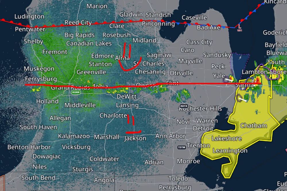
PORT HURON, MI — A line of storms that tracked across Michigan’s Lower Peninsula Thursday evening has prompted meteorologists to investigate a possible tornado damage path stretching from Lapeer to Port Huron, even as the broader severe weather threat across the state began winding down after sunset. As of 9:37 PM EDT, a boundary was draped across the Lower Peninsula, with radar showing a cluster of storms continuing to push south and east toward the St. Clair River and the Canadian border near Sarnia.
A Boundary Splits the State’s Storm Risk
North of the boundary, which stretched roughly from Ludington and Reed City through Clare, Midland, and toward Caseville along the Lake Huron shoreline, severe weather was no longer anticipated for the remainder of the night. South of that line, forecasters kept a small window of concern open, estimating less than a 5 percent chance of an additional severe storm as the boundary continued its slow march southward, producing scattered spotty showers along the way through communities like Grand Rapids, Lansing, and Flint.
The most significant feature on radar by late evening was a strong cell tracking through St. Clair County near Lambton Shores, Chatham, and Leamington along the international border, marked by a tornado warning polygon and clear rotational signatures. This cell followed closely behind the area where the possible Lapeer-to-Port Huron damage track is now being examined, a corridor that passed through Oakland and Genesee County communities including Rochester Hills, Warren, and Novi before continuing northeast toward the Thumb region.
Why Meteorologists Are Investigating a Damage Track
Storm damage surveys are a routine part of confirming whether a line of storms produced a tornado, straight-line wind damage, or a combination of both. When a corridor of reported damage lines up with radar-indicated rotation, as appears to be the case between Lapeer and Port Huron, meteorologists move quickly to gather ground reports, photos, and timestamps before physical evidence like downed trees and structural damage can be cleared or altered.
Local weather teams have asked residents in the affected corridor who sustained damage to share photographs along with the time and location the damage occurred, which helps investigators piece together a consistent timeline of the storm’s path. Confirming a tornado track typically requires matching radar velocity data, damage indicators observed on the ground, and the pattern of debris or fallen trees, since straight-line wind events can sometimes mimic tornado damage without an actual survey team walking the path.
Statewide Storm Behavior Through the Evening
Earlier in the day, the same storm system produced a broader swath of severe weather across the Lower Peninsula, prompting warnings and prompting meteorologists to remain on duty well past when conditions would typically be considered settled. By late evening, however, forecasters described the overall setup as one where the state should generally be finishing its severe weather day, even as a few lingering cells kept a non-zero risk alive south of the boundary.
Communities including Muskegon, Big Rapids, Alma, Saginaw, and Owosso saw the storm line pass through during the height of the activity, with radar showing a mix of heavy rain cores and embedded stronger cells. Farther south, cities such as Kalamazoo, Battle Creek, Jackson, and Ann Arbor remained in the slight residual risk zone as the boundary continued sliding toward the Ohio border overnight.
What Residents Should Do Next
Anyone in the Lapeer to Port Huron corridor who believes they experienced tornado damage is encouraged to document it with photos, along with the approximate time it occurred, to assist local meteorologists and the National Weather Service in confirming the scope and strength of the event. This kind of crowd-sourced reporting has become an increasingly valuable tool for quickly narrowing down survey priorities, especially overnight when official survey teams cannot immediately reach every affected neighborhood.
Residents dealing with storm damage are also reminded to work only with licensed and insured contractors for exterior repairs or tree removal, as severe weather events frequently draw unlicensed operators offering cleanup services in affected communities. Verifying credentials before agreeing to any repair work remains one of the most effective ways homeowners can protect themselves in the aftermath of a damaging storm.
Looking Ahead for Michigan
With the boundary continuing to slide south overnight, the risk of any additional strong to severe storms across Michigan appears to be diminishing heading into the early morning hours. Scattered showers may linger along and south of the boundary as it exits the state, but forecasters do not expect a repeat of the more organized severe weather that impacted the Lapeer to Port Huron corridor earlier in the evening.
Meteorologists will continue reviewing radar data and any submitted damage photos in the coming days as part of the formal survey process, which will ultimately determine whether the corridor’s damage is classified as tornadic or attributed to straight-line wind gusts associated with the broader storm complex.
For continuing coverage of severe weather events and critical storm analysis across the United States, visit svhsnow.com.