LOCK HAVEN, PA — A statistically rare flooding event unfolded just outside Lock Haven, Pennsylvania, Wednesday as an intense, slow-moving storm dumped more than 4 inches of rain in just an hour and a half, triggering rapid roadway flooding and sharp rises on local streams and creeks throughout the surrounding Clinton County countryside.
A Storm That Meant Business
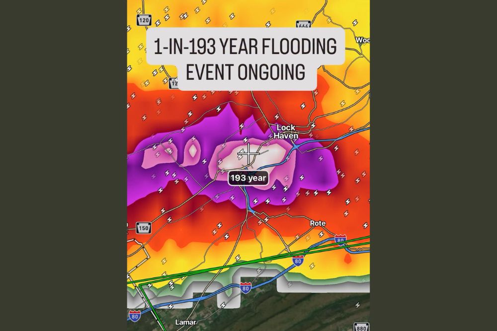
Meteorologists tracking the event described the storm as one that meant business from the outset, with radar-estimated rainfall totals showing a core of extreme precipitation settling directly over the region west of Lock Haven near Route 120 and Route 150. The most intense rainfall totals, shaded in deep purple and white on rainfall analysis maps, marked areas that had already received well over 4 inches of rain in a remarkably short window, with meteorologists warning that additional heavy storms moving through the same corridor could push totals as high as 5 to 6 inches before the event winds down.
Understanding the 1-in-193 Year Statistic
The rainfall analysis for this event flagged the affected area as experiencing what statisticians classify as a 1-in-193 year flooding event, a label that describes the rarity of this magnitude of rainfall occurring in any given location based on historical precipitation data. Meteorologists were careful to clarify exactly what that classification does and does not mean for residents trying to make sense of the numbers.
A 1-in-193 year event does not mean an event of this magnitude will only occur once every 193 years on a fixed schedule. Instead, it reflects a statistical probability, meaning there is less than a half of one percent chance, specifically 0.52 percent, of an event of this rainfall intensity occurring in any single given year at that location. In practice, that means such events, while rare, can theoretically happen in back-to-back years or even multiple times within a shorter stretch, since each year’s odds reset independently of when the last such event occurred.
Rapid Roadway and Stream Flooding
The intensity of the rainfall translated almost immediately into on-the-ground impacts, with roadway flooding reported across the hardest-hit corridor as drainage systems were overwhelmed by rainfall rates far exceeding what typical infrastructure is designed to handle. Streams and creeks throughout the area experienced rapid rises as runoff poured into waterways already unable to absorb additional water, a pattern consistent with flash flooding driven by extremely localized, intense rainfall rather than a broader, longer-duration rain event.
Communities along the West Branch Susquehanna River corridor near Lock Haven, including areas close to Interstate 80, were positioned within or near the highest-intensity rainfall core, raising particular concern given the region’s history of susceptibility to flash flooding during intense convective rainfall events. The compact but extremely intense nature of the rainfall core meant that some nearby areas likely saw dramatically lower totals, underscoring how hyper-localized this type of flash flooding event can be.
Additional Storms Threaten to Worsen the Situation
Forecasters cautioned that the flooding threat had not necessarily peaked at the time of the report, noting that additional heavy storms continuing to track through the same general area could push rainfall totals even higher before the event fully concludes. Any additional rainfall falling atop ground and waterways already saturated by the initial burst would only compound the flooding risk, potentially extending the duration and severity of roadway and stream flooding across the affected corridor.
This kind of repeated training of storms over the same location, where cell after cell moves across an identical path rather than spreading rainfall more evenly across a wider area, is a common driver behind these statistically rare, highly localized flash flooding events. It is also part of why flash flooding can develop and escalate so quickly, often outpacing the ability of longer-range forecasts to fully anticipate the eventual rainfall totals.
What Residents Near Lock Haven Should Know
Residents in and around the affected corridor west of Lock Haven are urged to avoid driving through flooded roadways, since rapidly rising water in flash flood scenarios can conceal washed-out pavement or create currents strong enough to sweep away vehicles. Given the rarity of an event of this magnitude, officials emphasized that even those familiar with the area’s typical flooding patterns should treat this event with heightened caution rather than relying on past experience with more routine rainfall.
Meteorologists will continue monitoring the storm complex closely as it moves through the region, watching for any further intensification of rainfall rates or an expansion of the flash flooding threat into additional communities across north-central Pennsylvania as the event continues to unfold.
For continuing coverage of severe weather events and critical storm analysis across the United States, visit svhsnow.com.