WILLIAMSPORT, PA — A large area of strong to severe thunderstorms continued moving across northern Pennsylvania Wednesday evening, prompting several warnings stretching from north-central Pennsylvania into the Southern Tier of New York as radar showed intense storm cores tracking through the Williamsport and Lock Haven areas with additional cells organizing to the east.
Damaging Winds and Isolated Tornadoes Possible
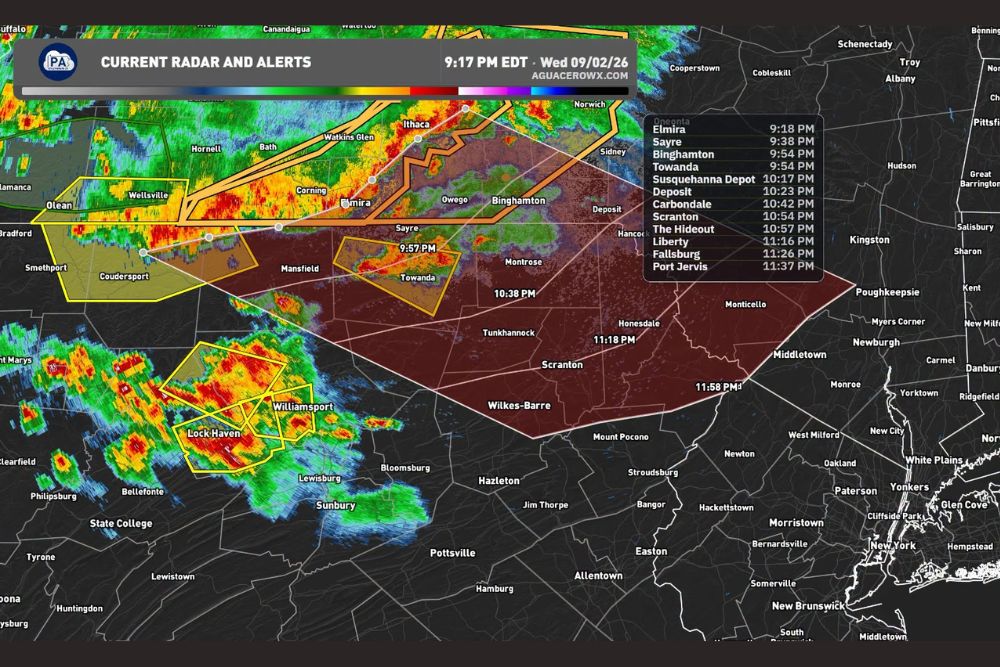
The strongest storms within this line are capable of producing multiple hazards simultaneously, including damaging wind gusts, large hail, torrential rainfall, frequent lightning, and isolated tornadoes. Radar imagery showed well-defined storm cores with the classic hook-shaped signatures associated with rotation moving through the Williamsport and Lock Haven corridor as of 9:17 PM EDT, with warning polygons extending northeast to cover a broad swath of north-central and northeastern Pennsylvania.
Storm Track Pushes Toward Northeastern Pennsylvania
Farther east, the same line of storms is expected to continue advancing toward northeastern Pennsylvania over the next several hours, with forecasters providing a detailed timeline of approximate arrival times for communities in the storm’s path. Sayre is expected to see the storms arrive around 9:37 PM, followed by Towanda around 9:53 PM, Susquehanna Depot around 10:16 PM, Carbondale around 10:41 PM, and Scranton around 10:53 PM, with areas farther east anticipated to see impacts later in the night.
Radar data also indicated the storm complex tracking toward additional communities including Elmira, Binghamton, Deposit, Liberty, Fallsburg, and Port Jervis, with the leading edge of the severe threat expected to push into the Hudson Valley and parts of southern New York state well after 11 PM as the line continues its eastward progression through the overnight hours.
Timing Estimates Come With a Caution
Meteorologists emphasized that the arrival times being circulated are estimates and remain subject to change as the storms evolve in both intensity and forward speed throughout the evening. Storm complexes of this size and organization can accelerate, weaken, or shift track with little notice, meaning residents even slightly outside the currently highlighted corridor should not assume they are entirely in the clear as the system continues to develop.
For that reason, forecasters strongly urged residents across northern and northeastern Pennsylvania, along with the affected portions of the Southern Tier of New York, to keep their phones nearby overnight and ensure emergency weather alerts are enabled. Should a warning be issued for any specific location, the guidance remains consistent: move indoors immediately and stay away from windows until the threat has passed.
Why This Storm Complex Carries Multiple Hazards
The combination of damaging winds, large hail, and isolated tornado potential within the same storm complex reflects a highly energetic atmosphere capable of supporting several severe weather modes simultaneously. Storms of this nature often develop along a broader area of instability and wind shear, allowing individual cells to rotate and intensify as they track across the landscape, which is consistent with the warning-driven cells visible on radar Wednesday evening.
Torrential rainfall embedded within these storms also raises the potential for localized flash flooding, particularly in areas of steeper terrain across north-central Pennsylvania where runoff can quickly overwhelm streams and low-lying roads. Combined with frequent lightning, the overall hazard profile for this event spans nearly every category of severe convective weather short of a widespread tornado outbreak.
What Residents Should Do Overnight
With storms expected to continue tracking east through northeastern Pennsylvania and into parts of New York well past 11 PM, residents throughout the corridor are advised to treat this as an active, evolving severe weather event rather than a single, brief round of storms. Having a reliable way to receive warnings, whether through a weather radio or mobile alerts, remains one of the most effective ways to ensure adequate response time if a warning is issued for a specific location overnight.
Forecasters will continue to monitor the storm complex closely as it advances, watching for any signs of strengthening, additional tornado-warned cells, or an expanding footprint of severe weather as the line pushes deeper into the Northeast through the late evening and overnight hours.
For continuing coverage of severe weather events and critical storm analysis across the United States, visit svhsnow.com.