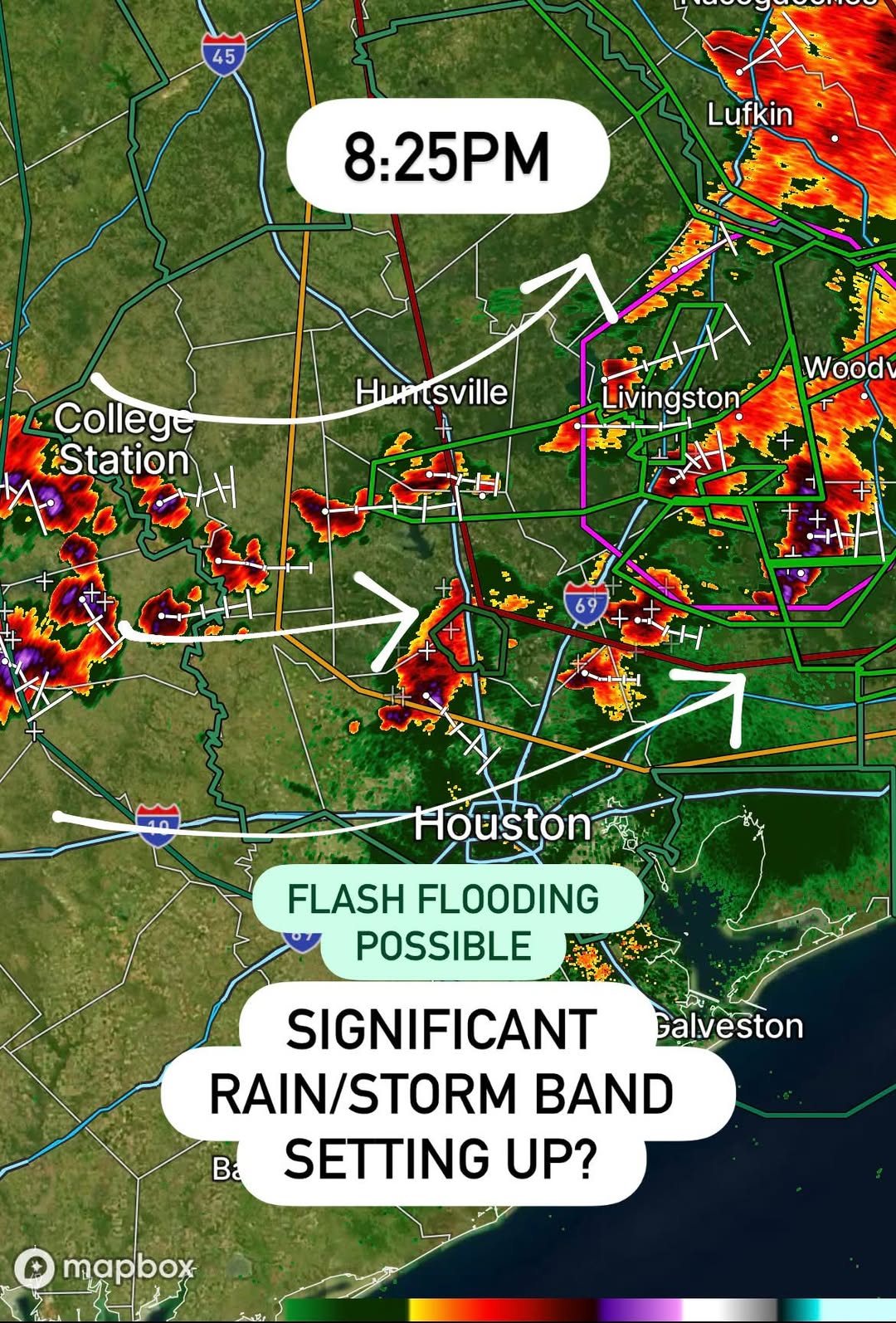
HOUSTON, TX — A newly developing band of heavy rain and thunderstorms began organizing across parts of Southeast Texas Wednesday evening, catching forecasters somewhat off guard as radar showed intense storm cells firing along an axis stretching from College Station and Huntsville through Livingston and toward Lufkin, with additional development pushing south toward the Houston metro area.
An Unanticipated Evening Development
Meteorologists tracking the pattern noted the band forming was slightly unexpected for this stage of the evening, with forecasters describing the setup as a very pronounced axis of heavy rain and thunderstorms taking shape across the region. As of 8:25 PM, radar imagery showed multiple intense cells with embedded rotation signatures stretching in a corridor from west of College Station through Huntsville, Livingston, and the Interstate 69 corridor, with additional storms firing farther east near Lufkin and Nacogdoches.
Edouard’s Lingering Fuel Behind the New Band
The storms developing Wednesday evening are not occurring in isolation. Forecasters attribute the sudden intensification to a combination of factors, including the lingering forcing left behind by Tropical Storm Edouard, an abundance of excess tropical moisture streaming in from the Gulf, and additional atmospheric spin supporting rotation within some of the stronger cells. That combination raised concerns that these thunderstorms could persist and continue rolling through the region for several additional hours rather than quickly weakening after sunset.
Meteorologists indicated the primary threats associated with this developing band include heavy rainfall capable of producing renewed flash flooding, frequent and active lightning, and the possibility of rotating storm cells given the atmospheric spin already in place across the region. That combination is particularly concerning given how saturated the ground across Southeast Texas already is following days of extreme rainfall tied to Edouard’s landfall and slow inland track.
Flash Flooding Risk Returns to an Already Saturated Region
The area now under threat from this new band overlaps significantly with communities that have already experienced significant flooding in recent days, meaning soils and waterways have little to no capacity left to absorb additional rainfall. Any renewed heavy rain falling atop already swollen creeks and rivers can produce flash flooding far more quickly than the same rainfall would in normal conditions, since runoff has nowhere to go but directly into already-strained drainage systems and waterways.
Communities from College Station and Huntsville through the Livingston and Woodville areas, and stretching south toward the Houston metro, are being urged to monitor conditions closely as this band continues to organize. The proximity of the developing storms to Interstate 45 and Interstate 69 also raises concerns for hazardous driving conditions during the evening commute window, with the potential for rapidly reduced visibility and ponding water on major roadways.
Rotation Adds an Additional Layer of Concern
Beyond the flooding threat, radar signatures indicating rotation within some of the stronger cells have added an additional layer of concern for meteorologists monitoring the band. While the primary threat from this system remains heavy rainfall rather than a widespread tornado outbreak, any rotating storm warrants close attention, particularly at night when visual confirmation of developing rotation becomes far more difficult for residents and storm spotters alike.
Active and frequent lightning has also been noted as a consistent feature across the developing band, adding a hazard for anyone outdoors as the storms continue to organize and move through the region. Forecasters have cautioned that the combination of nighttime timing, saturated ground, and active rotation makes this an evening worth monitoring closely rather than assuming the worst of the region’s weather has already passed.
What Residents Should Watch For Tonight
With the band expected to persist for several hours, residents across the Houston, College Station, Huntsville, and Livingston areas are advised to stay weather-aware through the overnight period, avoid driving through flooded roadways, and keep a way to receive emergency alerts close at hand given the possibility of flash flood warnings or even tornado warnings developing with little advance notice.
Forecasters will continue monitoring the axis of storms closely as it evolves, watching for any signs of further intensification or an expanding footprint of flash flooding across a region already stretched thin by the compounding effects of Edouard’s earlier rainfall.
For continuing coverage of severe weather events and critical storm analysis across the United States, visit svhsnow.com.