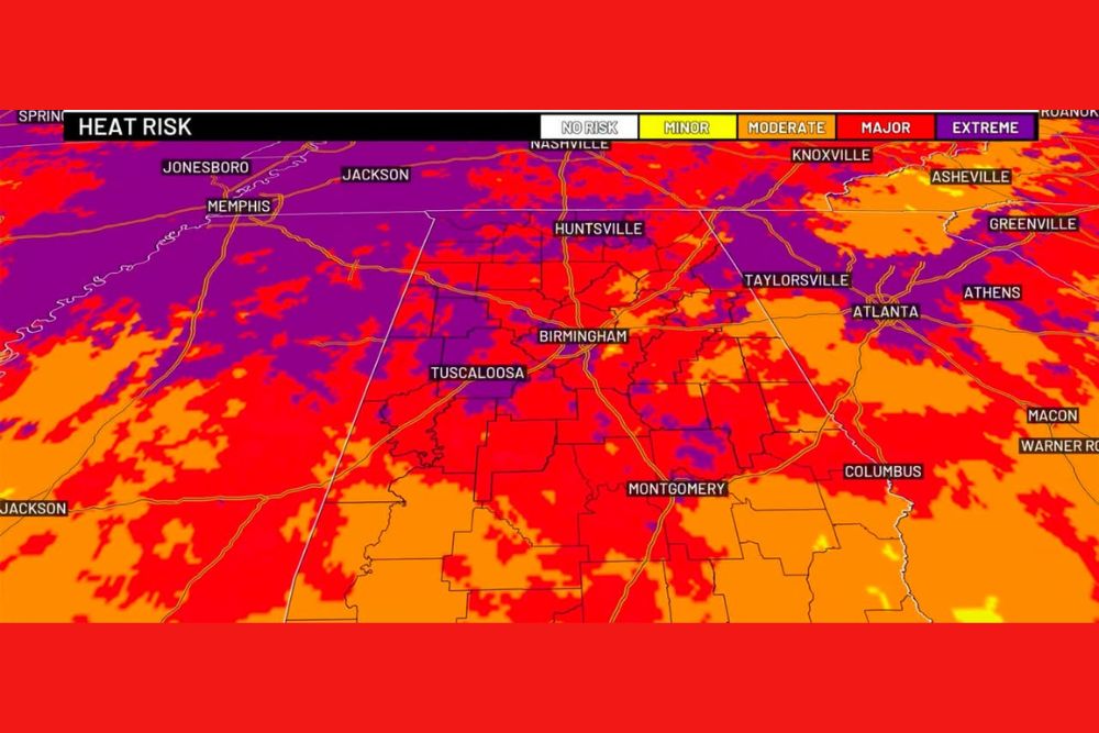
TUSCALOOSA, AL — Dangerous, prolonged heat continued gripping Alabama on Friday as Tuscaloosa chased a third consecutive day at or above 100 degrees, having already reached 101 degrees on each of the past two days, with First Alert Weather Days remaining in effect as an extreme heat risk map showed much of Central and Northwest Alabama shaded in the highest-tier purple and dark red categories.
Extended Duration Makes This Heat Especially Dangerous
Forecasters emphasized that the danger from this heat event extends well beyond the peak afternoon temperature alone. The bigger concern is the extended stretch of intense heat that begins shortly after 9 AM and persists through late afternoon, meaning residents face many consecutive hours of dangerous conditions rather than a brief window around the hottest point of the day. Officials urged residents to check on friends and family throughout the day and make certain vulnerable individuals are staying cool given the sheer duration of the heat exposure.
Scattered Storms Add a Layer of Unpredictability
Despite the oppressive heat, scattered storms have managed to pop up in some of the hottest areas, with a disturbance to the south expected to focus the better rain chances over South Alabama Friday. However, forecasters cautioned that temperatures have consistently run hotter than some model guidance suggested, raising the possibility of additional random, heat-driven pop-up storms developing in areas not initially expected to see rain.
Friday Night Football Brings a Watch for Stray Storms
With high school and college football getting underway Friday night, forecasters noted a stray storm remains possible during games, though any pop-up activity that does develop should be fairly short-lived given the timing. Temperatures are expected to gradually fall into the 80s during the evening hours, with overnight lows settling into the 70s, offering a modest but welcome break from the day’s peak heat for anyone attending games under the lights.
Labor Day Weekend Offers Little Relief
Looking ahead to Saturday, forecasters made clear that meaningful relief remains elusive heading into the holiday weekend. Anyone attending a daytime college football game should prepare for even more intense heat than Friday, with the air temperature in Tuscaloosa expected to be around 91 degrees at kickoff, while temperatures in direct sunshine inside the stadium could approach 97 degrees. Fans were urged to stay hydrated and know the location of cooling stations before heading into the stadium.
Scattered storms remain a concern for Saturday as well, with forecasters noting that given the combination of extreme heat and atmospheric instability, any storm that does develop carries the potential to become strong. A recent example cited by forecasters involved a collapsing thunderstorm between Blountsville and Brooksville that produced intense wind gusts, illustrating how quickly an isolated storm can turn hazardous under these conditions. Storms developing farther north were also being monitored for the possibility of working southward later in the day.
Sunday Through Next Week Stays Hot
The 90s are not expected to disappear anytime soon, with forecasters noting that storm coverage over the weekend could influence Sunday’s high temperatures, particularly across northern and eastern Alabama, though the overall pattern is expected to remain hot regardless. Early next week is generally trending toward highs in the lower 90s, with a continued chance for scattered, random afternoon pop-up storms persisting through the period.
Longer-range data suggests the upper-level ridge responsible for the current heat could strengthen again late next week, potentially ushering in another round of very hot conditions. Forecasters cautioned that even as the calendar pushes into mid-September, triple-digit heat remains entirely possible across Alabama given the current pattern.
Dry Conditions Expected to Worsen
Compounding the heat concern, forecasters noted that widespread, soaking rainfall still is not showing up in the forecast for the days ahead. With rain chances remaining limited heading into next week, dry conditions are likely to continue worsening across portions of the area, adding drought concerns to the list of impacts tied to this stubborn and long-duration heat pattern.
Residents across Alabama are urged to take the ongoing heat seriously, particularly given its extended daily duration, and to continue monitoring forecast updates throughout the holiday weekend as conditions evolve.
For continuing coverage of severe weather events and critical storm analysis across the United States, visit svhsnow.com.