LAS VEGAS, NV — A significant plume of tropical moisture tied to Hurricane Marie will surge northward across the West on Sunday, bringing a widespread increase in rainfall stretching from Southern California through Nevada and into Utah, even as the hurricane itself remains well offshore, with its moisture being drawn north ahead of an approaching trough.
A Widespread Flash Flood Threat Takes Shape
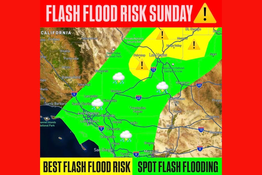
The Weather Prediction Center has placed a broad swath of the Southwest into an elevated risk for excessive rainfall and localized flooding, an area stretching from Southern California into southern Nevada and northwestern Arizona before extending into southern and central Utah. This corridor includes some of the most flash-flood-prone terrain in the entire Southwest, where the combination of unusually deep tropical moisture, disturbances moving through the region, and terrain enhancement is expected to support locally heavier rainfall totals than a typical late-summer storm system.
Forecasters flagged southwestern Utah as an area of particular concern, where slot canyons, normally dry washes, and other sensitive terrain features could become dangerous with very little warning once heavier rainfall begins falling on already parched ground.
Southern California Sees Periods of Rain
Across Southern California, periods of rain along with a few thunderstorms are expected Sunday, with generally moderate rainfall amounts anticipated around the Los Angeles metro area and lighter totals expected closer to San Diego. The moisture and associated rainfall are expected to become considerably more widespread farther inland toward the Mojave Desert, where the combination of tropical moisture and desert terrain can produce locally intense downpours capable of quickly overwhelming the region’s typically arid drainage systems.
Las Vegas and Southern Nevada Face Rising Flood Potential
Rain becomes noticeably more widespread across southern Nevada, including the Las Vegas region, as Sunday progresses. Forecasters warned that locally heavier showers and thunderstorms embedded within the broader moisture plume could produce rapid runoff, ponding on roadways, and flooding of the region’s numerous normally dry washes, features that can transform into dangerous flash flood channels within minutes once sufficient rain begins to fall upstream.
The greatest overall flood potential within the highlighted risk area extends from southern Nevada and northwestern Arizona northeastward into Utah, a corridor where forecast maps showed the flash flood risk elevated to a higher tier surrounding the Las Vegas area and stretching toward St. George and Mesquite.
Utah Faces the Sharpest Flash Flooding Concerns
As the tropical moisture plume continues pushing northeastward, it is expected to bring widespread showers and embedded thunderstorms across Utah, where atmospheric moisture levels could climb to roughly twice normal levels or greater, providing ample fuel for locally heavy rainfall. In response, a Flood Watch has been issued for parts of southern and central Utah, specifically highlighting the danger posed to slot canyons and normally dry washes that are particularly vulnerable to sudden and dangerous flash flooding.
Utah’s iconic slot canyon terrain presents an especially hazardous environment during flash flood events, since these narrow, steep-walled formations can fill with fast-moving water within minutes of rainfall occurring, sometimes even when the rain itself is falling many miles upstream from a canyon’s location, catching hikers and visitors with little to no warning.
Why This Setup Carries Elevated Risk
The interaction between deep tropical moisture from a hurricane remaining offshore and an approaching trough moving through the West represents a classic setup for enhanced rainfall across the interior Southwest. This kind of moisture transport event can deliver rainfall totals far exceeding what the region’s arid terrain and infrastructure are typically designed to handle, significantly raising the risk of flash flooding even in areas that see only moderate overall rainfall amounts.
Terrain enhancement, where mountains and elevated terrain force air to rise and wring out additional moisture, further compounds this risk across the higher elevation areas of Nevada, Arizona, and Utah included in the excessive rainfall outlook.
Critical Safety Guidance for the Region
With flash flooding representing the primary hazard across this multi-state area, forecasters and safety officials emphasized one consistent message: never drive into high water. Floodwaters in desert and canyon terrain can rise with remarkable speed and force, and roadways that appear passable can conceal washed-out surfaces or fast-moving currents strong enough to sweep away vehicles.
Residents and visitors across Southern California, Nevada, Arizona, and Utah are urged to monitor local forecasts closely through the weekend, avoid canyon and wash areas during and after periods of rainfall, and treat any flood watches or warnings in their area with the seriousness the setup demands given the widespread nature of this moisture-driven flooding threat.
For continuing coverage of severe weather events and critical storm analysis across the United States, visit svhsnow.com.