BRIGHTON, CO — A powerful cluster of thunderstorms erupted across the Denver metro area and the I-76 corridor in northeastern Colorado, with radar showing intense cores of heavy rain, gusty winds, and pockets of hail tracking directly over communities including Fort Lupton, Brighton, Thornton, and the vicinity of Denver International Airport.
A Powerful Line Develops Across the Northeast Metro
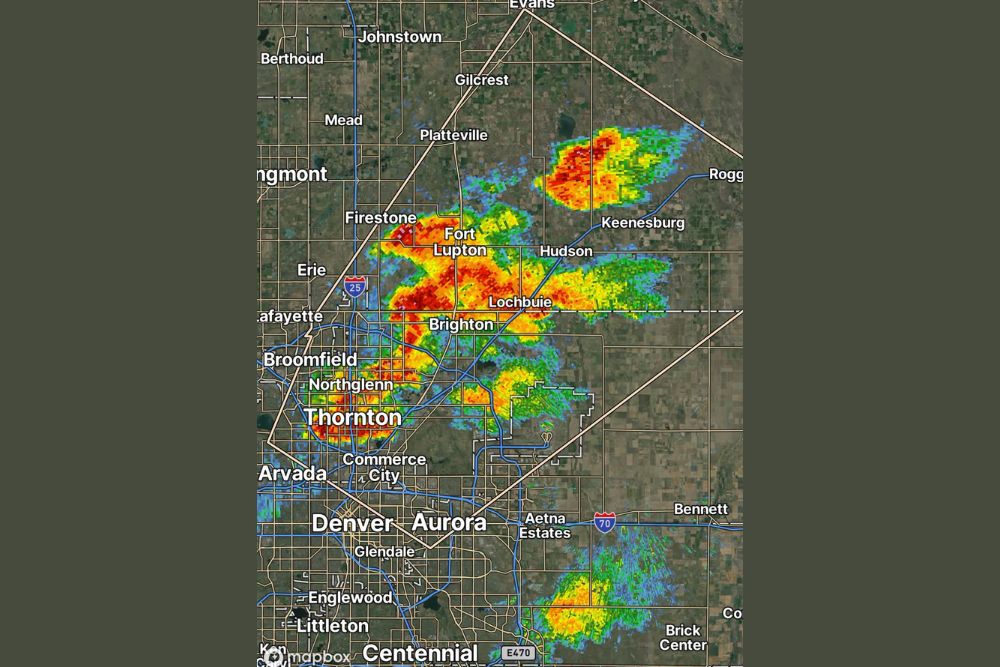
Radar imagery captured an intense line of storms stretching from near Firestone and Fort Lupton southeast through Lochbuie, Brighton, and continuing toward Commerce City and Thornton. The most intense cores, shown in deep red on the reflectivity scale, were concentrated directly over Fort Lupton and Brighton, indicating the heaviest rainfall rates and greatest potential for hail within those specific communities as the storm continued its development.
A second, separate area of intense storm activity was visible farther east near Keenesburg and toward Roggen, showing its own well-defined core of heavy precipitation, while an additional cluster of storms had developed south of the metro area near Aetna Estates and Bennett, close to the Interstate 70 corridor, illustrating just how widespread the afternoon’s convective activity had become across the broader Front Range region.
Gusty Winds, Heavy Rain, and Hail All in Play
The combination of hazards accompanying this storm complex reflects a classic summertime Front Range setup, where daytime heating interacts with sufficient atmospheric moisture and instability to produce multiple threats simultaneously. Gusty winds associated with the stronger cells were capable of downing tree limbs and creating hazardous conditions for high-profile vehicles, while pockets of hail embedded within the more intense cores raised the potential for damage to vehicles, roofing, and landscaping across the directly affected communities.
Heavy rainfall rates within the reddest portions of the storm cores likely produced localized ponding on roadways, particularly across the Fort Lupton and Brighton areas where the most intense radar returns were concentrated, a common consequence when Front Range thunderstorms train repeatedly over the same populated corridor.
Storms Track Directly Over the Airport Corridor
Of particular note, the storm activity was tracking directly across areas near Denver International Airport, a development capable of producing significant disruptions to regional and national air travel given the airport’s status as a major aviation hub. Thunderstorms moving through this corridor often necessitate ground stops, gate holds, or rerouted flight paths, particularly when hail and gusty winds are present alongside more routine rain, since airline and airport operations must account for both passenger safety and potential aircraft damage from hail impacts.
Communities Across the Northeast Metro Feel the Impact
The broad swath of affected communities, stretching from Firestone and Erie in the west through Fort Lupton, Brighton, and Lochbuie in the core impact zone, and extending toward Keenesburg and Hudson to the east, meant a large cross-section of the northeast Denver metro and surrounding rural communities experienced some form of impact from this storm complex simultaneously. Thornton, Northglenn, and Commerce City, all more densely populated suburban communities, also fell within or near the path of the more intense storm activity as it continued tracking through the region.
Why Front Range Storms Often Intensify Quickly
Colorado’s Front Range region is well known among meteorologists for its propensity to produce rapidly intensifying thunderstorms during the summer and early fall months, largely due to the interaction between the terrain of the nearby mountains and the moisture-rich air that frequently settles across the eastern plains. This combination can allow storms to explode in intensity within a relatively short window, catching residents off guard if they are not actively monitoring radar or weather alerts during the afternoon and evening hours when this kind of activity most commonly develops.
What Residents Should Do as Storms Continue
With multiple areas of intense storm activity still active across the region, residents throughout the affected communities are advised to seek shelter indoors, avoid unnecessary travel through the heaviest rain cores, and stay alert for any hail or damaging wind reports that could prompt official warnings from the National Weather Service. Motorists on the I-76 corridor and surrounding roadways should exercise particular caution given the potential for suddenly reduced visibility and ponding water within the more intense sections of the storm complex.
For continuing coverage of severe weather events and critical storm analysis across the United States, visit svhsnow.com.