ADRIAN, MI — The National Weather Service in Detroit/Pontiac issued a Special Weather Statement early Friday for Washtenaw, Lenawee, and Monroe Counties in southeastern Michigan, valid until 8:00 AM EDT, as a strong thunderstorm capable of producing wind gusts up to 40 mph and pea sized hail tracked southeast through the region at a rapid pace.
A Fast-Moving Storm Targets Southeastern Michigan
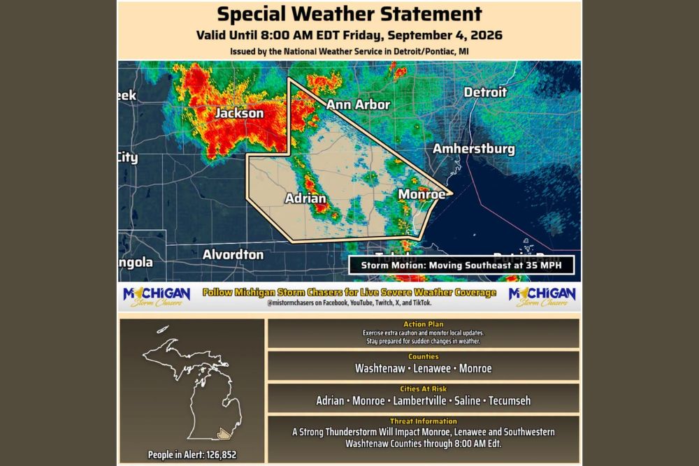
Radar imagery accompanying the statement showed an intense storm cell with a well-defined core of heavy to torrential precipitation stretching from the Jackson area southeast through Ann Arbor, Adrian, and toward Monroe near the Michigan-Ohio border. The storm was tracked moving southeast at a brisk 35 mph, a forward speed that gave residents in its path relatively little advance notice as the system advanced quickly across the warned area.
What the Special Weather Statement Means
A Special Weather Statement is issued by the National Weather Service to alert the public to hazardous weather conditions that do not quite meet the criteria for a full severe thunderstorm warning but still pose a meaningful risk to life and property. In this case, the statement specifically flagged the combination of gusty winds reaching 40 mph and small hail as the primary threats accompanying the storm as it pushed through Washtenaw, Lenawee, and Monroe Counties.
While wind gusts of 40 mph and pea sized hail fall short of the thresholds required for a severe thunderstorm warning, they are still capable of causing minor property damage, downing small tree limbs, and creating hazardous driving conditions, particularly for high-profile vehicles or motorists caught off guard by a sudden burst of gusty wind and hail along the roadway.
Cities Directly in the Storm’s Path
The National Weather Service specifically identified Adrian, Monroe, Lambertville, Saline, and Tecumseh as cities at greatest risk from the strong thunderstorm as it continued its southeastward trajectory. Combined, the alert covered an estimated 126,852 people across the three affected counties, underscoring the relatively densely populated nature of this stretch of southeastern Michigan compared to more rural areas farther west where the storm initially developed.
The threat information accompanying the statement specified that the strong thunderstorm would primarily impact Monroe, Lenawee, and southwestern Washtenaw Counties through the 8:00 AM expiration time, giving residents in those specific areas the clearest window for when to expect the most direct impacts from the passing storm.
Recommended Action for Residents
The National Weather Service’s guidance for those within the alert area centered on exercising extra caution and closely monitoring local weather updates as the storm continued its rapid movement through the region. Given the fast forward speed of 35 mph, conditions were expected to change quickly, reinforcing the importance of staying prepared for sudden shifts in weather rather than assuming a slower-developing threat.
Motorists across the affected counties, particularly those on roadways near Adrian, Tecumseh, and Monroe, were advised to be especially attentive given the combination of gusty winds and small hail, both of which can reduce visibility and traction on the road with very little warning as a fast-moving storm cell passes overhead.
Storm Continues Toward Lake Erie
As the storm continued its track southeast, its trajectory pointed it toward the Monroe area and ultimately the western shore of Lake Erie, a path that would carry it out of the three warned counties as it approached the state line and the Ohio border near Toledo. Communities along that final stretch of the storm’s path, including areas near Amherstburg just across the international border, were also positioned to see effects from the storm as it exited southeastern Michigan.
Meteorologists will continue monitoring the storm and any additional cells trailing behind it, watching for signs of further intensification that could necessitate an upgrade to a more serious warning level before the special weather statement’s 8:00 AM expiration.
For continuing coverage of severe weather events and critical storm analysis across the United States, visit svhsnow.com.