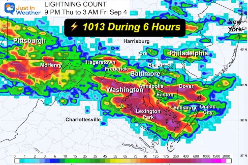
SYKESVILLE, MD — A spectacular overnight lightning display lit up the skies across Maryland early Friday, with 1,013 lightning strikes recorded in the six-hour window between 9 PM Thursday and 3 AM Friday, leaving residents across the region treated to what meteorologists described as an amazing lightning show overnight.
A Six-Hour Barrage of Electrical Activity
Lightning tracking data covering the overnight period showed the intense strike count concentrated across a corridor stretching from the Harrisburg and Hagerstown areas of Pennsylvania down through Frederick, Baltimore, Bel Air, and Annapolis in Maryland, with additional activity extending toward Washington, D.C., Dover, and Salisbury. The density map showed the heaviest concentration of strikes forming a broad band across central Maryland, consistent with a well-organized line or cluster of thunderstorms that maintained strong electrical activity for a sustained stretch of the night rather than a single brief burst.
Striking Photography Captures the Storm’s Intensity
Photographer Nick Proudfoot captured a series of standout images of the lightning show from over Sykesville, Maryland, documenting sprawling branches of cloud-to-ground and cloud-to-cloud lightning illuminating the night sky against a backdrop of distant storm clouds tinged with the warm glow of scattered city lights below. The photographs showcase the kind of expansive, highly branched lightning structure that tends to accompany a mature, electrically vigorous thunderstorm complex, with jagged bolts stretching across large portions of the visible sky in single exposures.
Why This Storm Produced Such Intense Lightning
A total exceeding 1,000 strikes across a six-hour period reflects a thunderstorm complex with sustained and vigorous internal dynamics, the kind capable of continuously separating electrical charge within the storm through the collision of ice particles in its upper levels. Storms capable of maintaining this level of output over several hours, rather than a short-lived peak, typically indicate a well-organized system with enough sustained instability and moisture to keep producing strong updrafts throughout the overnight period.
The overnight timing of the event likely made the lightning particularly striking for anyone awake to witness it, since darkness dramatically increases the visibility of distant lightning compared to daytime hours, allowing bolts from storms many miles away to appear vivid against the night sky even when the storm’s core remained a significant distance from the observer.
Thundershowers Not Finished Just Yet
While the most intense overnight lightning activity has passed, meteorologists cautioned that the region is not entirely done with unsettled weather. Scattered thundershowers may continue to linger into Saturday, meaning residents should not assume the wet and occasionally active pattern has fully wrapped up simply because the most dramatic overnight lightning has subsided.
The broader weekend outlook, however, points toward improving conditions, with forecasters indicating that the remainder of the weekend should trend cooler and quieter once the lingering Saturday thundershower chances move out of the region. That shift would offer a welcome change of pace following the intensity of Thursday night’s electrical activity across the state.
Staying Weather Aware as More Storms Are Possible
With additional thundershower chances still on the table for Saturday, residents across Maryland and the surrounding Mid-Atlantic region are encouraged to remain weather-aware even as the most dramatic overnight activity fades into the morning. Lightning remains a serious hazard any time thunderstorms are present, regardless of whether the broader system is expected to reach severe criteria, and the standard safety guidance of moving indoors at the first sound of thunder continues to apply.
Local meteorologists indicated that updated morning forecast guidance was expected to be available by 7 AM, offering residents a clearer picture of exactly how the Saturday thundershower chances are likely to play out before the anticipated cooler and quieter stretch settles in for the remainder of the weekend.
Looking Ahead for Maryland
As the overnight storm system continues to exit the region, attention now turns to how quickly the lingering thundershower chances clear out heading into Saturday. Forecasters will continue refining the timeline for when drier, cooler conditions are expected to fully take hold across Maryland and the broader Mid-Atlantic as the weekend progresses.
For continuing coverage of severe weather events and critical storm analysis across the United States, visit svhsnow.com.