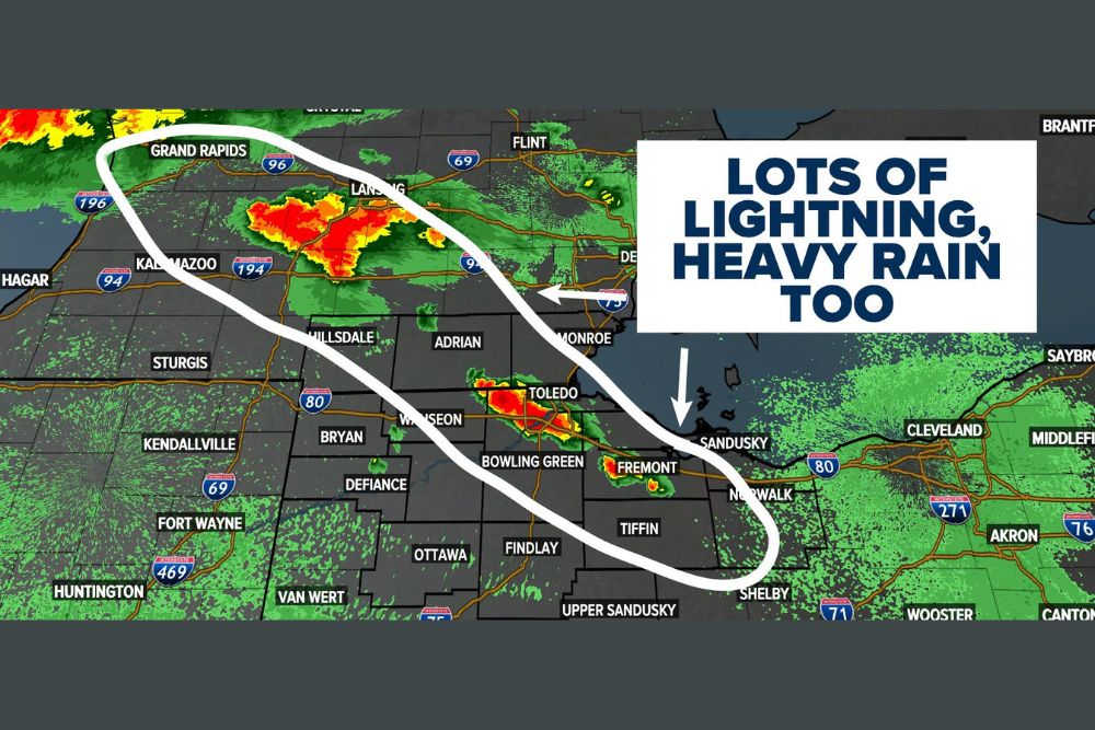
TOLEDO, OH — A round of Friday morning thunderstorms fired up early across parts of Michigan and Ohio, with WTOL 11’s Doppler Radar showing intense storm cores already producing frequent lightning and heavy rainfall across the Grand Rapids, Kalamazoo, Toledo, and Fremont areas as of 5:28 AM, with the activity expected to continue repeating through the late morning hours.
Thunder Rolls Across the Region Before Sunrise
The storms began developing well before daybreak, catching many residents’ attention as rumbles of thunder rolled across communities from southwestern Michigan down through northwestern Ohio. Radar imagery showed multiple areas of heavy to torrential rainfall, marked in red and orange on the reflectivity scale, concentrated near Grand Rapids and Kalamazoo in Michigan, along with a second cluster of intense storms tracking through the Toledo, Bowling Green, and Fremont corridor in Ohio.
Repeated Rounds Expected Through Lunchtime
Meteorologists tracking the pattern indicated that many residents across the highlighted corridor should expect to see repeated thunderstorms and downpours throughout the morning rather than a single, brief round of activity. A broad corridor stretching from the Grand Rapids and Lansing area of Michigan southeast through Toledo, Fremont, and toward Norwalk in Ohio was identified as the zone where storms are most likely to continue developing and redeveloping through roughly lunchtime.
That repeated nature of the activity is what raises the rainfall threat significantly compared to a typical passing thunderstorm. When successive rounds of storms track over similar areas throughout the morning, rainfall totals can accumulate quickly even if no single storm produces an extreme rate on its own, since the cumulative effect of storm after storm passing through the same corridor adds up over several hours.
Lightning the Primary Concern, Not Severe Weather
Forecasters were clear that severe weather, meaning damaging winds, large hail, or tornadoes, was not considered likely with this particular round of storms. Instead, the primary hazards were identified as frequent lightning and the potential for locally heavy rainfall, a combination that, while less dramatic than a severe weather outbreak, still carries real risks for anyone caught outdoors during the more intense bursts of activity.
Frequent lightning associated with these storms means residents across the affected corridor should still exercise caution during the more active periods, particularly given the storms’ tendency to redevelop repeatedly through the morning rather than clearing out after a single pass. The classic guidance of seeking shelter indoors during thunder and lightning remains relevant even for storms not expected to reach severe criteria.
Rainfall Totals Could Reach 1 to 2 Inches
Within the highlighted corridor stretching from western Michigan through north-central Ohio, meteorologists indicated that heavy rain totals between 1 and 2 inches will be possible by the time the morning’s activity winds down. That range of rainfall, particularly if it falls in a relatively short window due to the repeated nature of the storms, carries the potential for localized ponding on roadways and minor drainage issues in low-lying areas, even without a formal flood warning being issued.
Communities including Grand Rapids, Kalamazoo, Hillsdale, Toledo, Bowling Green, Fremont, and Tiffin all sit within or near the zone forecasters flagged as most likely to see the heaviest and most repeated storm activity through the late morning hours, making these areas the most likely to approach or exceed the higher end of the expected rainfall range.
What to Expect as the Morning Progresses
As the morning continues, residents across the affected stretch of Michigan and Ohio should anticipate a pattern of storms moving through, briefly clearing, and then redeveloping again as the atmosphere continues to support new thunderstorm activity. This kind of repeating morning convection is common ahead of a more organized frontal boundary or in a moisture-rich, unstable airmass, both of which appear to be contributing factors behind Friday’s active start to the day.
Meteorologists will continue monitoring radar trends closely through the late morning, watching for any signs of the activity beginning to taper off as expected around lunchtime, while also keeping an eye out for any localized storms that manage to produce rainfall rates heavier than currently anticipated.
For continuing coverage of severe weather events and critical storm analysis across the United States, visit svhsnow.com.