ALLEN, TX — A heavily overperforming storm is pouring down torrential rain across portions of Collin County, Texas, with radar showing intense, slow-moving downpours delivering a good soaking to communities including Allen, Fairview, Parker, and McKinney as the system continues tracking north around 7 PM. Forecasters described the storm as significantly outperforming initial expectations, producing a more substantial rainfall event than what had been anticipated for this particular system.
Intense Rainfall Concentrated Over Central Collin County
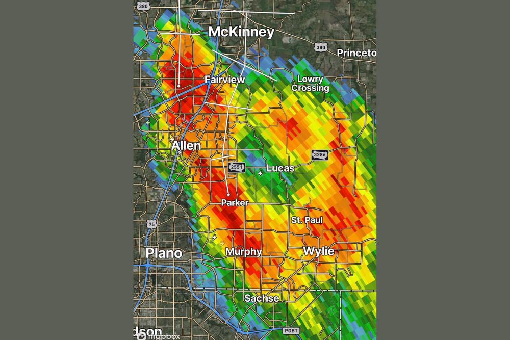
Radar imagery shows the most intense areas of rainfall, indicated by deep red coloring, concentrated over a corridor stretching from McKinney and Fairview in the north down through Allen and Parker toward the south. This core area of heaviest rainfall appears to be tracking in a north-to-south oriented band, with the most extreme rainfall rates falling directly over these central Collin County communities.
The storm’s structure on radar shows a well-organized, linear band of precipitation extending from the heaviest core near Allen and Parker outward toward Lucas, St. Paul, and Wylie to the east, illustrating the broader reach of moderate to heavy rainfall accompanying the more intense core of the system.
Storm Significantly Outperforms Expectations
Forecasters specifically noted that this storm is really overperforming, a description that suggests the system has developed and intensified beyond what initial forecasts had anticipated for the area. This kind of unexpected intensification is not uncommon with individual thunderstorm cells, particularly when favorable moisture and instability allow a storm to organize and strengthen more than models initially projected.
The overperforming nature of this storm means communities within its path are likely receiving significantly more rainfall than they may have anticipated based on earlier forecasts, a reminder of how quickly individual storm cells can exceed expectations once they become established and begin efficiently producing heavy rainfall.
A Good Soaking for Parts of Collin County
Forecasters characterized the rainfall from this storm as a good soaking for parts of Collin County, language that suggests the rain, while heavy and locally intense, is being viewed as a beneficial rainfall event rather than one primarily associated with severe weather concerns. This framing indicates the storm’s main story is substantial rainfall accumulation rather than damaging winds, hail, or other severe weather hazards.
Communities within the heaviest rainfall corridor, particularly Allen, Fairview, and Parker, are likely seeing the most substantial benefit from this soaking rain, given their position directly beneath the most intense portion of the storm as shown on radar.
Storm Continues Tracking North Toward McKinney
As of 7 PM, the storm was continuing to move north, placing McKinney and areas toward Princeton in the storm’s path as it progresses. This northward track suggests communities that have not yet received the heaviest rainfall, particularly those in the northern portion of the affected corridor, should prepare for the storm’s more intense core to arrive as the system continues its movement.
The storm’s continued progression northward also suggests that areas farther south, including Plano and Sachse, which appear to be on the edge or just outside the heaviest rainfall core based on current radar, may see the storm’s influence diminish as the system continues to track away from their location.
Broader Rainfall Coverage Extends Across the County
Beyond the most intense core of rainfall, radar shows a broader area of light to moderate precipitation extending across a significant portion of Collin County, reaching communities including Lowry Crossing, Murphy, and Wylie. This wider footprint indicates that while the heaviest rainfall remains concentrated in the central portion of the county, a much larger area is experiencing at least some rainfall from this broader weather system.
The presence of this wider rainfall shield surrounding the more intense core is typical of a mature, well-developed thunderstorm complex, where a central area of the heaviest precipitation is often accompanied by more extensive, lighter rainfall across the surrounding region.
What Residents Should Expect
Residents across Collin County, particularly those in and around McKinney, Fairview, Allen, and Parker, should prepare for continued heavy rainfall as this overperforming storm continues its northward track through the early evening hours. Given the intensity already observed with this system, residents should exercise caution on roadways, particularly in low-lying areas prone to ponding during periods of heavy rainfall.
For continuing coverage of severe weather events and critical storm analysis across the United States, visit svhsnow.com.