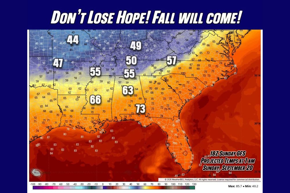
ATLANTA, GA — A long-range forecast model is offering an early glimmer of hope for anyone tired of the summer heat, projecting temperatures in the 40s and 50s stretching across much of the Tennessee Valley, Appalachians, and Mid-South by the morning of Sunday, September 20th, a sign that at least somewhere in the coming two to three weeks, meaningfully cooler air appears poised to make a genuine push south.
A Striking Temperature Contrast on the Forecast Map
The 18Z Sunday GFS model, projecting temperatures for 7 AM on September 20th, shows a dramatic divide across the eastern United States. Communities across the northern and central Appalachians and Tennessee Valley, including areas registering 44 to 49 degrees, sit in stark contrast to the still-warm conditions gripping Florida and the Gulf Coast, where projected temperatures remain in the 70s and low 80s. That divide illustrates just how significant this potential cool shot could be for areas positioned to receive it, even as more southern and coastal locations remain locked into a warmer pattern.
Specific projected readings on the map include 50 degrees in parts of Kentucky, 55 degrees across sections of Tennessee and Georgia, 57 degrees in parts of the Carolinas, and 63 degrees farther south into Alabama, with Atlanta itself projected around 66 degrees at that early morning hour. These numbers, while not universally cold, represent a substantial and legitimately refreshing departure from the heat that has dominated the region throughout much of the late summer.
Why This Forecast Comes With Real Caveats
Meteorologists were careful to frame this projection with appropriate caution, noting that two weeks out is a considerable distance for any single forecast model to accurately pin down exact numbers for a specific date. Model guidance at this range is known to shift considerably as the actual date approaches, meaning the specific temperatures shown on this particular run should be viewed as illustrative of a broader pattern signal rather than a locked-in prediction for September 20th itself.
Despite that necessary caveat, forecasters indicated they were genuinely pulling for this outcome to verify, reflecting both the significance of the potential pattern change and the understandable eagerness among residents and meteorologists alike for a legitimate break from the extended stretch of summer heat that has characterized the region’s recent weather.
A Broader Signal Worth Watching
Even if the specific date or exact temperatures shown in this model run do not verify precisely as depicted, forecasters emphasized that the appearance of this kind of cooler signal carries broader significance. At minimum, it suggests that somewhere within the next two to three weeks, the current heat pattern gripping the Southeast is likely to break, allowing genuinely cooler air to finally make a meaningful push southward into the region.
This kind of long-range signal, even when uncertain in its precise timing and magnitude, gives meteorologists an early indication that the atmospheric pattern responsible for the region’s persistent late-summer heat may not remain entrenched indefinitely, offering residents a data-backed reason for optimism after weeks of oppressive conditions.
Why September 20 Would Represent Meaningful Timing
A pattern change of this magnitude arriving by September 20th would align reasonably well with the broader seasonal transition typically expected as September progresses, when the jet stream begins shifting in ways that more regularly allow cooler air masses to reach farther south compared to the deep summer months. If this signal does verify in some form, even with different specific numbers than currently projected, it would represent a meaningful and welcome shift for a region that has endured an unusually persistent and intense heat pattern in recent weeks.
What Residents Should Take From This Outlook
Given the acknowledged uncertainty inherent in a forecast this far out, residents across the Southeast should treat this projection as an encouraging early signal rather than a guarantee of specific conditions on September 20th itself. As is standard practice with long-range model guidance, confidence in the details is expected to sharpen considerably as the date in question draws closer and additional model runs become available to confirm or adjust the current signal.
For continuing coverage of severe weather events and critical storm analysis across the United States, visit svhsnow.com.