DAYTON, OH — Tomorrow morning is likely to start with scattered storms across the Dayton and Cincinnati areas as a weather system lifts northeast through the region, with forecasters saying elevated instability means residents will definitely see some thunderstorm activity, along with the possibility of locally heavy rain. While no severe weather is expected with this system, the combination of instability and available moisture is enough to produce meaningful rainfall for portions of southwestern Ohio.
Radar Shows Storms Already Developing Overnight
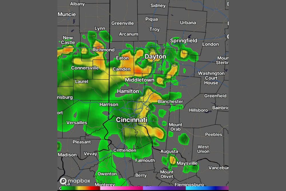
Radar imagery from 9:41 PM on September 11 already shows an extensive area of showers and thunderstorms stretching from near Richmond, Indiana, eastward through Eaton, Camden, and directly over the Dayton metro area, with additional cells extending south through Middletown, Hamilton, and into Cincinnati. This overnight activity represents the early stages of the system forecasters expect to bring scattered storms through the morning hours.
The radar display shows several areas of more intense yellow and orange coloring embedded within the broader green shading, particularly near Eaton, Camden, and portions of Dayton and Cincinnati, indicating pockets of heavier rainfall already occurring as the system continues its slow progression through the region overnight.
Morning Activity Expected From 4 AM to 9 AM
Forecasters specifically outlined the window from 4 AM to 9 AM as the most likely period for scattered storm activity tomorrow morning, as the system responsible for tonight’s rainfall continues lifting northeast through the region. This timeframe suggests residents in the Dayton and Cincinnati areas should expect the possibility of encountering rain and thunderstorms during the early morning commute.
The elevated instability present within the atmosphere ahead of this system is the key factor forecasters point to in explaining why thunderstorm development, rather than just steady rain, is expected during this morning window, even though the overall severe weather threat remains low.
No Severe Weather Expected Despite Storm Activity
Despite the presence of elevated instability and the expectation of definite thunderstorm activity, forecasters were clear that no severe weather is expected with tomorrow morning’s system. This distinction is important for residents across the Dayton and Cincinnati metro areas, as it suggests the primary story with this system will be rainfall totals and general thunderstorm activity rather than damaging winds, large hail, or tornado potential.
That said, forecasters did note that locally heavy rain is possible, meaning some communities within the path of the more intense storm cells could see brief periods of significant rainfall even without the storms reaching severe criteria.
Dry Pockets Expected Following the Morning Activity
Following the anticipated morning storm activity, forecasters indicated that the region should catch some dry pockets, offering a break in the rain and thunderstorm activity before any additional development later in the day. This expected lull suggests the morning’s scattered storms will not persist continuously throughout the entire day, giving residents a window of drier weather at some point following the initial morning system.
That anticipated break is a useful detail for anyone planning outdoor activities, suggesting the timing of any such plans around the midday hours, after the morning storms clear but before any afternoon redevelopment, could offer the most favorable conditions.
Additional Scattered Storms Possible in the Afternoon
Beyond the morning activity, forecasters noted that additional scattered storms may develop during the afternoon hours, suggesting tomorrow could feature more than one round of thunderstorm activity across the Dayton and Cincinnati region. This afternoon redevelopment is a common pattern when daytime heating interacts with lingering atmospheric instability following an earlier round of storms.
Residents should be prepared for the possibility of encountering scattered storms at multiple points throughout the day tomorrow, rather than assuming that once the morning activity clears, the day will remain storm-free through the evening hours.
What Residents Should Expect
Residents across the Dayton and Cincinnati metro areas, along with surrounding communities including Middletown, Hamilton, and Richmond, should prepare for scattered storms and the possibility of locally heavy rain during the 4 AM to 9 AM window tomorrow morning, followed by potential drier conditions and then a chance of additional afternoon storm development. While severe weather is not expected, the combination of thunderstorms and heavy rain potential still warrants normal weather awareness for morning commuters.
For continuing coverage of severe weather events and critical storm analysis across the United States, visit svhsnow.com.