INDIANAPOLIS, IN — A massive area of returns surrounding the KIND radar across central Indiana on Saturday night is not precipitation at all, but rather millions of birds taking flight as part of the ongoing fall migration. Doppler radar is capable of picking up large numbers of birds moving through the atmosphere, and when enough take to the sky simultaneously, they can produce a striking signature on weather radar that looks surprisingly similar to rain.
A Massive Radar Signature Spans Central Indiana
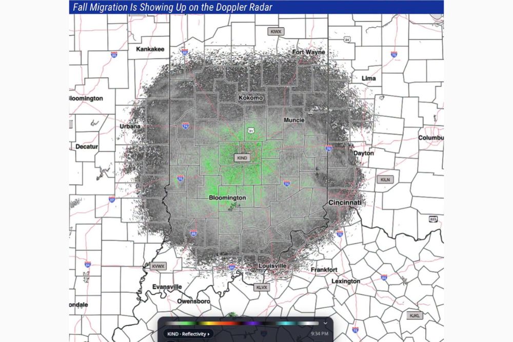
Radar imagery captured at 9:34 PM shows an enormous, roughly circular area of returns centered on the KIND radar site and extending outward across a huge swath of central Indiana, reaching as far as Kankakee and Fort Wayne to the north, Cincinnati and Columbus to the east, and Louisville and Bloomington to the south. The sheer scale of this signature illustrates just how many birds are participating in tonight’s migration event across the region.
The radar display shows a textured, speckled pattern distinct from typical precipitation returns, with a brighter green core near the radar site itself gradually fading into grayer tones toward the edges of the detected area, a visual signature characteristic of biological targets like birds rather than raindrops or ice.
How Doppler Radar Detects Migrating Birds
Weather radar works by sending out pulses of energy and measuring what bounces back, a process originally designed to detect precipitation but one that also picks up other objects in the atmosphere, including birds, insects, and even bats. When millions of birds take flight simultaneously during a mass migration event, their combined presence in the atmosphere can create a radar return substantial enough to closely resemble a large area of light rain or drizzle.
This phenomenon is well documented among meteorologists and ornithologists alike, and has become an increasingly recognized tool for tracking the timing and scale of bird migration events, particularly during the peak spring and fall migration seasons when bird activity in the atmosphere reaches its highest levels.
Fall Migration Reaches a Notable Peak
Tonight’s radar signature suggests that fall bird migration has reached a particularly active point across the central Indiana region, with the scale of the detected activity described as an impressive display. Fall migration typically involves numerous bird species traveling south from northern breeding grounds toward wintering areas, a journey many species undertake primarily during nighttime hours to avoid predators and take advantage of cooler, calmer atmospheric conditions.
The timing of this radar signature, occurring well after sunset, is consistent with the nocturnal migration patterns exhibited by many songbird species, which frequently fly at night and rest and feed during daylight hours as they make their way along established migratory routes.
A Regionwide Phenomenon Beyond Just Indianapolis
While the radar imagery centers on the KIND site near Indianapolis, the scale of tonight’s bird migration signature suggests this is a broader regional phenomenon affecting bird populations across a wide stretch of the Midwest and beyond. Similar radar signatures are likely visible on neighboring radar sites throughout the region on nights when migration activity peaks simultaneously across a broad geographic area.
This kind of widespread nocturnal migration activity typically coincides with favorable wind patterns and clear atmospheric conditions, factors that can encourage large numbers of birds across many different populations to begin or continue their southward journey on the same night.
An Educational Moment for Radar Watchers
Events like tonight’s bird migration signature serve as a valuable reminder that not everything appearing on weather radar represents precipitation, offering an educational opportunity for those who regularly follow radar imagery for weather updates. Distinguishing between a genuine precipitation signature and a biological one, such as birds or insects, is an important skill for both professional meteorologists and radar-savvy members of the public alike.
For casual radar watchers who might otherwise mistake tonight’s signature for an unexpected area of rain, this event highlights the fascinating overlap between meteorology and ornithology, and the surprising ways in which weather radar technology can reveal insights well beyond its original precipitation-tracking purpose.
What This Means for the Coming Weeks
With fall migration now clearly underway and reaching a notable peak over central Indiana, similar radar signatures are likely to reappear on additional nights throughout the coming weeks as migration activity continues across the region. Bird watchers and radar enthusiasts alike may continue to see comparable displays on clear nights with favorable migratory conditions as the broader fall migration season progresses.
For continuing coverage of severe weather events and critical storm analysis across the United States, visit svhsnow.com.