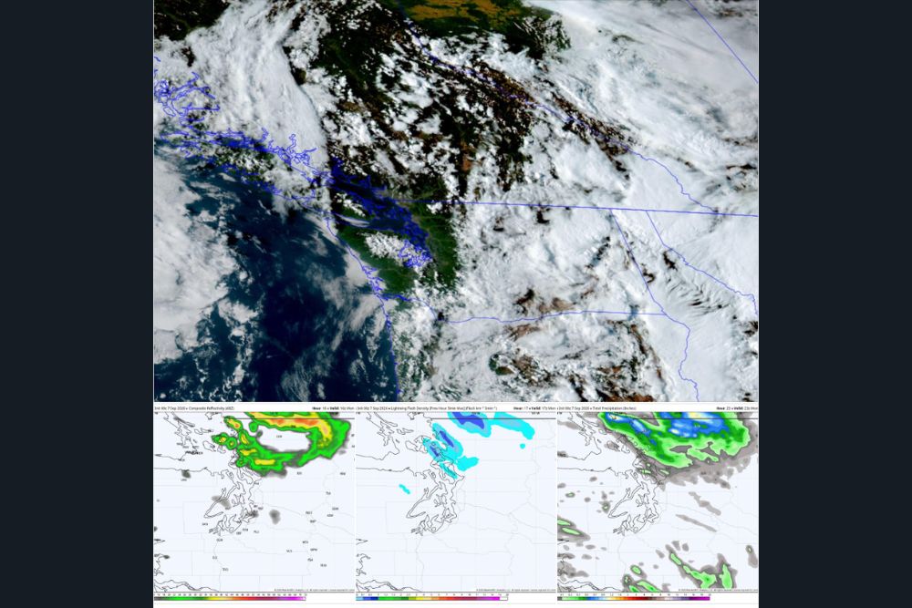
EVERETT, WA — A brief round of unexpected showers, and possibly a few thunderstorms, may sweep across the North Sound region of Washington on Labor Day, catching many off guard just as the weekend’s earlier storm system appeared to be exiting the region, with model guidance now suggesting the atmosphere may have one more parting shot for the Northwest Interior before a warmer, sunnier pattern finally settles in.
A Weekend Already Full of Weather Mischief
The Seattle area’s holiday weekend has already featured its share of unsettled weather, with thunderstorms firing up across the region Friday and Saturday courtesy of a low-pressure system spinning showers and storms around the Pacific Northwest. While that same system was heading east and away from the region, higher-resolution forecast models began picking up on an additional batch of moisture currently positioned over the heart of British Columbia, moving south and potentially delivering one more round of showers into the Northwest Interior and possibly the North Sound on Monday.
Tracking the Timeline for Monday’s Showers
According to the latest model scenario, this batch of moisture, informally described by forecasters as a “blob” of showers, is expected to arrive in southwestern British Columbia and along the Strait of Georgia in the pre-dawn hours Monday morning. From there, the showers would track south and southeast across the Northwest Interior, arriving around sunrise, before pushing into the Interstate 5 corridor north of roughly Everett during the morning hours.
Forecasters indicated the showers would then push off to the east by midday or early afternoon at the latest, allowing the remainder of Monday to rapidly clear and dry out across the region. Some model runs had even extended the reach of this brief rain event as far south as the Seattle-Bellevue area Monday morning, though forecasters noted the chances there remain lower, with most of the later model runs keeping the bulk of the moisture confined north of about Everett.
Isolated Lightning Possible, But Limited Storm Potential
Some indications in the model data suggest a few lightning strikes could be mixed into Monday’s shower activity, primarily across the northern portion of the affected area. However, forecasters cautioned that with the low-pressure center much farther away compared to earlier in the weekend, there does not appear to be enough atmospheric instability present to fire off thunderstorms with the same intensity witnessed during Friday and Saturday’s activity.
The timing of the showers, arriving during the coolest part of the day with limited sunshine due to a possible morning marine layer, works against more robust thunderstorm development as well, since daytime heating typically plays a key role in generating the instability needed for stronger storms to form.
Coastal Areas and Points South Expected to Stay Clear
While the North Sound and areas near and north of Everett carry the best chance of seeing Monday morning showers, coastal areas, the Olympic Peninsula, and locations south of roughly Tacoma are expected to remain largely in the clear as far as this particular batch of moisture is concerned, aside from the possibility of some morning marine layer clouds. Given that the overall forecast had been leaning fairly dry for Monday prior to this update, forecasters felt it worthwhile to flag the change for anyone with outdoor plans in the affected northern areas.
Sunshine and Warmth Return as the Work Week Begins
Once Monday’s brief shower threat clears out, the forecast turns notably sunnier and warmer just as the three-day holiday weekend comes to a close. High pressure is expected to build in starting Tuesday, bringing a return of summer-like conditions for approximately 72 hours, with highs reaching the mid-70s Tuesday and climbing into the upper 70s, with the possibility of touching 80 degrees, by Wednesday, before temperatures cool slightly again by Thursday.
Rain Signals Return Ahead of the Following Weekend
Looking further ahead, long-range forecast guidance is already hinting at another trough moving into the Pacific Northwest for the following Friday and Saturday. While forecasters indicated this system may not be quite as potent as the one responsible for this weekend’s thunderstorms, it does appear capable of bringing a return of cooler temperatures and scattered showers as the next weekend approaches.
What Northwest Residents Should Expect
Given the uncertainty still surrounding the exact placement and intensity of Monday’s shower activity, residents across the North Sound and Northwest Interior with outdoor plans on Labor Day are encouraged to check radar in the morning hours to see how the situation is evolving in real time, since forecasters emphasized this is expected to be a brief morning nuisance rather than a washout kind of day regardless of how it ultimately unfolds.
For continuing coverage of severe weather events and critical storm analysis across the United States, visit svhsnow.com.