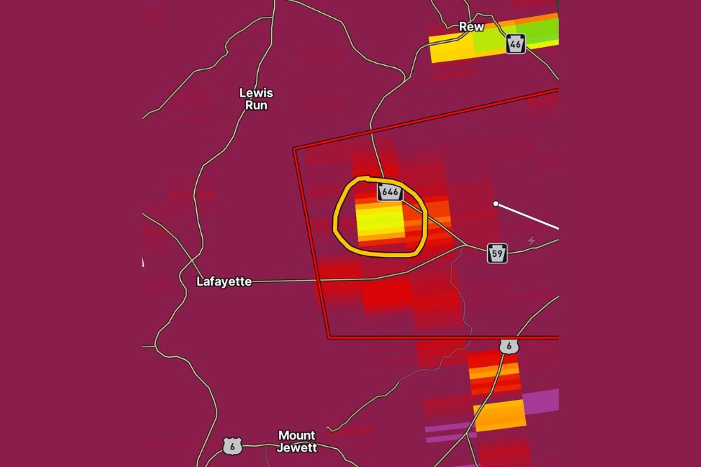
LAFAYETTE, PA — A possible tornado debris signature appeared on radar east of Lafayette, Pennsylvania, in McKean County at approximately 7:24 PM, prompting officials to seek reports from anyone in the area who may have been impacted or observed debris consistent with tornadic activity. The radar signature, detected within a broader area of intense storm activity moving through the region, has raised concern that a tornado may have briefly touched down near the community.
Radar Signature Detected Near Route 646
Radar imaging from the time of the event shows an area of particularly intense reflectivity centered near Route 646, just east of Lafayette, within a warned storm cell that had been tracking through McKean County. The specific area highlighted on radar corresponds to the kind of localized, high-intensity signature meteorologists associate with a tornado debris signature, which occurs when a tornado lofts debris high enough into the storm to register distinctly on radar.
The warned storm cell extended across a broader swath of the area, with the radar-indicated debris signature representing the most concerning portion of the storm as it moved through the region near Lewis Run and toward Route 59.
Storm Track Moves Through Rural McKean County
The broader storm system responsible for the possible tornado was tracking through a largely rural stretch of McKean County, an area characterized by winding rural roads and scattered small communities including Bradford, Rew, and Mount Jewett. The storm’s path appears to have carried it directly across the Lafayette area before continuing toward Route 6 and communities farther southeast.
Given the rural nature of the affected corridor, officials have specifically appealed to residents in and around the debris signature’s location to come forward with any information about impacts, since sparse population in the immediate area could make it more difficult to confirm storm damage without local reports.
What a Debris Signature Means
A tornado debris signature, sometimes referred to by meteorologists as a TDS, is a specific radar indication that occurs when a tornado is actively lofting debris such as tree limbs, structural material, or soil into the storm, creating a distinct radar return that differs from ordinary rain or hail. The presence of this signature is considered strong supporting evidence that a tornado may have been on the ground, even before any ground-based confirmation has been obtained.
Meteorologists rely on these radar signatures, combined with witness reports and, when possible, direct storm surveys, to confirm whether a tornado actually occurred and to assess its potential path and intensity following the event.
Officials Seek Local Reports to Confirm Impact
Given the radar indication, officials are directly asking residents in and around the Lafayette and Route 646 area whether they experienced any impacts from the storm or observed debris consistent with tornadic activity. Local reports of damage, such as downed trees, damaged structures, or visible debris fields, would help confirm whether the radar-indicated signature corresponded to an actual tornado touchdown.
Without such reports, the possible tornado indicated by radar remains unconfirmed, underscoring the importance of local observations in rural areas where storm damage might not be immediately visible to broader emergency management resources.
Broader Context Within the Regional Storm System
The storm responsible for the possible tornado near Lafayette was part of a broader area of intense weather moving through the region, with additional areas of strong to severe storm activity visible on radar extending toward Route 6 and points south. That broader system suggests the possible tornado near McKean County may not have been an isolated feature, but rather one notable element within a more widespread severe weather event affecting the area.
Continued monitoring of the storm’s track and any additional radar-indicated signatures will be important as the system continues moving through the region, particularly if similar debris signatures develop in other rural communities along its path.
What Residents Should Do
Anyone in the Lafayette, McKean County area who witnessed the storm, observed debris, or experienced damage consistent with a tornado is encouraged to report those details so officials can work to confirm whether a tornado actually touched down near Route 646. Given the rural setting and limited immediate visibility into potential impacts, these local reports remain a critical piece of confirming what the radar signature indicated during Wednesday evening’s storm.
For continuing coverage of severe weather events and critical storm analysis across the United States, visit svhsnow.com.