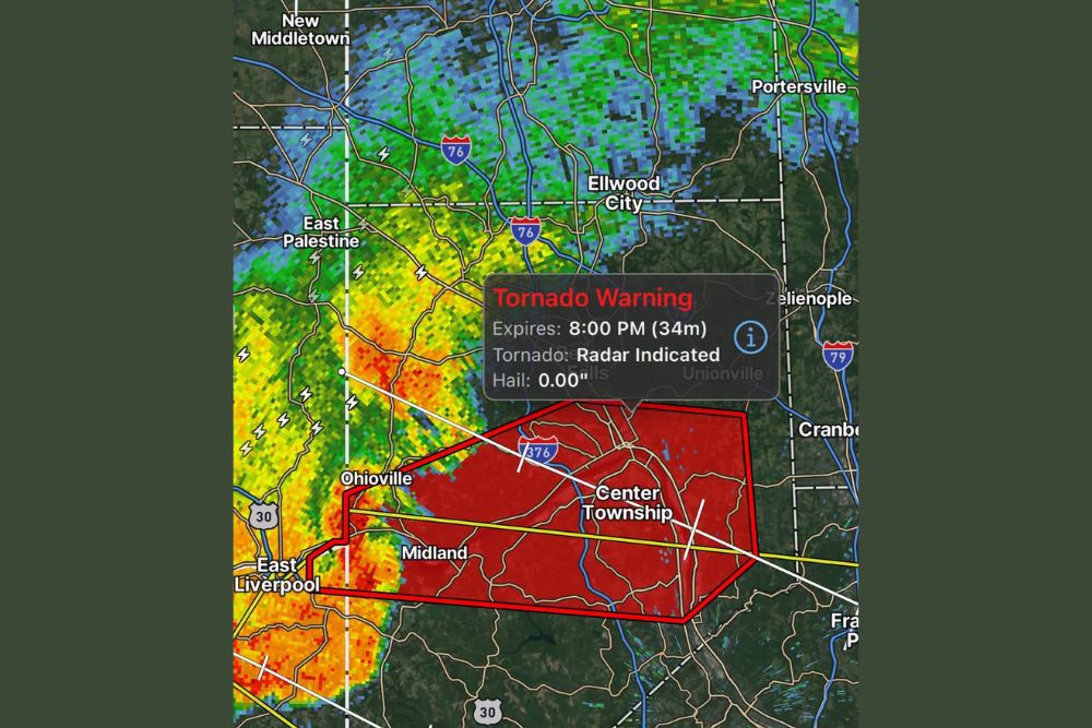
MIDLAND, PA — A Tornado Warning has been issued until 8:00 PM for central Beaver County, Pennsylvania, after the National Weather Service confirmed a severe thunderstorm capable of producing a tornado was located over Midland, near East Liverpool, at 7:24 PM. Radar has detected rotation within the storm, meaning a tornado could develop at any time as the system continues moving east at 30 mph.
Radar Confirms Rotation Within the Storm
The National Weather Service confirmed that radar imagery has detected rotation within the severe thunderstorm currently tracking through the Ohioville and Midland area, a signature that indicates the storm has the internal structure necessary to potentially produce a tornado. As of 7:24 PM, the storm was positioned over Midland, near the East Liverpool area along the Pennsylvania-Ohio border, continuing its eastward movement at approximately 30 mph.
This radar-indicated rotation is why the warning specifically states that a tornado could develop at any time, even though a tornado has not yet been visually confirmed on the ground. The warning display associated with this storm identifies the tornado threat as radar indicated, reflecting this detected rotation within the parent thunderstorm.
Wide Swath of Beaver County Communities in the Path
The Tornado Warning covers numerous communities across Beaver County, including Aliquippa, Monaca, Economy, Ambridge, New Brighton, Beaver, Baden, Rochester, Ohioville, Harmony Township, Midland, Industry, Shippingport, Patterson Township, Conway, Freedom, and Bridgewater, along with surrounding communities. That extensive list reflects the size of the warning polygon issued for this particular storm as it tracks across the county.
The warning area extends from near East Liverpool and Ohioville in the west through Midland and Center Township, with the storm’s continued eastward motion placing additional communities at risk as the system progresses along its projected path through the warned period.
Officials Urge Immediate Shelter
The National Weather Service issued a direct call to action for anyone within the warned area: take cover now. Residents were instructed to move immediately to a basement or an interior room on the lowest floor of a sturdy building, staying away from windows during the duration of the warning. Anyone outdoors, in a mobile home, or in a vehicle was urged to get to the nearest substantial shelter immediately and protect themselves from flying debris.
Officials emphasized that residents should not wait to see or hear a tornado before taking protective action, given that the radar-indicated rotation means a tornado could develop and touch down with very little additional warning time once conditions become favorable.
Potential Impacts From Flying Debris
Authorities specifically warned that flying debris associated with this storm can be deadly, and that damage to trees, roofs, windows, vehicles, and mobile homes is possible if a tornado does develop within the warned storm. That warning underscores the seriousness with which officials are treating the radar-indicated rotation, even in the absence of a confirmed tornado touchdown at the time the warning was issued.
The combination of radar-confirmed rotation and the storm’s continued eastward track through a densely populated stretch of Beaver County has heightened the urgency of the warning, prompting officials to stress immediate action rather than a wait-and-see approach among residents in the path.
Storm Continues Moving East Through the Warned Period
With the storm moving east at approximately 30 mph, communities farther along its projected path, including areas near Center Township and toward the Pennsylvania Turnpike corridor, should prepare for the storm’s arrival as the warning period continues through 8:00 PM. The storm’s forward speed means the window for any single community to prepare before the storm’s arrival remains relatively short.
Residents throughout Beaver County are encouraged to continue monitoring official alerts and local weather updates as this warning remains active, given the potential for rapid changes in the storm’s intensity or structure as it continues its eastward track through the warned area.
What Comes Next
The Tornado Warning remains in effect until 8:00 PM for central Beaver County, and officials will continue monitoring radar data for any further indications of tornado development as the storm progresses. Residents across the warned communities should remain in a place of shelter until the warning expires or until local officials indicate it is safe to resume normal activity.
For continuing coverage of severe weather events and critical storm analysis across the United States, visit svhsnow.com.