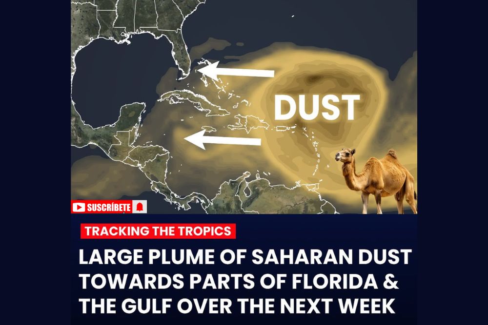
MIAMI, FL — A large plume of Saharan dust is on the way toward the Caribbean, parts of Florida, and the Gulf heading into this weekend and continuing into next week, adding another chapter to what has already become one of the quietest stretches of Atlantic hurricane activity in decades. Forecasters say the combination of repeated Saharan dust outbreaks and a powerful strengthening El Nino has helped produce the lowest tropical activity the Atlantic has seen in at least 76 years, dating back to 1950.
Dust Plume Stretches Across the Caribbean and Gulf
Satellite tracking shows the dust plume extending across a massive stretch of the tropical Atlantic, covering the Caribbean Sea and pushing toward Florida and the Gulf of Mexico as it continues moving westward over the coming days. The dry, dusty air originating from the Sahara Desert in North Africa is expected to blanket the region through the weekend and persist into next week, based on current forecast tracking.
This latest outbreak continues a pattern that has repeated multiple times throughout the 2026 Atlantic hurricane season, with successive rounds of Saharan dust playing a significant role in suppressing tropical development across the basin during what would typically be its most active stretch of the year.
An Unusually Quiet Hurricane Season by Historical Standards
The current stretch of inactivity has pushed the 2026 Atlantic hurricane season to its least active start in at least 76 years, according to the latest data cited by forecasters. That benchmark stands out significantly given that the basin is now approaching its climatological peak, the point in the season when hurricane activity typically ramps up most dramatically.
Multiple factors have combined to produce this historically quiet stretch, but forecasters have consistently pointed to the twin influences of repeated Saharan dust outbreaks and a rapidly strengthening El Nino as the primary drivers behind the suppressed activity this year.
El Nino’s Role in Suppressing Storm Development
A powerful and intensifying El Nino pattern in the tropical Pacific has been a dominant factor limiting Atlantic hurricane activity throughout the season, as El Nino conditions typically increase wind shear across the tropical Atlantic. That increased wind shear works against tropical storm formation and intensification by disrupting the vertical structure storms need to organize and strengthen.
The current El Nino has continued to strengthen through the summer months, and its influence is expected to remain a significant factor suppressing tropical activity for the remainder of the season, working in tandem with periodic dust outbreaks like the one currently spreading across the Caribbean and Gulf.
No Tropical Development Expected in the Next Week
Adding to the quiet outlook, forecasters indicated that no tropical development is expected anywhere in the Atlantic basin over the next seven days, extending the current lull even as the region moves deeper into what is traditionally the most active period of the hurricane season. That short-term forecast aligns with the broader pattern of suppressed activity that has defined the season so far.
The combination of the incoming Saharan dust plume and the continuing influence of El Nino suggests the quiet stretch is likely to persist for at least the coming week, offering continued, if temporary, relief for coastal communities that would otherwise be on heightened alert during this point in the season.
What the Dust Plume Means for Air Quality and Sunsets
Beyond its role in suppressing tropical development, the incoming Saharan dust plume is also likely to bring the visual and air quality effects commonly associated with these events, including hazy skies and vibrant, more colorful sunsets across affected areas of Florida and the Gulf Coast. Residents with respiratory sensitivities are often advised to take precautions during periods of elevated dust concentration, as the fine particulate matter can affect air quality in the region.
These effects typically become most noticeable as the bulk of the dust plume moves overhead, generally coinciding with the timeframe forecasters have outlined for this weekend into next week across the Caribbean, Florida, and Gulf Coast region.
Looking Ahead as the Season Continues
With the Atlantic hurricane season now approaching its historical peak amid one of its quietest stretches in more than seven decades, forecasters continue to monitor both the ongoing Saharan dust activity and the strengthening El Nino for any signs of change in the pattern. For now, the data points toward continued suppressed activity, with no tropical development expected through at least the next week as the dust plume works its way across the region.
Residents across the Caribbean, Florida, and Gulf Coast are encouraged to remain prepared regardless of the currently quiet pattern, since hurricane season conditions can shift, even during years marked by historically low activity.
For continuing coverage of severe weather events and critical storm analysis across the United States, visit svhsnow.com.