ST. LOUIS, MO — A couple of rounds of heavy rain and storms are likely tonight across portions of Illinois, Missouri, and Indiana, with forecasters warning that a few storms could become strong, bringing gusty winds and small hail along with the potential for 1 to 4 inches of rain where the heaviest bands set up. Rain is expected to begin around 1 AM tonight and continue on and off until roughly 5 PM Thursday, when much cooler and drier air behind the storm front will finally clear conditions out.
Multiple Rounds of Showers and Storms Expected
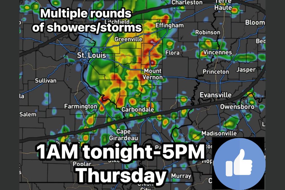
Radar data shows an extensive area of showers and thunderstorms already developing across the region, with the most intense activity currently concentrated in a corridor stretching from near Greenville and Effingham in Illinois southward through Mount Vernon and toward Carbondale and Cape Girardeau. This initial round represents just the first of multiple waves expected to move through the area between 1 AM tonight and 5 PM Thursday.
The multi-round nature of this system means that some communities positioned along the primary axis of the heaviest activity could see repeated rounds of rain pass over the same location, a scenario that raises the potential for the higher end of the forecast rainfall range in those specific areas.
Heaviest Rainfall Concentrated Along a Central Corridor
Forecast and radar data point to the heaviest rainfall totals developing along a corridor running roughly from St. Louis and Farmington in Missouri eastward through Mount Vernon, Effingham, and toward Vincennes in Illinois and Indiana. Communities within this zone are those most likely to see the higher end of the 1 to 4 inch rainfall range forecast for tonight and tomorrow.
Areas farther from this central corridor, including communities near Evansville, Owensboro, and Madisonville, are still expected to see meaningful rainfall from the multiple rounds of storms, though likely at lower totals compared to the more concentrated heavy rain zone farther north and west.
A Few Storms Could Turn Strong
While the primary story with this system is the multiple rounds of rain, forecasters cautioned that a few of the storms embedded within this activity could become strong, capable of producing gusty winds and small hail. That elevated intensity potential means residents across the affected region should treat this as more than just a routine rain event, particularly during any individual round that intensifies as it moves through.
The combination of repeated rounds of rain with the potential for occasional stronger storms creates a scenario where impacts could vary significantly from one location to the next, depending on which specific storms track directly overhead during the roughly 16-hour window this system is expected to affect the region.
Rain Continues On and Off Through Thursday Afternoon
Forecasters indicated that rain will continue on an on-and-off basis throughout the overnight hours and into Thursday, rather than clearing out quickly after the initial round passes. That extended timeline, running from 1 AM tonight until approximately 5 PM Thursday, reflects the multi-wave structure of this weather system as it works through the region.
This prolonged period of unsettled weather means residents should not expect a single, brief window of rain, but rather an extended stretch where showers and storms remain a possibility across much of Thursday before conditions finally begin to improve later in the day.
Much Cooler and Drier Air Arrives Behind the Front
Once the storm front finally clears the region around 5 PM Thursday, forecasters say much cooler and drier air will move in behind it, bringing a notable improvement in conditions following the extended period of rain. That shift represents a welcome change for a region that will have endured more than 16 hours of on-and-off precipitation by the time the system finally exits.
The arrival of this cooler, drier air mass also suggests that Thursday evening and beyond should offer a noticeable contrast to the humid, unsettled conditions associated with the overnight and daytime rain, giving residents across Illinois, Missouri, and Indiana a clear signal that the wettest portion of this event has passed.
What Residents Should Expect
Residents across the affected region should prepare for an extended period of on-and-off rain and thunderstorms beginning in the early morning hours and continuing through much of Thursday, with the potential for locally heavy totals reaching 1 to 4 inches in areas that see multiple rounds pass through. Given the potential for a few storms to become strong, residents should also stay alert for gusty winds and small hail during any particularly intense rounds that develop.
For continuing coverage of severe weather events and critical storm analysis across the United States, visit svhsnow.com.