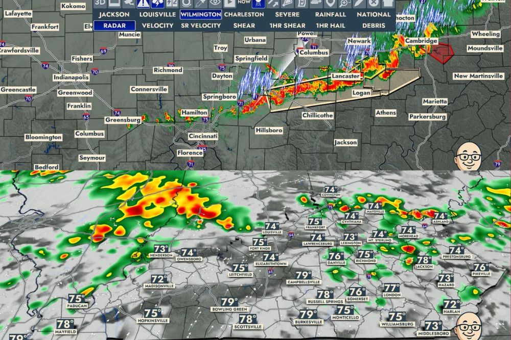
COLUMBUS, OH — A round of thunderstorms fired up just north of the Kentucky border on Wednesday night, with radar showing an active line of storms tracking across central Ohio by 9:50 PM. Forecasters say this initial round is only the beginning, with additional rounds of rain and thunderstorms expected to develop overnight and continue into the early morning hours on Thursday across the broader region.
Initial Storm Line Tracks Through Central Ohio
Radar imagery from Wednesday at 9:50 PM shows an organized line of storms stretching from near Springboro and Hamilton eastward through Springfield, Columbus, and Newark, with the most intense activity concentrated along a corridor extending toward Lancaster, Logan, and Cambridge. A severe thunderstorm warning appears to be in effect for portions of the area near Cambridge, based on the warning polygon visible on radar.
This initial line represents the first wave of what forecasters describe as a multi-round overnight event, with the current storms serving as the leading edge of a larger system expected to continue producing rain and thunderstorms well into the early morning hours.
Additional Rounds Expected Overnight
Forecast model data extending into the overnight hours shows additional rounds of storms developing and tracking across the region, with the next wave expected to take shape by Thursday at 4:30 AM. This second round shows storm activity concentrated across a wide swath of Kentucky and southern Indiana, suggesting the overnight period will bring continued unsettled weather rather than a lull following the initial line that fired north of Kentucky.
The multi-wave nature of this system is consistent with a broader area of instability and available moisture supporting repeated rounds of convection through the night, a pattern that can produce locally heavier rainfall totals in areas that see multiple rounds pass over the same location.
Third Round Develops by Early Thursday Morning
Forecast data valid for Thursday at 6:00 AM shows a third distinct round of storms developing, with activity again concentrated across portions of Kentucky and extending into the Ohio Valley region. This continued redevelopment of storm cells throughout the early morning hours suggests the overnight period will remain active across a broad stretch of the region rather than seeing storms move through in a single, clean pass.
Communities across Kentucky, including areas near Bowling Green, Scottsville, and Franklin, appear within the zone expected to see this third round of activity as the system continues to redevelop through the pre-dawn hours.
Activity Continues Into the Thursday Morning Commute
By Thursday at 8:00 AM, forecast model data shows storm activity persisting and expanding across the region, suggesting the unsettled weather pattern could extend into the Thursday morning commute for areas across Kentucky and the surrounding region. This extended timeline means residents should not expect a quick end to the overnight storm activity, as the system continues generating new rounds well past sunrise.
The persistence of storm development across multiple forecast time frames, from the initial 9:50 PM line through the 8:00 AM period, illustrates how active and prolonged this overnight weather event is expected to be for the broader Ohio Valley and Kentucky region.
What Residents Should Expect Overnight
Residents across central and southern Ohio, as well as into Kentucky and southern Indiana, should prepare for multiple rounds of rain and thunderstorms continuing through the overnight hours and into Thursday morning. The repeated nature of this activity raises the potential for locally heavier rainfall totals in areas that see several rounds of storms track over the same location during the night.
Given the active radar picture already in place by Wednesday evening and the additional rounds shown developing through Thursday morning, residents in the affected region are encouraged to stay weather-aware overnight, particularly if traveling during the early morning hours when storm activity is expected to still be ongoing.
For continuing coverage of severe weather events and critical storm analysis across the United States, visit svhsnow.com.