OKLAHOMA CITY, OK — A significant cold front is forecast to sweep southward across the central United States on Thursday afternoon, bringing a sharp 10 to 25 degree temperature drop along with the potential for much-welcomed storms across Texas, Oklahoma, Missouri, and Arkansas. Latest forecast data continues to support the dramatic swing, with temperatures expected to fall from record-challenging heat in the 100s into a far more seasonal range of the 80s and 90s as the front slowly pushes south.
A Dramatic Cool-Down Takes Shape Across the Plains
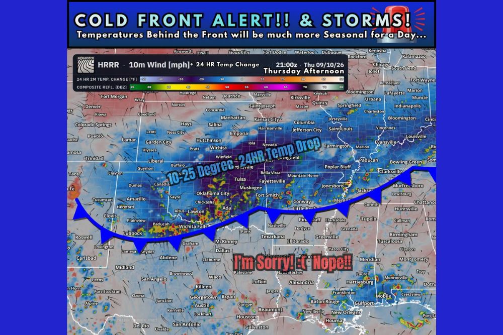
Forecast model data shows the cold front’s associated 10 to 25 degree, 24-hour temperature drop taking shape across a wide swath of the Southern and Central Plains by Thursday afternoon. The steepest cooling is expected across the western portion of the front’s path, including areas stretching from Colorado and the Texas Panhandle through Oklahoma and into Kansas, where the sharpest contrast between record heat and the incoming cooler air mass is forecast.
Wind data associated with the frontal boundary shows the telltale signature of a strong front actively displacing hot, dry air with a comparatively cooler and more seasonal air mass moving in from the north and northwest.
Storms Accompany the Front’s Passage
Alongside the temperature drop, forecasters are also tracking the potential for storms to develop along and ahead of the front as it moves through the region on Thursday. Radar simulation data for Thursday afternoon shows scattered storm activity developing across portions of Oklahoma, including areas near Tulsa, Muskogee, and Fort Smith, as the boundary interacts with available moisture in the atmosphere.
These storms, while not expected to be widespread or particularly severe, represent a welcome bonus for a region that has endured an extended stretch of hot, dry conditions, offering the possibility of at least some beneficial rainfall alongside the incoming cooler air.
Highs Drop From Record Heat Into a Seasonal Range
The most significant impact for residents will be the shift away from record-challenging heat in the 100s that has gripped portions of Texas and Oklahoma in recent weeks. Behind the front, forecasters expect highs to fall into a far more typical range for this time of year, generally landing in the 80s and 90s during the Thursday afternoon hours across areas that see the front clear through.
That shift represents a meaningful, if temporary, break from what has been an unusually intense and prolonged period of heat across the Southern Plains, offering residents from Amarillo to Little Rock a chance to experience more typical early-to-mid September conditions.
Front’s Reach Extends Across Four States
As the boundary continues its push southeastward through Thursday, forecast data shows the front’s influence extending across a broad geographic area, encompassing Texas, Oklahoma, Missouri, and Arkansas. Communities along that path, including Wichita Falls, Springfield, and Little Rock, are expected to see the front’s cooling effects arrive at various points throughout the day as the system tracks southeastward.
The broad reach of this front, spanning four states in a single afternoon, illustrates the scale of the air mass change taking place, even as forecasters emphasize that the cooler conditions are not expected to represent a permanent shift in the overall seasonal pattern.
Not the Only Cold Front Being Tracked
Forecasters were clear that Thursday’s system is not the only cold front currently being monitored, noting that a potentially stronger front may move into the region as soon as next week. That additional system suggests Thursday’s cooldown could be the first in a series of boundaries working to gradually transition the region away from the intense summer heat that has defined much of the season.
This ongoing pattern of successive cold fronts moving through the Plains and Mid-South is a typical feature of early-to-mid September as the jet stream begins its seasonal shift, even though any individual front’s cooling effects, as forecasters noted, may only last for a day or so before temperatures start trending back upward.
What Residents Should Expect
Residents across Texas, Oklahoma, Missouri, and Arkansas should prepare for a noticeably cooler and potentially stormy Thursday afternoon as the front moves through, with the most dramatic temperature swings occurring in areas that transition directly from record heat into the cooler air mass within the highlighted 24-hour window. Given the possibility of an even stronger front arriving next week, this may be just the beginning of a broader shift away from summer heat across the region.
Continued monitoring of both this front’s timing and any updates on the potentially stronger system tracked for next week will be important as forecasters refine the outlook in the coming days.
For continuing coverage of severe weather events and critical storm analysis across the United States, visit svhsnow.com.