MARBLEMOUNT, WA — A thunderstorm rolled through the Upriver Skagit region of Washington State Friday evening, producing more than 50 lightning strikes as it tracked westward from Newhalem past Marblemount and toward Rockport, with the storm also delivering what may prove to be beneficial rainfall to the ongoing Electric Fire burning near Bacon Creek Road along the Ross Lake National Recreation Area boundary.
An Active Evening in the North Cascades
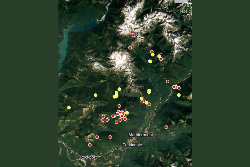
As of 6:07 PM, lightning detection data showed a dense cluster of strikes concentrated across the rugged terrain surrounding the Skagit River corridor, with the highest concentration of activity mapped in the mountainous areas north and east of Marblemount and Corkindale. The storm’s westward movement carried it directly along the path connecting Newhalem, a small community situated deep within the North Cascades, through Marblemount, and continuing toward Rockport near the confluence of the Skagit and Sauk Rivers.
Lightning Data Reveals the Storm’s Intensity
The mapped lightning strikes, shown as a mix of red and yellow markers indicating strike timing and intensity, revealed a storm system with sustained electrical activity across a wide stretch of rugged, forested terrain. This kind of mountain thunderstorm activity is common across the North Cascades during periods of daytime heating combined with sufficient atmospheric moisture and instability, conditions that can develop relatively quickly over the complex terrain of the region before tracking along established drainage corridors like the Skagit River valley.
The concentration of strikes near the higher terrain surrounding Ross Lake and the peaks north of Marblemount reflects a pattern often seen in mountain thunderstorms, where orographic lifting, the forced rising of air as it moves over elevated terrain, helps trigger and sustain thunderstorm development even in areas removed from more typical severe weather corridors.
Beneficial Rain Reaches the Electric Fire
Perhaps the most consequential aspect of Friday evening’s storm for the surrounding region was the rainfall it appears to have delivered to the area of the Electric Fire, an active wildfire burning near Bacon Creek Road close to the boundary of the Ross Lake National Recreation Area. While the exact rainfall totals in the immediate fire area were not specified, any meaningful precipitation reaching an active fire zone can help firefighting efforts by increasing fuel moisture and potentially slowing fire spread and intensity, even if the rain itself is not sufficient to fully extinguish the blaze.
Wildfires burning in remote, mountainous terrain like the area surrounding Bacon Creek Road often present significant access challenges for ground crews, making any natural precipitation assistance particularly valuable in supplementing firefighting operations already underway in the area.
Lightning’s Double-Edged Role Near Active Fires
Thunderstorms moving through areas with active wildfires present a complicated dynamic for fire managers. While rainfall associated with a storm can provide beneficial moisture that aids suppression efforts, the lightning accompanying that same storm carries the risk of igniting additional new fire starts in nearby dry fuels, particularly in areas that have not yet received the storm’s rainfall. Fire managers monitoring the Electric Fire will likely be watching closely in the storm’s aftermath for any signs of new lightning-caused ignitions in the surrounding forest, even as they welcome whatever rainfall the system managed to deliver directly onto the existing fire.
What Comes Next for the Region
With the storm continuing its westward track through the evening, residents and fire crews across the Upriver Skagit region are expected to continue monitoring both the fire’s behavior and any additional thunderstorm activity that may develop in the area. The interaction between mountain thunderstorms and active wildfire behavior remains an important factor for fire officials managing the Electric Fire as conditions continue to evolve heading into the weekend.
For continuing coverage of severe weather events and critical storm analysis across the United States, visit svhsnow.com.