WILMINGTON, NC — Weather conditions across most of North Carolina settled into a much quieter pattern late Saturday night, with radar showing only isolated pockets of thunderstorm activity remaining offshore near the Outer Banks and off Brunswick County, while the vast majority of the state stayed calm.
A Calmer End to an Active Day
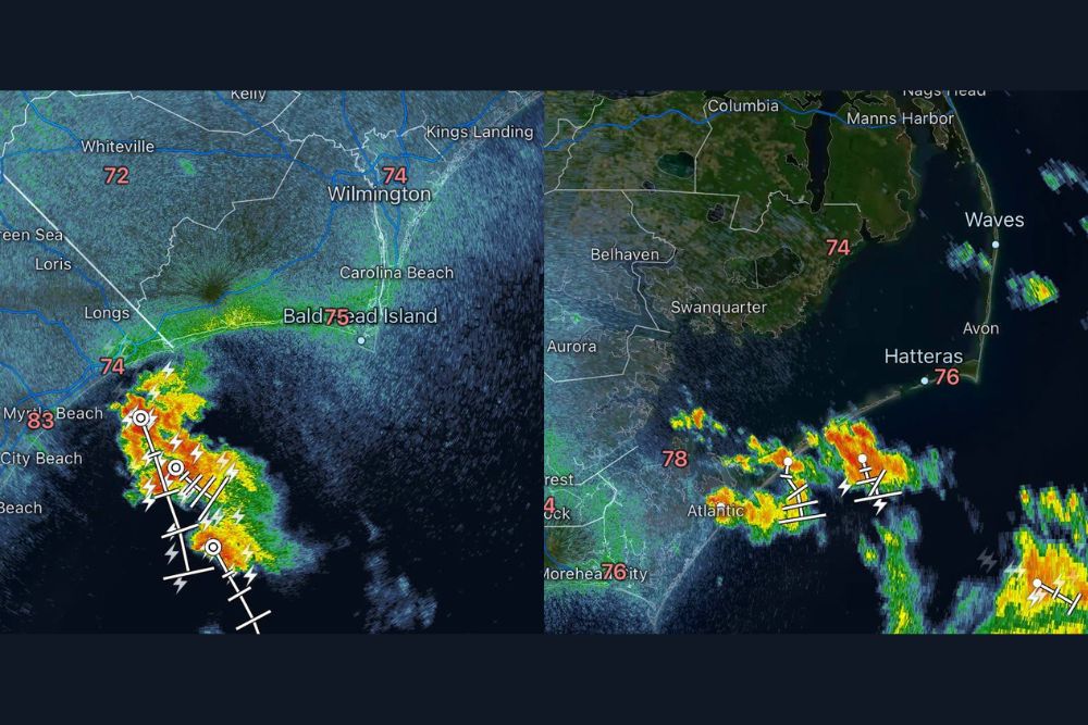
Radar imagery from late Saturday night showed the bulk of North Carolina’s earlier storm activity had largely cleared out, leaving behind only a couple of lingering areas of thunderstorms positioned well offshore. One cluster of storms remained active near Bald Head Island and stretching south toward Myrtle Beach, with radar showing intense cores of heavy precipitation and embedded lightning continuing to affect coastal waters off Brunswick County even as inland areas had returned to quiet conditions.
Outer Banks Sees Continued Isolated Activity
Farther northeast along the coast, a separate area of thunderstorm activity persisted near the Outer Banks, with radar showing scattered storms tracking across the waters off Hatteras, Avon, and Waves. These storms appeared similarly confined to the immediate coastal and offshore waters, with temperatures in the region holding in the mid-to-upper 70s, including a reading of 78 degrees near Atlantic and 76 degrees at both Hatteras and Morehead City.
The persistence of these two separate pockets of activity, one near Brunswick County and the other near the Outer Banks, reflects a common late-summer pattern along the North Carolina coast, where daytime heating and abundant moisture off the Atlantic can sustain isolated thunderstorm activity well into the overnight hours even as the broader statewide pattern quiets down considerably.
Inland North Carolina Returns to Calm
Away from these two coastal pockets of lingering activity, the rest of North Carolina had returned to notably quiet conditions by late Saturday night. Temperatures across the region remained warm and muggy, with readings including 83 degrees in Myrtle Beach, 75 degrees at Bald Head Island, and 74 degrees in both Wilmington and Kings Landing, reflecting the lingering warmth and humidity typical of early September evenings along the Carolina coast even without active thunderstorm coverage overhead.
Why Coastal Storms Often Persist Longer
Thunderstorms situated directly along or just off the coastline can sometimes persist longer into the evening and overnight hours compared to storms farther inland, largely due to the interaction between land and sea breezes along with the ready supply of moisture from the adjacent ocean waters. This dynamic can allow storms to maintain themselves over coastal waters even after the atmospheric energy that fueled earlier inland storm development has largely dissipated across the mainland.
The offshore positioning of both areas of continuing storm activity Saturday night meant that while radar continued to show lightning and heavy rainfall signatures, the direct impact to populated coastal communities remained relatively limited compared to if the same storms had been tracking directly over land.
What Comes Next for North Carolina
With the bulk of the state now quiet heading toward the overnight hours, residents across North Carolina can expect a comparatively calm end to the day, though those along the immediate coast near Brunswick County and the Outer Banks should remain aware that isolated storm activity could continue to affect nearby waters into the late night hours before fully dissipating.
Meteorologists will continue monitoring the two remaining pockets of offshore activity for any signs of redevelopment or intensification as the night progresses, though the overall trend across the state points toward an increasingly quiet stretch as Saturday transitions into early Sunday.
For continuing coverage of severe weather events and critical storm analysis across the United States, visit svhsnow.com.