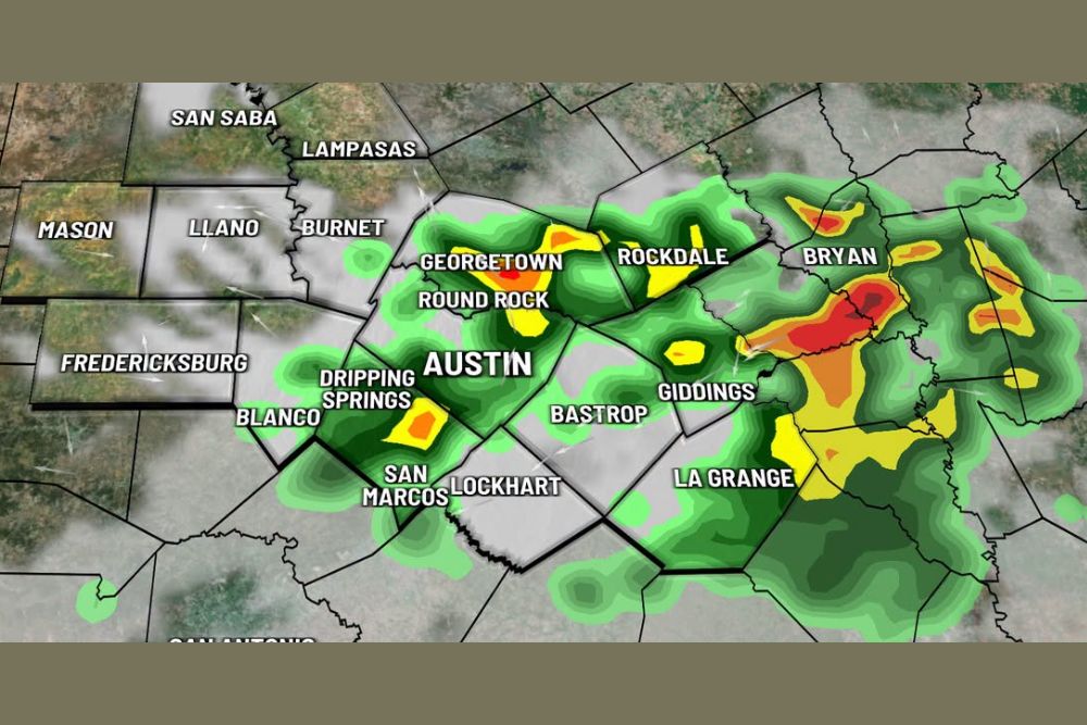
AUSTIN, TX — Increasing confidence among computer weather models has meteorologists raising rain chances across Central Texas for Sunday morning, with radar showing widespread clouds and scattered showers already spreading across the Austin metro area and surrounding counties as of 8:00 AM, including areas stretching from Georgetown and Round Rock through Bastrop and toward Bryan.
Model Confidence Grows for Morning Rain
Forecasters tracking the developing pattern noted that several computer models have been increasingly consistent in showing rainfall developing across Central Texas Sunday morning, a trend that has boosted overall confidence in at least some measure of wet weather materializing across the region as the day begins. Radar imagery captured at 8 AM already showed a broad area of light to moderate precipitation covering much of the Austin metro area, with more intense pockets of heavier rain, shown in yellow, orange, and red on the reflectivity scale, concentrated across areas east of the city toward Rockdale and Bryan.
A Complex Relationship Between Morning and Afternoon Rain
One of the more nuanced aspects of Sunday’s forecast involves how the timing of any morning rainfall could influence what happens later in the day. Forecasters explained that if rain does materialize during the morning hours as the models increasingly suggest, afternoon rain chances would actually be lower, since morning precipitation often stabilizes the atmosphere and reduces the instability needed to fuel new thunderstorm development later on.
Conversely, should the morning stay dry across the region, forecasters indicated there would be a correspondingly higher chance for afternoon thunderstorms to develop as the day’s heating builds sufficient instability in the absence of any earlier rain-driven stabilization. This kind of either-or relationship between morning and afternoon precipitation chances is a common feature of Texas weather patterns during the warm season, where the timing of one round of activity can significantly shape the potential for another later in the same day.
Afternoon Thunderstorm Chances Raised to 30 Percent
Given the uncertainty surrounding exactly how the morning setup will play out, forecasters have raised the chance for afternoon thunderstorms to 30 percent across the Central Texas region. That figure reflects a meaningful, though not overwhelming, likelihood of additional shower and thunderstorm activity developing later Sunday, particularly in scenarios where the morning remains largely dry and allows for greater afternoon instability to build across the area.
Communities across the broader Austin metro region, including Georgetown, Round Rock, Dripping Springs, San Marcos, and Lockhart, along with areas farther east like Bastrop, Giddings, and La Grange, all fall within the zone where this afternoon storm potential remains in play depending on how the morning’s rainfall ultimately unfolds.
Radar Shows Rain Already Spreading Sunday Morning
The 8 AM radar snapshot showed rain already well underway across a significant portion of Central Texas, with the heaviest and most organized precipitation positioned to the northeast of Austin, closer to Rockdale and Bryan, where reflectivity values indicated locally heavier rainfall rates. Meanwhile, areas to the west and southwest of Austin, including Fredericksburg, Mason, and Llano, showed comparatively lighter or more scattered coverage, suggesting the heaviest rain axis was tracking somewhat east of the immediate Austin metro area during the morning hours.
What Central Texas Residents Should Expect
Given the fluid nature of Sunday’s forecast, residents across Central Texas should stay flexible with outdoor plans and continue monitoring updated forecasts throughout the day, particularly if the morning stays dry in their specific location, since that scenario carries the higher probability of thunderstorm development later in the afternoon. Areas that do see rainfall during the morning hours should see a comparatively quieter, if damper, afternoon as a result of the atmospheric stabilization that morning rain tends to produce.
Meteorologists will continue refining the forecast throughout the day as actual observed rainfall patterns provide clearer guidance on how the morning-versus-afternoon dynamic is likely to play out across the region.
For continuing coverage of severe weather events and critical storm analysis across the United States, visit svhsnow.com.