GRAND RAPIDS, MI — After a stretch of severe storms, flooding, and oppressive humidity battered the region throughout the week, Michigan welcomed a dramatic pattern change Saturday, with cooler temperatures, sunshine, and no severe weather chances bringing widespread relief across nearly the entire state.
A Welcome Break From an Active Week
The turnaround comes as a significant relief for residents across Michigan who endured repeated rounds of severe thunderstorms, flash flooding, and uncomfortably humid conditions in the days leading up to Saturday. With that unsettled pattern finally clearing out, forecasters described Saturday’s setup as bringing sweet relief in the form of drier air, more comfortable temperatures, and abundant sunshine replacing the storm clouds and humidity that had dominated the region.
Nice Day Index Shows Amazing Conditions Statewide
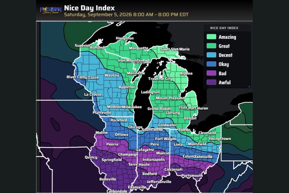
A Nice Day Index forecast covering Saturday, September 5th, from 8:00 AM to 8:00 PM Eastern Time, illustrated just how favorable conditions were shaping up across the Great Lakes region. The index, which factors in temperature, humidity, sunshine, and the absence of severe weather to rate the overall pleasantness of a given day, showed a large swath of northern and central Michigan rated as Amazing, the top category on the scale, stretching from the Upper Peninsula near Marquette and Sault Ste. Marie down through Traverse City, Alpena, and much of the northern Lower Peninsula.
Communities including Grand Rapids, Lansing, Flint, Port Huron, and Detroit fell into the Great category on the index, still representing highly favorable conditions even if just a notch below the amazing ratings farther north. This widespread stretch of green shading across the map reflected just how broadly the improved weather pattern was expected to be felt across the state.
Neighboring States See a More Mixed Picture
While Michigan enjoyed some of the most favorable conditions on the map, the picture grew more mixed farther south and west. Areas across northern Illinois, Indiana, and Ohio, including Chicago, South Bend, Toledo, and Cleveland, fell into the Decent category, still a reasonably pleasant day but not quite matching the amazing to great conditions found across most of Michigan.
Conditions deteriorated further south, with cities including Indianapolis, Springfield, Terre Haute, and Cincinnati landing in the Bad to Awful range on the index, suggesting a far less pleasant day across the southern portions of the mapped region, likely due to continued heat, humidity, or unsettled weather lingering in that zone even as Michigan enjoyed its improved pattern.
No Severe Weather Chances in the Forecast
Perhaps the most welcome aspect of Saturday’s forecast for Michigan residents was the complete absence of severe weather chances, a sharp contrast to the pattern that had produced repeated warnings, flash flooding, and extreme lightning displays across the state in the preceding days. With no severe threat in play and cooler, drier air in place, Saturday offered an opportunity for outdoor activities without the need to monitor radar or worry about rapidly developing storms.
What Made This Week So Difficult
The severe weather and flooding that preceded Saturday’s relief included multiple rounds of intense thunderstorms capable of producing damaging winds and torrential rainfall, contributing to flash flooding concerns in several communities across the state. Combined with persistently high humidity levels that made even non-stormy days feel uncomfortable, the stretch represented one of the more challenging weather periods Michigan had experienced recently, making Saturday’s improvement all the more welcome for residents across the state.
Enjoying the Improved Conditions
With cooler temperatures, sunshine, and a complete break from severe weather chances, Saturday presented an ideal opportunity for Michigan residents to get outside and take advantage of the improved pattern after a taxing stretch of active weather. Forecasters encouraged residents to make the most of the pleasant conditions while they last, particularly given how quickly the state’s weather had shifted from severe and stormy to calm and comfortable.
For continuing coverage of severe weather events and critical storm analysis across the United States, visit svhsnow.com.