TALLAHASSEE, FL — With this year’s El Nino event continuing to strengthen toward what some forecasters describe as possible record-breaking intensity, meteorologists and weather watchers are increasingly discussing what an active El Nino fall and winter could mean for Florida and the broader South and East. Historically, strong El Nino patterns have been associated with a more active storm season for the region, driven largely by a strengthened Pacific jet stream that fuels frequent storm systems across the southern United States.
The Pacific Jet Stream’s Role in Florida’s Weather
During strong El Nino winters, a more pronounced and southward-shifted Pacific jet stream tends to develop, channeling a steady stream of Pacific storm systems across the southern tier of the country and into Florida. That enhanced jet stream activity is the mechanism behind many of the notable weather events Florida has experienced during past El Nino winters, ranging from heavy rainfall to unusual cold outbreaks and even severe weather outbreaks during the cooler months.
This pattern differs from typical La Nina or neutral winters, when the jet stream tends to sit farther north, generally sparing Florida from the same frequency of storm systems moving through the state during the fall and winter months.
A History of Notable El Nino Winters in Florida
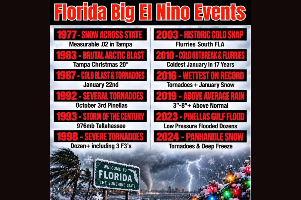
Florida’s history includes numerous standout weather events tied to past El Nino winters, illustrating just how varied the impacts can be. The winter of 1977 brought measurable snow to the state, including 0.02 inches recorded in Tampa, an extraordinarily rare occurrence for the Sunshine State. Just six years later, the winter of 1983 delivered a brutal arctic blast that pushed Tampa’s Christmas Day temperature down to 20 degrees.
The El Nino winter of 1987 brought both a significant cold blast and tornado activity on January 22nd, while 1992 saw several tornadoes touch down, including activity in Pinellas County on October 3rd. The 1993 El Nino winter is remembered for the Storm of the Century, a historic system that produced a 976 millibar pressure reading in Tallahassee, among the lowest ever recorded for a winter storm in the region. That same El Nino cycle also brought severe tornado activity in 1998, including more than a dozen tornadoes, three of which reached F3 intensity.
More Recent El Nino Winters Show Continued Volatility
The pattern of significant weather events during El Nino winters has continued into more recent years. The winter of 2003 brought a historic cold snap with flurries reported across South Florida, while 2010 delivered another significant cold outbreak accompanied by flurries, contributing to what was recorded as the coldest January in 17 years at the time.
2016 stood out as the wettest El Nino winter on record for parts of Florida, combining tornado activity with January snowfall, while 2019 brought above-average rainfall across the state, with some areas recording 3 to 8 inches or more above normal totals. More recently, the 2023 El Nino winter produced significant flooding in Pinellas County tied to a slow-moving area of low pressure that flooded dozens of properties, and 2024 brought both tornadoes and a deep freeze to the Florida Panhandle, along with rare panhandle snowfall.
What This Year’s Strong El Nino Could Mean
Given the historical pattern associated with strong El Nino winters, meteorologists are watching this year’s rapidly intensifying event with particular interest, as current data suggests it could rank among the more significant El Nino episodes on record. If the historical relationship holds, Florida and the broader South and East could see an active fall and winter season, potentially featuring some combination of the heavy rainfall, severe weather, and even unusual cold outbreaks that have characterized past strong El Nino years.
Forecasters caution that no two El Nino events produce identical outcomes, and the specific timing, location, and intensity of any weather impacts this fall and winter will depend on how the broader atmospheric pattern evolves in the coming months as the event continues to strengthen.
Looking Ahead to an Active Season
As the current El Nino event continues its rapid intensification through the remainder of the year, residents across Florida and the greater South and East are encouraged to stay informed as forecasters continue monitoring how this year’s pattern compares to the historic events of 1977, 1983, 1987, 1992, 1993, 1998, 2003, 2010, 2016, 2019, 2023, and 2024. The list of past events serves as a reminder of the wide range of impacts a strong El Nino winter can bring to the state.
Continued updates on the strength and trajectory of this year’s El Nino will help refine expectations for the fall and winter season as more data becomes available in the coming weeks and months.
For continuing coverage of severe weather events and critical storm analysis across the United States, visit svhsnow.com.