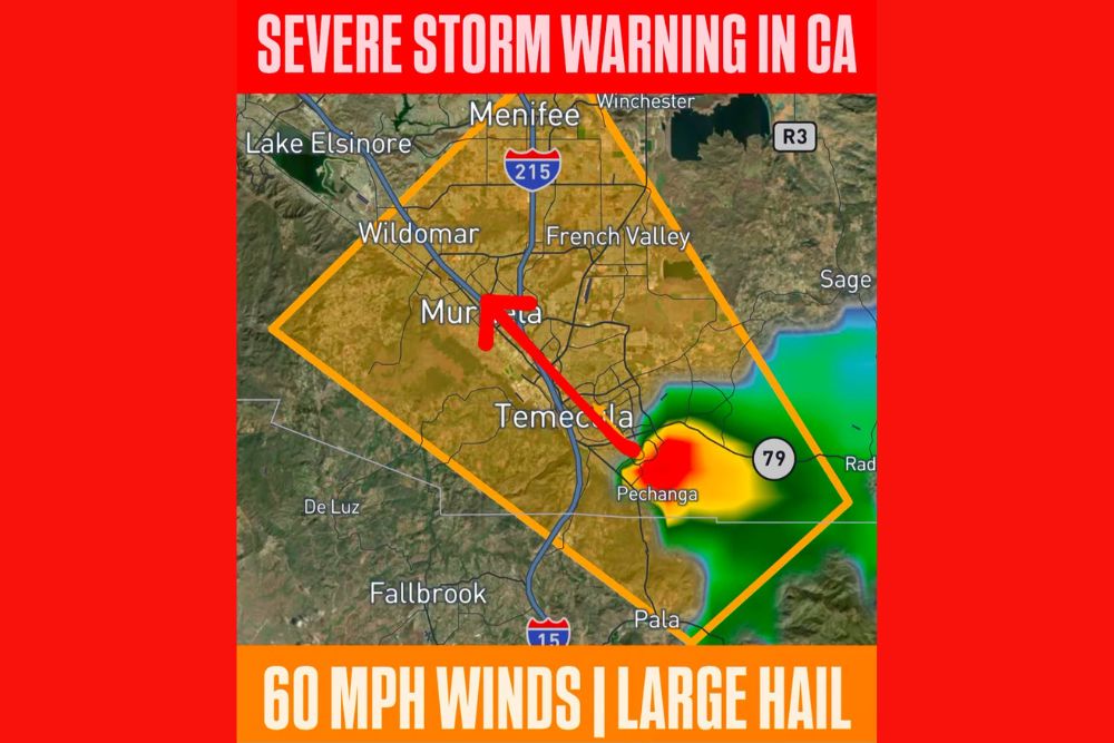
MURRIETA, CA — A Severe Thunderstorm Warning has been issued for parts of San Diego and Riverside Counties in California, including the communities of Murrieta, Temecula, and Wildomar, remaining in effect until 6:15 PM PDT. The National Weather Service confirmed the storm is capable of producing damaging winds up to 60 mph and large hail, prompting officials to urge residents across the warned area to take shelter immediately as the storm continues moving through the region.
Storm Tracks Northwest Through the Warned Area
Radar data shows the strongest core of the thunderstorm currently positioned near Pechanga and Highway 79, with the most intense reflectivity readings indicating the area experiencing the heaviest rain and largest hail at this time. The storm’s motion is tracking generally northwest, placing communities including Temecula and Murrieta directly in the path of the approaching cell as it continues its trajectory.
The warning polygon stretches from near Lake Elsinore and Menifee in the north down through Fallbrook and Pala to the south, covering a wide swath of inland Southern California communities along the Interstate 15 corridor.
Damaging Winds and Large Hail Pose Immediate Threats
The National Weather Service specifically highlighted 60 mph wind gusts as a primary hazard associated with this storm, a speed capable of downing tree limbs, damaging roofing material, and making driving hazardous for anyone caught on area roadways during the peak of the storm. Combined with the wind threat, large hail was also confirmed within the storm, raising the risk of damage to vehicles, windows, and outdoor property across the warned communities.
The combination of damaging wind and large hail within the same warned storm cell represents a compound severe weather threat, one that officials say warrants immediate shelter for anyone in the direct path rather than attempting to wait out the storm outdoors or in a vehicle.
Communities Along the I-215 and I-15 Corridors Affected
Communities positioned along the Interstate 215 corridor, including Winchester, French Valley, and Menifee, fall within the warned area as the storm continues its track through the region. Farther south along Interstate 15, Temecula and areas approaching Fallbrook and Pala are also included within the boundary of the warning, extending the potential impact zone across a significant stretch of inland Riverside and San Diego County terrain.
The warned area’s proximity to major highway corridors raises particular concern for travelers, as sudden reductions in visibility from heavy rain combined with the potential for large hail and gusty winds can create hazardous driving conditions with little advance notice.
Storm Fits Pattern of Late Summer Monsoonal Activity
Severe thunderstorms of this nature are not uncommon across inland Southern California during the late summer months, when monsoonal moisture pushing in from the south and east interacts with daytime heating to produce strong to severe thunderstorm development over the region’s mountains and valleys. These storms can develop and intensify quickly, often catching residents off guard given the relative rarity of severe weather warnings in coastal and inland Southern California compared to other parts of the country.
The storm currently affecting Murrieta, Temecula, and Wildomar appears consistent with that seasonal pattern, developing rapidly enough to prompt a formal warning from the National Weather Service given the confirmed damaging wind and hail threat.
What Residents in the Warned Area Should Do
Residents and anyone traveling through the warned portions of San Diego and Riverside Counties were urged to seek sturdy shelter immediately and to avoid being outdoors or in vehicles until the storm has passed through their location. The warning remains in effect until 6:15 PM PDT, giving residents a defined window during which the most significant threat from wind and hail is expected.
Officials continue to monitor the storm’s evolution as it tracks northwest, with the potential for additional warnings if new cells develop or if the current storm maintains or strengthens its intensity as it moves through the remainder of the warned area.
For continuing coverage of severe weather events and critical storm analysis across the United States, visit svhsnow.com.