ATLANTA, GA — Long-range weather models are beginning to hint at a possible pattern change that could bring meaningfully cooler weather and below-normal temperatures across North Georgia and much of the Eastern United States, with meteorologists eyeing a potential shift sometime around September 20th, though forecasters caution the signal remains a developing one worth watching rather than a locked-in certainty.
Temperature Departure Map Shows a Striking East-West Split
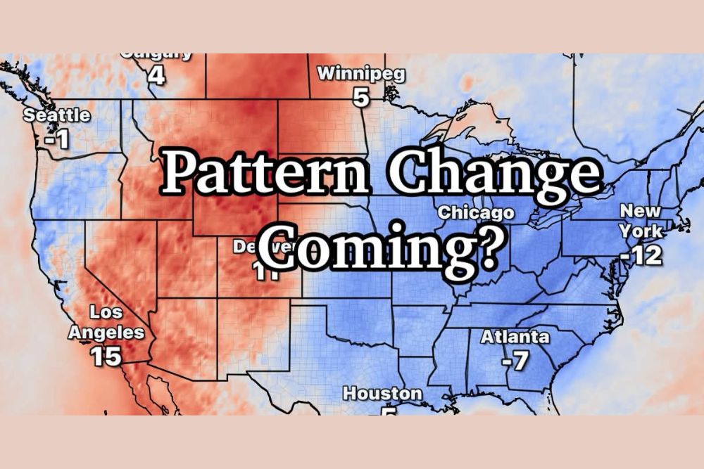
Long-range model output illustrating potential temperature departures from normal reveals a dramatic contrast between the eastern and western United States. Much of the East Coast and interior Eastern states, shown in shades of blue indicating below-normal temperatures, include projected departures of -12 degrees in New York, -7 degrees in Atlanta, -5 degrees in Houston, and -3 degrees in Miami. Meanwhile, the western half of the country tells a very different story, with Los Angeles projected at +15 degrees above normal and Denver at +11 degrees, reflecting a pattern where warmth becomes locked in across the West while cooler air pushes into the East.
What Meteorologist Greg Majewski Is Watching
According to Meteorologist Greg Majewski, models are starting to hint at a pattern shift sufficient to bring genuinely cooler weather and below-normal temperatures specifically to the eastern United States, with North Georgia positioned to benefit from this potential cooldown. The timing currently being eyed centers around September 20th, though Majewski was careful to frame this as still a considerable distance off on the forecast timeline, a factor that inherently limits how much confidence can currently be placed in the specific details.
Why Confidence Grows as the Timeline Shrinks
A key principle guiding how meteorologists communicate this kind of long-range signal involves the relationship between forecast confidence and time. Once a potential pattern change is first identified in long-range model guidance, as appears to be happening now for the North Georgia region, confidence in that signal typically grows steadily as the actual date in question draws closer. This happens because longer-range forecasts inherently carry more uncertainty, with model guidance often shifting run to run as more current data becomes incorporated into the forecasting process.
This is why forecasters like Majewski frame a signal appearing roughly two weeks out as something to watch rather than something residents should treat as a locked-in guarantee, since the specific timing, magnitude, and geographic extent of any cooldown can and often does change considerably as the forecast period approaches.
A Sharp Contrast Between East and West
The temperature departure map underscores just how significant of a pattern shift is being discussed, with the eastern half of the country trending several degrees below normal while the western United States remains locked into a substantially warmer than average pattern. This kind of east-west temperature dipole is a common feature of shifting jet stream patterns, where a trough digging into the eastern United States allows cooler air to spill southward while a ridge builds and reinforces warmth across the West.
Communities across North Georgia, along with much of the broader Southeast and Eastern Seaboard, would stand to benefit most directly from this kind of pattern shift, particularly after a stretch of weather that has featured persistent above-normal heat across much of the Southern United States in recent weeks.
What This Could Mean for North Georgia
Should this potential pattern change materialize as currently hinted at by long-range models, residents across North Georgia could see a welcome transition toward more autumn-like conditions around the September 20th timeframe, offering a meaningful break from the extended stretch of hot and humid weather that has characterized much of the late summer season across the region.
Staying Tuned as the Timeline Approaches
Given the considerable distance still remaining before the potential pattern change window arrives, meteorologists including Majewski are urging residents to treat this as an early signal worth monitoring rather than a confirmed forecast. As is typical with long-range outlooks of this nature, confidence in the specific details is expected to sharpen considerably as the September 20th timeframe draws nearer and additional model data becomes available.
For continuing coverage of severe weather events and critical storm analysis across the United States, visit svhsnow.com.