TOLEDO, OH — A Ring of Fire weather pattern is gearing up once again, and it’s about to throw northern Ohio into another round of atmospheric chaos, with forecasters describing the setup as unusually wild for late September. The region sits parked right along the edge of a stubborn high-pressure dome, exactly the spot where storm complexes tend to ride the boundary like a weather roller coaster, setting the stage for multiple rounds of potentially significant weather.
Steamy Southern Air Collides With Cooler Northern Air
The mechanism driving this active pattern involves steamy southern air slamming into cooler northern air directly along the boundary where northern Ohio currently sits. This kind of temperature and moisture contrast along a stalled boundary is a classic recipe for repeated thunderstorm development, as the atmosphere works to resolve the sharp contrast between the two competing air masses.
Multiple storm complexes are expected to fire along this boundary and track directly into the region, with forecasters noting that this pattern tends to produce a continuous parade of storm systems rather than a single, isolated event, given how favorably positioned northern Ohio is relative to the ongoing atmospheric setup.
Every Storm Complex Carries Multiple Threats
Forecasters cautioned that every single one of the expected storm complexes could bring torrential rain, raising flooding concerns across the affected region. Depending on how each individual complex organizes as it approaches, some systems could also produce severe weather, including damaging wind swaths capable of causing significant impacts wherever they track.
This combination of heavy rain, flooding potential, and possible severe wind threats across multiple successive storm systems represents a compounding risk for northern Ohio, since each new complex arrives before the ground has necessarily had time to fully recover from the previous round of heavy rainfall.
The Active Stretch Runs From September 19 Through the 24th
Forecasters indicated this active pattern looks set to persist from September 19th through the 24th, and cautioned that the stretch of unsettled weather could potentially run even longer than that initial window. This extended timeline suggests northern Ohio should prepare for the better part of a week, or possibly more, of repeated storm threats rather than a brief, one-off weather event.
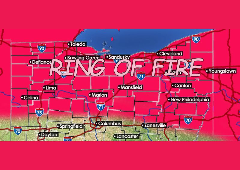
The map highlighting this Ring of Fire pattern shows the affected zone stretching across a broad swath of northern and central Ohio, including Toledo, Cleveland, Youngstown, Columbus, and Dayton, illustrating just how widespread this multi-day threat is expected to become across the region.
An Unusually Summer-Like Setup for Late September
Perhaps the most notable aspect of this outlook is just how out of season this kind of pattern actually is, with forecasters explicitly noting this is the kind of setup typically expected in July or early August, not the back half of September. This characterization underscores how unusual it is for the atmosphere to be behaving in a manner more consistent with peak summer than early fall.
Forecasters described the atmosphere as acting like it’s mid-summer again, a striking assessment that highlights just how significantly this particular pattern deviates from what residents across northern Ohio would typically expect to see as the calendar moves deeper into September and closer to the traditional start of fall.
What a Ring of Fire Pattern Typically Produces
A Ring of Fire setup, named for the tendency of storm systems to fire along the periphery of a strong high-pressure dome, is well known among meteorologists for producing repeated rounds of thunderstorm activity, often including instances of both flooding rain and severe weather. This kind of pattern can be particularly challenging to forecast precisely, since the exact track and intensity of each individual storm complex can vary considerably even while riding the same general boundary.
Given the multi-day nature of this setup, residents across the affected region should expect the potential for several distinct rounds of storms rather than a single continuous event, with each new complex carrying its own independent risk for flooding rain and possible severe weather impacts.
What Residents Should Expect
Residents across northern Ohio, including communities from Toledo and Cleveland to Columbus and Dayton, should prepare for an extended and potentially volatile stretch of weather beginning around September 19th and continuing through at least the 24th, with the possibility of the pattern persisting even longer. Given the risk of both flooding rain and severe weather with damaging winds across multiple storm complexes, residents should stay closely tuned to forecast updates as this unusually active late-September pattern unfolds.
For continuing coverage of severe weather events and critical storm analysis across the United States, visit svhsnow.com.