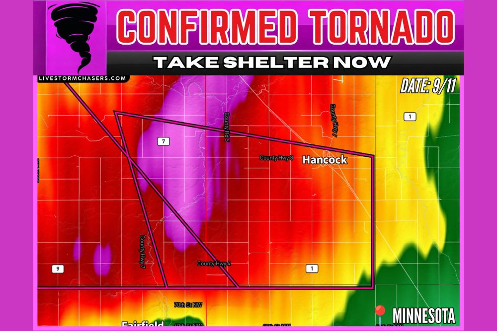
MORRIS, MN — A confirmed tornado touched down near Lake Hattie, approximately 12 miles southwest of Morris, in west central Minnesota on September 11, prompting officials to urge residents in the storm’s path to take shelter immediately. The tornado was confirmed as it continued moving southeast at 10 mph, placing communities including Hancock directly in its projected path as the storm progressed across the region.
Confirmed Tornado Tracks Through Rural Stevens County
The confirmed tornado developed within a broader severe thunderstorm tracking through Stevens County in west central Minnesota, an area characterized by rural farmland and small agricultural communities. The storm’s position near Lake Hattie, southwest of Morris, placed it within a warning polygon that extended northeast toward Hancock, capturing the tornado’s projected path as it continued its slow-moving trajectory across the county.
The relatively slow forward speed of 10 mph meant the tornado remained a threat to areas along its path for an extended period compared to faster-moving storms, giving residents in the warned zone additional time to seek shelter but also extending the window during which the tornado posed a direct threat to the area.
Radar Confirms Intense Rotation Within the Storm
Radar imagery associated with this tornado showed the kind of intense, well-defined rotational signature typically associated with confirmed tornadic activity, with areas of extreme reflectivity concentrated directly along the tornado’s path near County Highway 7 and County Road 5. The storm’s structure on radar displayed the classic hook-like formation often visible when a supercell thunderstorm is producing a tornado.
The warning polygon associated with this storm extended across a significant swath of the county, capturing both the confirmed tornado’s current location and its anticipated path as it continued moving southeast toward Hancock and the surrounding countryside.
Hancock and Surrounding Communities in the Projected Path
With the tornado moving southeast at 10 mph, the community of Hancock fell within the storm’s projected path, along with surrounding rural areas near County Highway 8 and County Highway 4. Residents in these communities were urged to take the confirmed tornado threat seriously and to seek appropriate shelter immediately given the storm’s continued movement in their direction.
The rural nature of the affected area, spanning farmland and small communities across Stevens County, meant that officials emphasized the importance of having a reliable way to receive severe weather alerts, since population density in the direct path remained relatively sparse compared to more urbanized tornado warning scenarios.
Officials Urge Immediate Shelter for Anyone in the Path
Given the confirmed nature of this tornado, officials issued a direct call to action for anyone within the storm’s path: take shelter now. Residents were advised to move to a basement or an interior room on the lowest floor of a sturdy structure, away from windows, while anyone caught outdoors, in a vehicle, or in a mobile home was urged to seek the nearest substantial shelter immediately.
The confirmed status of this tornado, as opposed to a radar-indicated or possible tornado, meant officials treated the threat with heightened urgency, since visual or other direct confirmation of the tornado removes the uncertainty sometimes associated with radar-only indications of rotation.
Broader Context Within Minnesota’s Severe Weather Pattern
Confirmed tornadoes in west central Minnesota during September are not unheard of, though they represent a less common occurrence compared to the peak severe weather season earlier in the summer months. The setup that produced this tornado near Lake Hattie appears consistent with a stronger storm system capable of producing rotating supercells even as the calendar moves further into fall.
This tornado adds to the broader pattern of severe weather activity that has affected portions of the Upper Midwest in recent weeks, underscoring that the region remains susceptible to significant severe weather threats even as the traditional summer severe weather season winds down.
What Residents Should Do
Residents across Stevens County and the broader west central Minnesota region should continue monitoring official weather alerts as this confirmed tornado and its parent storm continue moving through the area. Given the tornado’s relatively slow forward speed, communities along the storm’s path toward Hancock should remain in shelter until local officials or the National Weather Service indicate the threat has passed.
For continuing coverage of severe weather events and critical storm analysis across the United States, visit svhsnow.com.