NEW ORLEANS, LA — Nearly the entire ensemble model family is now showing signals of possible development in the Gulf of Mexico during the September 23 to 29 window, a signal forecasters say has remained remarkably consistent across successive model runs in recent days. Meteorologists tracking the trend are clear, however, that this does not guarantee a hurricane, and that the exact intensity, location, and track of any potential system remain entirely unknown at this point.
Nearly the Full Ensemble Family Shows Interest in the Gulf
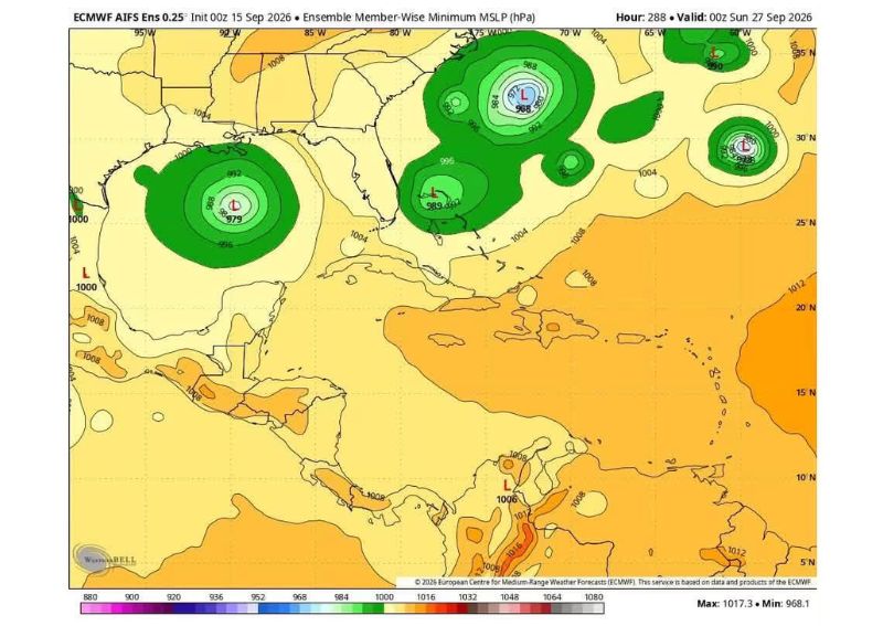
Ensemble forecast data shows numerous individual model members identifying areas of low pressure developing within the Gulf of Mexico during the highlighted late-September window, with multiple maps showing several distinct low-pressure centers clustered in a similar general area. This kind of widespread agreement across many separate ensemble members, rather than just one or two isolated model runs, represents a more significant signal than a single outlier forecast would carry.
The minimum mean sea level pressure mapping for various ensemble members, valid at different points between September 18 and 21, shows multiple low-pressure signatures appearing in similar locations across the western and central Gulf, suggesting the broader pattern favoring some kind of disturbance development in that region has persisted across the model runs examined.
Models Disagree on What, Where, and How Strong
Despite the consistency in ensemble members pointing toward the general Gulf region, forecasters were direct in noting that the models are not agreeing on what might develop, where exactly it would form, or how strong any resulting system might become. This lack of agreement on specific details, even while the general area of interest remains consistent, is typical of forecasting at this extended range.
This distinction between broad-area consistency and specific-detail uncertainty is an important one, since it means forecasters can identify a legitimate area worth continued monitoring without being able to offer any meaningful specifics about intensity, exact track, or even whether a organized system will develop at all.
A Pattern of Consistent Signals, Not a Confirmed Forecast
Forecasters emphasized that this represents a trend they have been tracking for multiple days, rather than a single model run generating a one-off signal. That distinction matters significantly in long-range tropical forecasting, since a signal that persists and strengthens across many consecutive forecast cycles carries more weight than an isolated appearance in just one run.
Despite this sustained trend, forecasters were unambiguous that this does not guarantee a hurricane will actually develop, and that the atmosphere retains considerable uncertainty regarding whether any disturbance in the Gulf during this window would organize into a meaningful tropical system at all.
Why Forecasters Are Highlighting This Now
Meteorologists explained that flagging this potential window in advance, even before any organized system has developed, allows the public to be aware of an area worth watching well before anything more concrete emerges. This approach reflects a broader philosophy among forecasters of providing early awareness for legitimate long-range signals, while being careful to properly frame the significant uncertainty that still exists at this range.
This early flagging is explicitly not intended to suggest residents should take dramatic preparation steps at this stage, but rather to establish that the September 23 to 29 window has genuinely caught forecasters’ attention based on the consistency of the signal across numerous model runs.
No Reason for Alarm at This Stage
Forecasters were emphatic that this developing signal does not warrant panic-buying, evacuation planning, or any other dramatic preparation response at this point. The appropriate response, according to meteorologists tracking the trend, is simply continued awareness rather than any specific action, given how much uncertainty remains regarding whether a system will develop at all, let alone its eventual strength or path.
This messaging reflects the general principle that forecasters watch broader trends across many model runs rather than committing to the outcome suggested by any single forecast, a distinction that remains especially important when discussing tropical development more than a week in advance.
What Comes Next
As the September 23 to 29 window approaches, forecasters will continue monitoring whether this ensemble signal persists, strengthens, or fades as the forecast period moves from the extended range into more reliable short and medium-range guidance. Residents along the Gulf Coast are encouraged to remain generally aware of this developing conversation without treating the current signal as an actionable forecast for any specific storm.
For continuing coverage of severe weather events and critical storm analysis across the United States, visit svhsnow.com.