PHOENIX, AZ — The flash flood risk across Arizona has been upgraded to the second highest level ahead of Wednesday, with forecasters warning that several instances of flooding are likely across a broad zone extending from the Phoenix metro area south into Tucson. Officials are urging residents throughout the highlighted region to never drive into high water as the elevated flood threat takes shape.
A Broad Corridor Faces the Highest Flood Risk
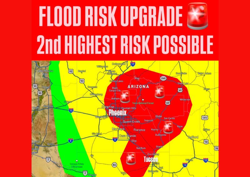
Forecast mapping shows the second highest flood risk category covering an extensive area stretching from north of Black Canyon City and Anthem through the entire Phoenix metropolitan area, including Surprise, Buckeye, Queen Creek, and Casa Grande, before continuing south to encompass Tucson and surrounding communities like Oro Valley and Vail. This corridor represents the zone where forecasters expect the most significant and repeated flooding impacts on Wednesday.
The highlighted risk area also extends eastward to include Globe, San Carlos, and portions of the Tonto National Forest, illustrating how this elevated flood threat spans a wide swath of central and southern Arizona rather than being confined to a single metropolitan area.
Several Instances of Flooding Expected
Forecasters were specific in warning that several instances of flooding are likely within this highlighted zone, language that suggests residents should anticipate more than just an isolated flooding concern in one location. This kind of repeated flooding potential often accompanies training thunderstorms, where multiple rounds of heavy rain move over similar areas, allowing runoff and flooding to compound throughout the day.
Given the scale of the area under this elevated risk, from the northern reaches near Black Canyon City down through Tucson, residents across a significant portion of the state should be prepared for the possibility of encountering flooded roadways or waterways at multiple points during Wednesday’s weather event.
Phoenix and Tucson Both Squarely Within the Highest Risk Zone
Both of Arizona’s two largest metropolitan areas, Phoenix and Tucson, fall directly within the zone of highest concern on Wednesday’s flood risk outlook. This positioning means the state’s most densely populated urban centers, along with their extensive network of roadways, washes, and low-water crossings, are squarely within the area forecasters expect to see the most significant flooding impacts.
The inclusion of both major cities within this elevated risk zone raises the potential for widespread impacts on daily activities, including possible road closures and travel disruptions, given how many residents and commuters move through the Phoenix and Tucson metro areas on a typical day.
Understanding the Flood Risk Categories
A second highest flood risk designation represents a significant escalation from more routine flood outlooks, typically reserved for situations where forecasters have high confidence that multiple locations within the highlighted zone will experience flooding severe enough to pose a genuine danger to life and property. This level of risk categorization is not issued lightly, reflecting a serious assessment of the atmospheric conditions expected to produce Wednesday’s rainfall.
Understanding where a specific location falls within these risk categories helps residents gauge the appropriate level of caution and preparation needed, with areas inside the red highest-risk zone warranting particular attention compared to the surrounding yellow zone, which still carries meaningful, though comparatively lower, flood potential.
Never Drive Into High Water
Officials reiterated one of the most critical flash flood safety messages ahead of Wednesday’s event: never drive into high water. This warning remains especially important given how quickly floodwaters can develop across Arizona’s characteristic washes and low-water crossings, where seemingly passable roadways can transform into dangerous, fast-moving hazards within minutes during intense desert thunderstorms.
This message carries particular urgency for residents throughout the highlighted flood risk zone, since the combination of urban drainage systems, natural washes, and the sheer number of roadways crossing flood-prone terrain across both Phoenix and Tucson creates numerous potential points where floodwater could threaten motorists who attempt to drive through standing water.
What Residents Should Do to Prepare
Residents across the highlighted flood risk zone, particularly within the Phoenix and Tucson metro areas, should plan for the possibility of flooded roadways and should identify alternate routes ahead of Wednesday in case primary travel paths become impassable. Given the elevated confidence reflected in this risk upgrade, residents should treat forecast flooding concerns for this event with particular seriousness rather than assuming typical monsoon-season caution will be sufficient.
For continuing coverage of severe weather events and critical storm analysis across the United States, visit svhsnow.com.