LITTLE ROCK, AR — A stubborn heat dome, high pressure system, or blob of heat, whatever forecasters want to call it, is in full force across Arkansas this week, continuing to promote well above average temperatures, dry weather, and generally unpleasant conditions statewide. The good news, according to forecasters, is that this blob of heat should finally break down by the end of the week and into early next week, offering genuine relief after an extended stretch of oppressive conditions.
The Blob of Heat Remains Firmly in Control
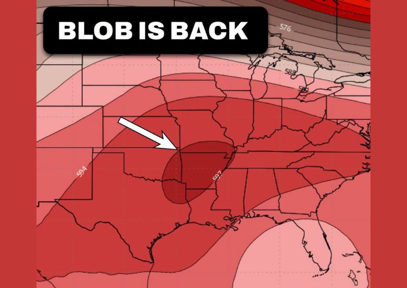
Upper-level pattern data shows an intense area of high pressure, colloquially referred to as the blob, centered directly over Arkansas and extending across much of the surrounding South Central United States. This pressure ridge, indicated by height values reaching 597 at its core, represents an unusually strong and well-established feature responsible for the extended stretch of hot, dry weather affecting the state.
The persistence of this high-pressure ridge is the primary driver behind this week’s continued well-above-average temperatures, as high pressure systems of this strength typically suppress cloud cover and precipitation while allowing temperatures to climb well beyond seasonal norms for an extended period.
Dry and Nasty Conditions Continue Statewide
Forecasters described the conditions accompanying this week’s heat dome in blunt terms, characterizing the overall pattern as dry weather combined with just nasty conditions across Arkansas. This combination of extreme heat and lack of precipitation represents a particularly uncomfortable stretch for residents, especially given how far into September this unusually intense summer-like pattern has persisted.
The dry conditions accompanying this heat dome also carry practical implications beyond simple discomfort, as extended periods without meaningful rainfall combined with high temperatures can contribute to increased fire risk and stress on vegetation and agricultural interests across the affected region.
Relief Finally Arrives at Week’s End
Despite the current intensity of this heat dome, forecasters offered genuine good news: the blob should finally break down by the end of this week and into early next week. This anticipated breakdown represents a meaningful shift in the broader atmospheric pattern, one that should bring an end to the extended stretch of well-above-average heat that has gripped Arkansas throughout the current period.
Forecasters were careful to temper expectations about what this breakdown will actually deliver, noting explicitly that residents should not expect pumpkin spice weather once the heat dome dissipates, but rather a more modest, though still meaningful, improvement compared to current conditions.
Highs Return to the 80s and Low 90s
Once the heat dome finally breaks down, forecasters project that afternoon highs across Arkansas should settle back into the 80s or low 90s, a range that, while still warm, represents a significant improvement compared to the more extreme temperatures currently associated with this week’s blob of heat. This shift would offer residents a meaningful, if not dramatic, reprieve from the most oppressive conditions of the current pattern.
That projected temperature range still reflects a warm early fall pattern typical for Arkansas this time of year, rather than a true cool-down, but represents a clear step in the right direction after an extended period of unusually intense heat.
A Second Blob Could Build Late This Month
Adding a note of caution to the otherwise positive outlook, forecasters flagged additional bad news: there are signs that another blob of heat could build again later this month. This potential redevelopment suggests the current relief, while welcome, may not represent a permanent transition away from the hot, high-pressure-dominated pattern that has characterized much of the recent weather across Arkansas.
Forecasters expressed cautious optimism regarding this potential second heat dome, suggesting it might not be as strong as the current system and hoping it would prove short-lived if it does develop, rather than settling in for an extended period similar to the current stretch.
Headed in the Right Direction
Despite the possibility of renewed heat later in the month, forecasters offered a broader reassurance to residents, stating a genuine belief that the overall pattern is headed in the right direction, even if it might not feel that way given current conditions. This perspective frames the current heat dome as a temporary, if stubborn, obstacle within a broader seasonal transition that remains generally on track toward eventual cooler weather.
That framing acknowledges the frustration many residents likely feel enduring an extended stretch of intense, out-of-season heat well into September, while still offering a measure of hope that the overall trajectory of the season continues moving toward more typical fall conditions, even with occasional setbacks along the way.
What Residents Should Expect
Residents across Arkansas should prepare for continued well-above-average temperatures, dry conditions, and generally uncomfortable weather through the remainder of this week as the current heat dome maintains its grip on the region. Relief should arrive by the end of the week and into early next week, bringing highs back into the 80s and low 90s, though residents should remain aware that another round of building heat remains possible later in the month.
For continuing coverage of severe weather events and critical storm analysis across the United States, visit svhsnow.com.