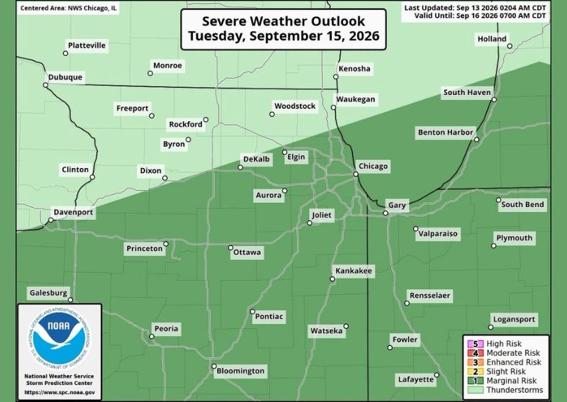
CHICAGO, IL — A marginal risk for severe thunderstorms is possible on Tuesday, September 15, particularly across areas south of Chicago, according to the latest Severe Weather Outlook. Meanwhile, thunderstorms are also expected Tuesday morning to the north of the city, though those storms are not expected to reach severe criteria, even as some communities in that area could see periods of heavy rainfall.
Marginal Risk Covers a Broad Area South of Chicago
The latest Severe Weather Outlook, valid through September 16, shows a marginal risk zone covering a substantial swath of territory extending south and west of Chicago, including communities such as DeKalb, Aurora, Joliet, Kankakee, and stretching as far south as Bloomington and Lafayette. This marginal risk category represents the lowest tier of organized severe weather risk, indicating the potential for isolated severe storms rather than a widespread or high-confidence severe weather event.
The outlook shows a clear dividing line running roughly through the northern Chicago suburbs, with the marginal risk zone covering everything from that boundary southward, while areas including Kenosha, Waukegan, and South Haven to the north fall outside the highlighted risk area entirely.
Morning Storms North of Chicago Expected to Stay Non-Severe
Ahead of the afternoon’s marginal severe risk farther south, thunderstorms are expected to develop Tuesday morning across areas north of Chicago, though forecasters were clear these storms are not expected to become severe. This morning activity appears to be part of a broader weather system that will play a role in shaping the afternoon’s severe weather potential farther south.
Forecast surface-based CAPE data, a measure of atmospheric instability, valid for 22z Tuesday, shows an area of energy building across portions of Illinois, Indiana, and Michigan, with values reaching into the thousands of joules per kilogram in some areas, indicating a moderately unstable atmosphere capable of supporting thunderstorm development across the region.
Morning Activity Expected to Push a Front South
Forecasters indicated that the morning thunderstorm activity north of Chicago will likely push a front southward through the region during the Tuesday afternoon hours. This frontal movement is expected to play a key role in determining where the best atmospheric instability, and therefore the greatest severe weather potential, ultimately sets up later in the day.
This dynamic, where morning convection helps reposition a front and effectively relocates the most favorable severe weather ingredients, adds a layer of complexity to Tuesday’s forecast, since the exact placement of that front by the afternoon will significantly influence which areas see the greatest severe thunderstorm potential.
Best Instability Expected to Shift Well South
Forecasters specifically noted that this morning activity will likely send the best instability well south of the immediate Chicago area by the time the afternoon severe weather threat develops. This anticipated southward shift is a key reason the marginal risk zone extends so far south of the city itself, encompassing areas as distant as central Illinois and northern Indiana.
Given this expected displacement of instability, communities farther south, including those near Peoria, Bloomington, and Lafayette, may end up seeing more favorable conditions for severe thunderstorm development on Tuesday afternoon compared to areas closer to Chicago itself.
Forecaster Expresses Some Uncertainty About the Setup
In a notably candid assessment, the forecaster indicated they are not feeling particularly confident about this severe weather setup, reflecting genuine uncertainty about exactly how Tuesday’s atmospheric dynamics will play out. This kind of transparency about forecast confidence is a useful signal for residents, suggesting the marginal risk designation itself already reflects a fairly cautious, lower-confidence severe weather outlook.
That uncertainty extends to the heavy rain potential as well, with forecasters indicating they hope to nail down more specific details soon about exactly where the heaviest rainfall will fall on Tuesday morning, particularly across the area north of Chicago.
Heavy Rain Remains a Concern North of Chicago
Despite the non-severe classification for Tuesday morning’s storms north of Chicago, forecasters cautioned that some areas will see heavy rain during that timeframe, with the heaviest totals particularly likely closer to the city itself. This heavy rain potential represents a separate concern from the severe thunderstorm risk farther south, focused instead on potential flooding or drainage issues from intense morning rainfall.
Communities across the northern Chicago suburbs and the city itself should be prepared for the possibility of locally heavy downpours during the Tuesday morning hours, even though the associated thunderstorms are not expected to produce the kind of damaging wind or hail associated with severe weather.
What Residents Should Expect
Residents across northern Illinois, particularly Chicago and its northern suburbs, should prepare for potentially heavy rain during Tuesday morning, while those farther south, from the southern Chicago suburbs through central Illinois and into northern Indiana, should monitor conditions for the marginal severe thunderstorm risk expected to develop Tuesday afternoon. Given the forecaster’s noted uncertainty about this setup, continued monitoring of updated forecasts will be important as Tuesday approaches.
For continuing coverage of severe weather events and critical storm analysis across the United States, visit svhsnow.com.