TALLAHASSEE, FL — A small shot of lower humidity will make its way through most of Florida this week, especially from Wednesday through Friday, with dew points, a measure of humidity, potentially dropping as low as the 50s across the Panhandle. Forecasters say morning temperatures could also dip into the 60s during this brief window, though they cautioned residents to keep expectations low, since this represents only a slight bit of relief rather than a major cool-down.
Panhandle Sees the Most Noticeable Improvement
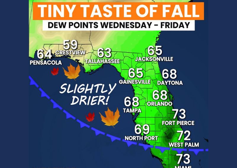
Forecast dew point data for Wednesday through Friday shows the Panhandle region experiencing the most significant drop in humidity, with Crestview projected at just 59 degrees and Pensacola and Tallahassee following close behind at 64 and 63 degrees respectively. These readings represent some of the driest, most comfortable air expected anywhere in the state during this stretch.
This concentration of the lowest dew points in the western Panhandle reflects that region’s typical pattern of being first to benefit from drier air masses moving in from the north, a common feature of early fall pattern shifts before drier conditions eventually push farther south and east across the peninsula.
North and Central Florida See Modest Improvement
Moving eastward and into North Florida, dew points remain slightly higher but still improved compared to typical late-summer humidity levels, with Jacksonville projected at 65 degrees and Gainesville also at 65 degrees. These readings suggest a more modest, though still noticeable, improvement in comfort levels compared to the more dramatic drop expected across the western Panhandle.
Central Florida communities including Tampa, Orlando, and Daytona are forecast to see dew points generally in the 68 degree range, reflecting a smaller but still perceptible reduction in humidity compared to what residents in that part of the state have likely experienced through much of the summer.
South Florida Sees the Smallest Change
As is typical with fronts and drier air pushing into Florida, the effects diminish considerably by the time they reach the southern portion of the state, with North Port forecast at 69 degrees, West Palm Beach at 72 degrees, Fort Pierce at 73 degrees, and Miami also projected near 73 degrees. These readings remain firmly in the muggy, tropical range typical of South Florida, even during this week’s broader statewide push toward drier air.
This geographic gradient, growing progressively less pronounced from north to south, illustrates the common pattern where drier continental air masses moving into Florida gradually lose their punch as they travel farther into the peninsula, leaving South Florida largely unaffected by improvements felt farther north.
Keeping Expectations Realistic
Forecasters were direct in cautioning residents to keep their expectations low regarding this particular shift, describing it explicitly as a small shot of relief rather than a significant or lasting change to the state’s overall humid summer pattern. This messaging helps set realistic expectations, particularly for anyone hoping for a more dramatic or extended break from Florida’s typical late-summer mugginess.
Despite the modest scale of this improvement, forecasters characterized it as still worthwhile, offering at least a little bit of relief and a hint that fall conditions are edging closer, even if the full transition remains further off for most of the state.
A Hint of Fall Around the Corner
While this week’s dew point drop is not expected to bring dramatic or lasting change, forecasters framed it as a genuine, if small, hint that fall is approaching for Florida. This kind of brief, limited improvement is often one of the earliest signals of the gradual seasonal transition that eventually brings more substantial and longer-lasting relief from summer humidity later in the year.
For a state where meaningful fall weather often arrives later and more gradually than in much of the rest of the country, even a modest, short-lived drop in humidity like this week’s forecast can serve as a welcome and encouraging sign of changing seasons for residents eager to move beyond the peak of summer’s mugginess.
What Residents Should Expect
Residents across Florida, particularly in the Panhandle and North Florida, should notice a modest but real improvement in humidity levels from Wednesday through Friday, with morning temperatures potentially dipping into the 60s in some areas. Those in Central and South Florida should expect a smaller, less noticeable change, with South Florida in particular likely to remain firmly in its typical muggy, tropical conditions throughout the week.
For continuing coverage of severe weather events and critical storm analysis across the United States, visit svhsnow.com.