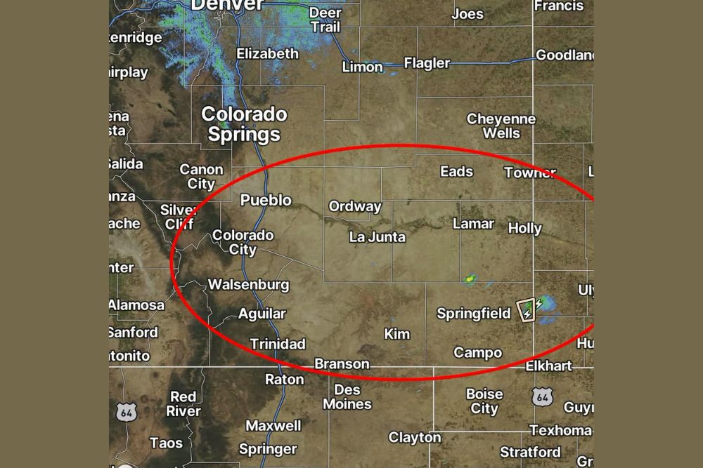
PUEBLO, CO — Forecasters are warning that a few strong to severe storms could develop overnight tonight across southern and southeastern Colorado, with the primary threat area concentrated within a broad zone stretching from near Pueblo and Canon City eastward through La Junta and Lamar, and southward toward Trinidad and Springfield. Radar already shows scattered storm activity developing near the Springfield area, offering an early indication of the kind of convection expected to expand across the highlighted zone as the overnight hours progress.
Highlighted Threat Zone Spans Southeastern Colorado
The area of greatest concern for tonight’s storms stretches in a wide band from Canon City and Pueblo in the west, across Ordway and La Junta in the central portion of the zone, and extending to Lamar, Holly, and Springfield near the state’s eastern edge. This broad coverage area also dips south to include Walsenburg, Aguilar, and Trinidad, capturing a significant portion of southern and southeastern Colorado within the highlighted risk zone.
Communities positioned along this corridor should be aware that any storms developing within the outlined area carry the potential to reach strong or severe criteria, meaning residents in these locations should remain weather-aware through the overnight hours as the threat evolves.
Storms Already Developing Near Springfield
Current radar data shows an area of thunderstorm activity already forming near Springfield, in the far southeastern portion of the highlighted zone, offering a preview of the kind of convection expected to develop more broadly across the region as the night progresses. This initial activity suggests the atmosphere is already primed for storm development ahead of the overnight period when the greatest concentration of strong to severe storms is anticipated.
The presence of this early activity near the eastern edge of the outlined zone indicates that conditions are already becoming favorable for thunderstorm development, a trend that forecasters expect to continue and potentially expand westward across the broader highlighted area as overnight hours arrive.
What Strong to Severe Storms Could Bring
Storms that reach strong or severe intensity within this region during the overnight hours typically carry the potential for hazards including gusty or damaging winds, small to occasionally larger hail, and frequent lightning. Given the timing of this threat overnight, residents should be particularly mindful of the possibility of storms developing or intensifying while many people may be asleep, making advance weather awareness especially important.
The nighttime timing of this threat also means visibility and warning time could be more limited for anyone caught outdoors or traveling through the affected region compared to a daytime severe weather event, adding an extra layer of caution for residents in the highlighted zone.
Broader Regional Context
Southeastern Colorado is no stranger to overnight thunderstorm activity during the late summer months, particularly as monsoonal moisture and daytime heating from the Rocky Mountain foothills interact with the flatter terrain of the eastern plains to produce nocturnal convection. Tonight’s setup appears consistent with that seasonal pattern, with the greatest risk concentrated across the southern and southeastern portions of the state rather than the more urbanized Front Range corridor near Denver and Colorado Springs.
The broader region surrounding tonight’s highlighted zone, including areas of eastern Colorado near Cheyenne Wells and Eads, could also see spillover effects from the developing storms, even if the most concentrated risk remains within the specifically outlined area.
What Residents in the Threat Zone Should Do
Residents across the highlighted portion of southern and southeastern Colorado, including communities like Pueblo, La Junta, Trinidad, and Springfield, are encouraged to remain aware of changing conditions overnight and to have a way to receive weather alerts even while sleeping, given the nighttime timing of this potential severe weather threat. While not every storm within the outlined zone is expected to reach severe criteria, the overall setup supports the potential for a few storms to become strong or severe as the night progresses.
Continued monitoring of radar trends, particularly as the activity currently near Springfield evolves, will help clarify how the overnight threat develops across the remainder of the highlighted region through the early morning hours.
For continuing coverage of severe weather events and critical storm analysis across the United States, visit svhsnow.com.