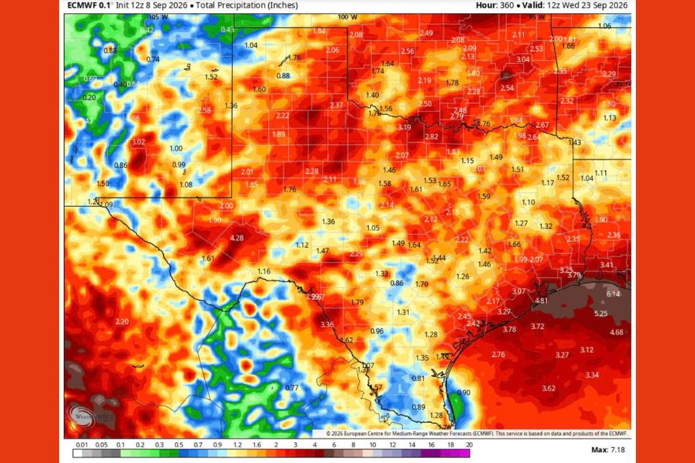
AUSTIN, TX — After enduring an unusually dry stretch, Texas is finally looking at a real shift in its weather pattern, with forecast model data pointing toward widespread, significant rainfall arriving by the 20th of September. A ECMWF forecast model valid through September 23 shows little change across the state over the next ten days, but highlights a strong cool front expected to move through around that timeframe, delivering what forecasters describe as the best rainfall totals the state has seen in months.
Little Change Expected Before the Real Pattern Shift
Forecasters emphasized that conditions across Texas will remain largely unchanged for roughly the next ten days, meaning the current dry and warm pattern will persist before any meaningful rainfall arrives. That extended period of stability makes the shift projected around the 20th of September stand out even more, since it represents a clear break from weeks of limited precipitation across much of the state.
The forecast model data shows total precipitation projections building dramatically by the valid time of 12z on September 23, with widespread totals exceeding an inch across huge stretches of Texas, a stark contrast to the drier conditions that have dominated the state’s recent weather.
Heaviest Totals Concentrated Along the Gulf Coast
The forecast model highlights the Gulf Coast and southeastern Texas as the areas likely to see the most dramatic rainfall totals once the front and associated moisture move through. Model data shows totals reaching as high as 6 to 7 inches in isolated pockets near the coast, with widespread 3 to 5 inch totals extending across much of the southeastern quarter of the state.
Farther inland, including the Dallas-Fort Worth and Austin areas, projected totals remain substantial as well, generally falling in the 1.5 to 2.5 inch range, still a meaningful improvement for areas that have seen limited rainfall in recent weeks. Even portions of the Texas Panhandle and West Texas, historically drier regions, show projected totals exceeding an inch in the forecast data.
A Strong Cool Front Drives the Change
The mechanism behind the shift is a strong cool front forecast to push through Texas around the 20th of September, a system expected to interact with available Gulf moisture to produce the widespread rainfall shown in the extended model data. Cool fronts moving through the state in early autumn often serve as the trigger for the state’s first significant rain events following the peak of summer heat, and this system appears positioned to do exactly that.
Forecasters noted that while confidence in the exact timing and placement of rainfall this far out remains limited, the overall signal for a substantial rain event has been consistent enough across model runs to generate real optimism for a state that has been waiting for meaningful relief.
El Nino Continues to Strengthen in the Pacific
Adding context to the broader pattern, El Nino conditions in the tropical Pacific have continued to strengthen through the summer, with sea surface temperature anomalies in the Nino 3.4 region climbing significantly in recent months. Climate forecasters have described the ongoing event as increasingly likely to become one of the stronger El Nino events on record, with a greater than 90 percent chance of reaching very strong intensity heading into the fall and winter.
A strengthening El Nino often influences storm tracks and moisture patterns across Texas and the broader Southern Plains during the fall and winter months, typically favoring a wetter pattern compared to years without an active El Nino signal, which may help explain the improved rainfall outlook building into the back half of September.
What Comes Next for Texas
With roughly ten quiet days expected before the front’s arrival, residents across Texas have a window to prepare for what forecasters are calling the best rain chances the state has seen in months. The scale of the projected totals, particularly along the Gulf Coast, suggests this could be a significant rainfall event rather than a marginal or scattered one.
Continued monitoring of the forecast will be essential as the 20th of September approaches, since extended-range model data can still shift in both timing and total amounts as the event draws closer.
For continuing coverage of severe weather events and critical storm analysis across the United States, visit svhsnow.com.