ATLANTA, GA — A near-record strong El Niño developing in the Pacific could make the upcoming winter particularly interesting for snow lovers across the country, according to early seasonal model data being closely monitored by meteorologists, with forecasters emphasizing that while the outlook remains preliminary, it offers an early glimpse of how the season’s storm tracks and snowfall patterns might unfold.
Two Seasonal Models Point to a Similar Story
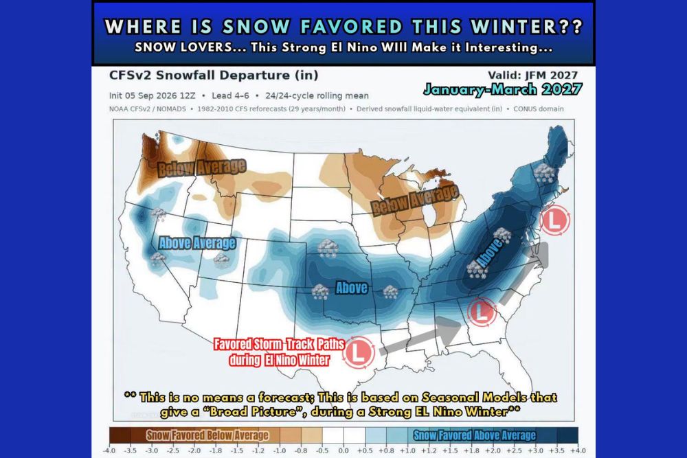
Meteorologists tracking the developing pattern have been monitoring two primary seasonal forecasting tools over the past several months, the CFSv2 model and the CanSIPS model, both of which are designed to provide broad, long-range guidance on how an upcoming season might trend based on current oceanic and atmospheric conditions. A snowfall departure map generated from the CFSv2 model, valid for January through March 2027, shows a striking pattern of above-average snowfall favored across a wide swath of the central and eastern United States, while below-average snowfall is favored across parts of the Pacific Northwest and the Upper Midwest.
Where Snow Is Currently Favored
According to the CFSv2 model output, areas favored to see above-average snowfall this winter include a broad corridor stretching from the central Plains through the Ohio Valley and into the Northeast, with the deepest blue shading, indicating the strongest above-average signal, concentrated across parts of the Appalachians and reaching up into New England. Two areas of favored low-pressure storm track development are highlighted on the map, one positioned over the Gulf Coast region and another over the Northeast, both consistent with the kind of storm track commonly associated with El Niño winters.
Conversely, areas shaded in brown, indicating a favored below-average snowfall signal, include portions of the Pacific Northwest, the Northern Rockies, and a stretch of the Upper Midwest and Great Lakes region, suggesting these areas could see a quieter, less snowy winter compared to typical seasonal norms if the current model signal holds.
Why El Niño Matters for Winter Storm Tracks
El Niño winters are historically associated with a fairly well-documented shift in the position of the jet stream, which tends to push the storm track farther south across the United States compared to a typical or La Niña winter. This southward-displaced storm track often brings increased precipitation, and in colder areas, increased snowfall, across the southern and eastern United States, while leaving the Pacific Northwest and northern tier of states comparatively drier than average.
With this El Niño event being tracked as potentially near-record in strength, the typical El Niño impacts on storm track positioning could be even more pronounced than in a weaker or moderate event, though meteorologists caution that stronger El Niño events do not always translate into simply amplified versions of typical impacts, since each event carries its own unique characteristics.
An Early Look, Not a Locked-In Forecast
Meteorologists were notably careful to frame this outlook as a very early idea of what could happen based on current data, explicitly cautioning that this is not a hard-set forecast and should not be taken at face value. Seasonal models of this nature are known to shift considerably as the actual winter season approaches, and forecasters emphasized this data is being shared for informational and discussion purposes rather than as a definitive prediction residents should plan around.
This kind of measured, early-season framing is standard practice among meteorologists when discussing seasonal outlooks derived from models like CFSv2 and CanSIPS, both of which are useful for identifying broad patterns and trends but carry considerably more uncertainty than shorter-range forecasts covering days or even weeks rather than months.
What Residents Should Take Away
Forecasters were explicit that this early look at potential winter patterns is intended for general interest and discussion rather than as guidance on specific preparations, cautioning that it is in no way meant to suggest how much winter gear, or how much bread and milk, residents need to stock up on based on this early data. As with any seasonal outlook this far in advance, the specific details are expected to become clearer and more reliable as the winter season draws closer.
Looking Ahead to Winter 2026-2027
Meteorologists will continue monitoring both the CFSv2 and CanSIPS models throughout the fall as additional data becomes available, watching to see whether the current signal favoring above-average snowfall across the central and eastern United States strengthens, weakens, or shifts as the near-record El Niño continues to develop heading into the winter season.
For continuing coverage of severe weather events and critical storm analysis across the United States, visit svhsnow.com.