BIRMINGHAM, AL — Alabama faced another round of dangerous heat and the potential for strong storms Saturday, following a Friday that saw Birmingham reach 100 degrees and Tuscaloosa hit 101 degrees, with temperatures forecast to climb quickly through the morning into the upper 90s and near 100 degrees again by afternoon, pushing heat index values as high as 105 degrees.
Another Scorching Day Across the State
Saturday’s high temperature outlook shows Birmingham reaching 98 degrees, well above the seasonal average of 89 degrees for this time of year, with the extended forecast showing little relief through the coming week as highs remain locked in the 92 to 94-degree range from Sunday through Friday. That sustained stretch of well-above-average heat reflects a persistent pattern that has gripped the state for multiple consecutive days, with Saturday marking the peak of the current heat surge before a gradual, modest cooling trend begins to take hold.
Sweltering Conditions Await Tuscaloosa Football Fans
Anyone heading to the Alabama football game in Tuscaloosa Saturday was urged to prepare for sweltering conditions, with temperatures inside Bryant-Denny Stadium expected to reach the mid to upper 90s around kickoff, and considerably hotter readings likely in areas exposed to direct sunshine. While conditions were expected to remain mostly dry around game time, fans were strongly encouraged to stay hydrated and take full advantage of the cooling and water stations positioned throughout the stadium given the extreme heat.
Storm Chances Build Through the Afternoon
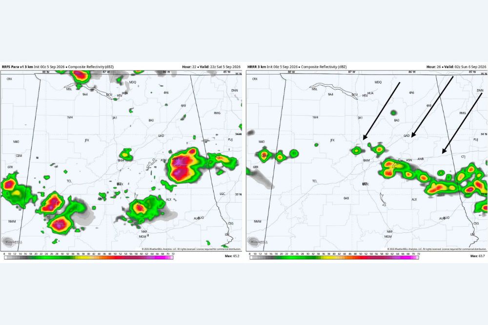
Beyond the heat itself, forecasters were tracking an increasing chance for storms as Saturday progressed. A few showers were possible across southern Alabama during the morning hours, but as temperatures continued to soar into the afternoon, scattered pop-up storms were expected to become increasingly likely. Meteorologists were also watching a line of storms developing across eastern Tennessee that could eventually work its way south into Alabama, with the better opportunity for storm development expected generally east of Interstate 65 later in the afternoon and evening.
Given the extremely hot and unstable atmospheric environment in place, any storms that do manage to develop carry the potential to produce gusty winds, frequent lightning, and very heavy rainfall. Radar imagery showed scattered strong cells already beginning to fire across the region, with several intense cores visible tracking through the eastern and southeastern portions of the state.
Labor Day Weekend Stays Hot
Looking ahead to Sunday and the remainder of the Labor Day weekend, forecasters indicated the heat is not going anywhere, with highs generally expected in the mid 90s. Saturday’s storm coverage could have some influence on exactly how hot Sunday ends up, but another round of scattered afternoon showers and storms remains possible as the unstable pattern persists into the holiday itself.
Gradual Relief Arrives Next Week
Some easing of the pattern is expected as the new week begins, with rain chances decreasing and temperatures backing off slightly through the middle of the week. Even with that modest improvement, Alabama residents should not expect a dramatic change, as forecasters noted plenty of 90-degree afternoons and continued sunshine are likely to persist even as the most extreme heat moderates somewhat.
Farther out, meteorologists are watching a potential frontal boundary that could approach Central Alabama by Thursday or Friday, which could bring another opportunity for storms later in the week. Forecasters cautioned that this remains a longer-range possibility with considerable time for the forecast to change before then.
Staying Safe Through the Holiday Weekend
With dangerous heat and the potential for strong to severe storms both in play, residents across Alabama are urged to take precautions on multiple fronts, staying hydrated and limiting prolonged outdoor exposure during peak afternoon heat while also remaining alert for rapidly developing storms capable of producing gusty winds and heavy rain as the unstable pattern continues.
For continuing coverage of severe weather events and critical storm analysis across the United States, visit svhsnow.com.