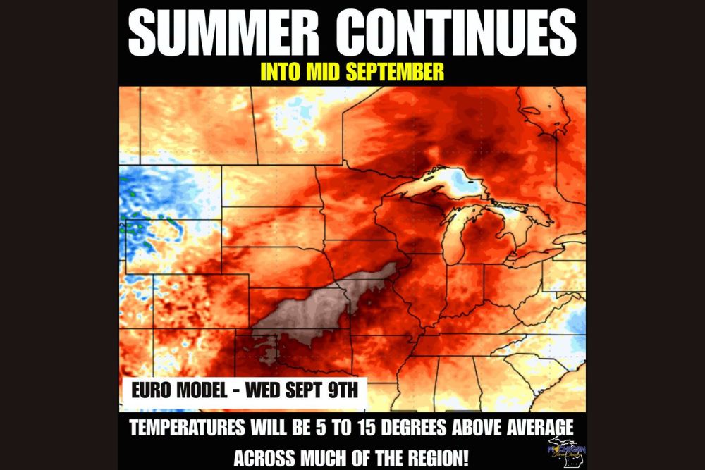
DETROIT, MI — Fall remains firmly on pause across much of the Midwest as warmer than average temperatures are set to dominate the weather pattern into mid-September, with the Euro model projecting readings running 5 to 15 degrees above average across a broad swath of the region stretching from Michigan through the Ohio Valley and into parts of the Southeast.
A Persistent Warm Signal Takes Hold
Long-range model guidance from the European weather model, valid for Wednesday, September 9th, paints a striking picture of widespread warmth dominating the central and eastern United States. The map shows deep red and orange shading, representing the most significant temperature departures from normal, blanketing nearly the entire Great Lakes region, including Michigan, Wisconsin, Illinois, Indiana, and Ohio, along with extending south into Kentucky, Tennessee, and portions of the Carolinas.
The intensity of the shading across this stretch indicates that many locations within this footprint could see temperatures running toward the higher end of that 5-to-15-degree departure range, reflecting a robust and well-established warm pattern rather than a marginal or borderline warm signal. Only isolated pockets across the Pacific Northwest and interior West, shown in blue on the model output, are expected to see near or below normal temperatures during this same period.
Temperatures in the 70s and 80s Expected to Persist
With this pattern locked in, forecasters indicated that temperatures across the affected region should continue running in the 70s and 80s through the period, well above what is typically expected as the calendar moves deeper into September. For a time of year when many communities across the Midwest and Great Lakes normally begin seeing more noticeable early signs of the transition toward fall, this extended stretch of summer-like warmth represents a meaningful departure from the seasonal norm.
The persistence of this pattern through at least the middle of the month suggests the region’s typical early autumn cooldown is being delayed rather than simply arriving a few days later than average, a distinction that matters for anyone hoping to see meaningful relief from the summer-like conditions that have already dominated much of the season.
Off and On Severe Weather Chances Remain
Alongside the continued warmth, forecasters also flagged the potential for off and on severe weather chances to accompany the pattern as it persists into mid-September. Warm, humid air masses lingering later into the season than typical can continue to provide the fuel needed for periodic rounds of thunderstorms, some of which may reach severe criteria given the amount of instability such an extended warm pattern can support.
This combination of sustained warmth and intermittent severe weather potential mirrors a pattern that has already produced numerous rounds of storms, flooding, and heat-related impacts across the broader region in recent weeks, suggesting communities should not expect a complete return to calm, stable weather even as any individual days may bring sunshine and comfortable-seeming conditions.
Why the Warm Pattern Has Proven So Persistent
Extended warm patterns like this one are often tied to a broader atmospheric configuration that resists typical seasonal transitions, allowing warmer air masses to remain anchored over a region for extended stretches rather than giving way to the more typical early fall pattern of alternating warm and cool air masses. When this kind of setup becomes entrenched, it can take a significant shift in the broader atmospheric pattern, rather than just the passage of a single cold front, to finally break the cycle and usher in more seasonable conditions.
What Residents Should Expect Going Forward
With the warm pattern expected to persist through at least the middle of September, residents across the Midwest and Great Lakes region should plan for continued above-average temperatures and the possibility of scattered severe weather rather than anticipating an imminent return to more typical early autumn conditions. Those hoping for the first real taste of fall weather may need to wait considerably longer than usual this year given how firmly this warm pattern appears to be entrenched.
Meteorologists will continue monitoring the extended model guidance for any signs of the pattern finally beginning to break down, though current indications suggest little change through at least the first half of the month.
For continuing coverage of severe weather events and critical storm analysis across the United States, visit svhsnow.com.