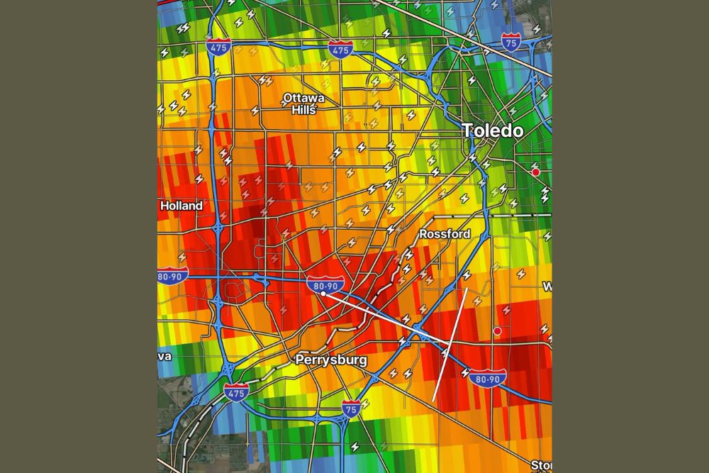
TOLEDO, OH — An extreme overnight lightning storm bombarded the Toledo, Ohio region early Friday, with an astonishing 2,000 lightning strikes recorded within 25 miles of the city in just the past hour alone, a rate equivalent to a lightning flash occurring roughly every 2 seconds as the storm rolled through the area.
An Extraordinary Rate of Lightning Activity
The lightning detection data, updated at 5:38 AM, showed an intense concentration of strikes blanketing communities including Sylvania, Ottawa Hills, Holland, Rossford, and Perrysburg, with the heaviest lightning density appearing to track along the Interstate 80/90 corridor and the areas immediately surrounding downtown Toledo. Radar imagery accompanying the lightning data showed a broad, intense area of storms with embedded heavier cores, consistent with the kind of electrically active thunderstorm complex capable of producing such an extraordinarily high strike rate.
What Makes This Storm So Electrically Active
A rate of roughly one lightning flash every two seconds within a 25-mile radius represents an exceptionally intense level of electrical activity, far beyond what a typical thunderstorm produces even during its most active phase. This kind of extreme lightning frequency is generally associated with strong updrafts within a storm, which allow ice crystals and graupel, a soft hail-like precipitation, to collide at a rapid pace high in the storm, building up the electrical charge separation that ultimately produces lightning.
Storms capable of sustaining this level of lightning output over an extended period, rather than just a brief burst, often indicate a well-organized and vigorously developing system, one with enough instability and moisture to keep the lightning-producing mechanism working continuously as the storm moves through an area. The overnight and early morning timing of this event also meant the storm’s lightning was likely highly visible to residents across the Toledo metro area, illuminating the sky repeatedly as the system tracked through the region.
Communities in the Path of the Storm
The area experiencing the heaviest lightning activity spanned a wide swath of the Toledo metro region, stretching from Sylvania in the north down through Ottawa Hills, central Toledo, and continuing south toward Rossford and Perrysburg along the I-75 and I-80/90 corridors. Radar data indicated the most intense storm cores, shown in deep red and orange shading, were positioned directly over the Ottawa Hills and Perrysburg areas at the time of the update, suggesting those communities may have experienced the highest concentration of strikes during the height of the storm’s passage.
Given the extensive highway network running through the affected area, including the heavily traveled I-75, I-475, and I-80/90 corridors, the early morning timing of this storm carried particular significance for overnight and early commuter traffic, with frequent lightning posing a hazard for anyone outdoors or pulled over along the roadway during the height of the activity.
The Dangers of Extreme Lightning Events
Storms producing lightning at this frequency carry an elevated risk profile even when other severe weather hazards like damaging wind or hail remain limited. Lightning is one of the most consistent weather-related killers in the United States each year, and a storm capable of producing a strike roughly every two seconds across a 25-mile radius significantly increases the statistical likelihood of a strike occurring in populated areas, striking structures, or affecting outdoor infrastructure during the event.
Safety officials routinely emphasize that there is no truly safe place outdoors during an active lightning storm, and that the standard guidance, seeking shelter in a sturdy building or hard-topped vehicle and remaining there until well after the last rumble of thunder, becomes especially critical during storms producing this level of continuous electrical activity.
Looking Ahead for the Toledo Region
As the storm continues tracking through the region, meteorologists will be watching for any signs of the lightning activity beginning to taper as the system moves east, while also monitoring for any additional hazards, including heavy rainfall rates, that frequently accompany storms of this intensity and electrical output.
Residents across the Toledo metro area are advised to remain weather-aware through the early morning hours, avoid unnecessary outdoor activity while the storm remains active nearby, and treat the unusually high lightning frequency as an indicator of a particularly vigorous and potentially hazardous storm system moving through the region.
For continuing coverage of severe weather events and critical storm analysis across the United States, visit svhsnow.com.