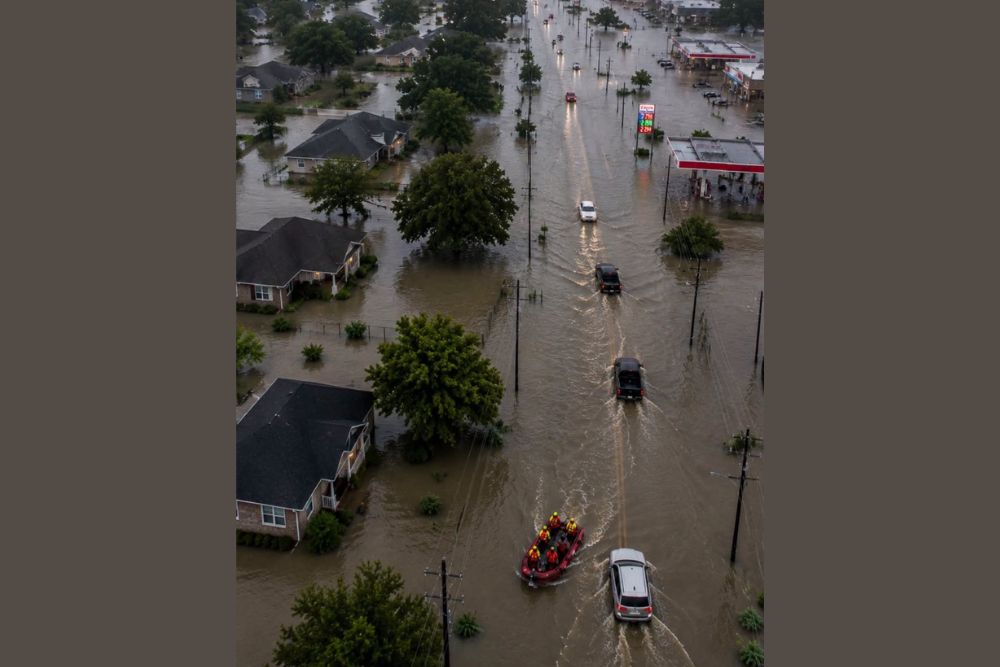
KOUNTZE, TX — Catastrophic flooding continued to overtake Southeast Texas on Wednesday into Thursday after remnant moisture from Tropical Storm Edouard dumped as much as 21 inches of rain across Hardin and Tyler Counties, triggering dozens of water rescues and forcing the evacuation of an assisted-living facility as floodwaters pushed into homes and roadways throughout the region.
Rescues Multiply Across the Region
Emergency crews spent Wednesday pulling stranded motorists from flooded roads and rescuing residents trapped inside homes as water levels rose rapidly across the hardest-hit counties. Among the most urgent operations was the evacuation of 21 residents from an assisted-living facility as rising water moved into the building, requiring responders to relocate individuals unable to walk on their own to safety before conditions worsened further.
Torrential Rainfall Totals Shatter Expectations
The rainfall totals driving this event have been staggering even by flash-flood standards. Parts of Hardin and Tyler Counties recorded between 10 and 21 inches of rain, with rainfall rates at times reaching as high as 5 inches per hour, according to the National Weather Service. That kind of intensity overwhelms drainage systems and creek beds almost immediately, turning normally passable roads into fast-moving hazards within a matter of minutes rather than hours.
Communities including Kountze, Village Mills, Honey Island, Saratoga, Warren, and Batson bore the brunt of the heaviest bands, with a flash flood emergency, the highest level of flood warning issued by the National Weather Service, activated across the region as water continued to rise through the overnight hours. Officials repeatedly urged residents to seek higher ground immediately rather than attempt to wait out the flooding or evacuate by vehicle once water began entering their neighborhoods.
Village Creek Threatens Major Flood Stage
With the immediate rescue operations underway, attention has now shifted downstream to Village Creek near Kountze, which is expected to climb to approximately 23.3 feet by early Thursday morning, a level that would place it firmly into major flood stage. Major flooding at that stage typically means significant inundation of low-lying roads, agricultural land, and structures situated near the creek, with the surge of water still working its way through the watershed even as rainfall itself begins to taper off in some areas.
The delayed nature of this secondary threat is part of what makes Southeast Texas flooding events so dangerous. Even after the heaviest rain bands move on, the sheer volume of water collected across the watershed continues draining into creeks and rivers, causing levels to keep rising for hours or even a full day after the rain has stopped, catching residents off guard if they assume the danger has passed once the skies clear.
A Broader Pattern of Compounding Impacts
Beyond the immediate flooding, the storm’s remnants have left a trail of secondary damage across the region, including downed trees and widespread power outages tied to gusty winds that accompanied the heaviest rain bands. Local officials in multiple counties have activated emergency operations and issued disaster declarations to unlock additional resources for response and recovery efforts as the situation continues to evolve.
Water rescue teams, including state game wardens and local first responders, remain positioned throughout the affected counties as the threat continues, with officials cautioning that additional rescues are likely as long as heavy rain and rising creek levels persist across Southeast Texas. Residents are being asked to avoid unnecessary travel entirely rather than attempt to judge the depth of water covering a roadway, since floodwater can conceal washed-out pavement or swiftly moving currents that are not visible from a vehicle.
Why This Event Has Been So Severe
Meteorologists point to the combination of a slow-moving tropical system and an unusually moisture-rich atmosphere as the key drivers behind the extreme rainfall totals. When a system stalls or moves sluggishly inland, as occurred with this system’s remnants, it allows repeated rounds of heavy rain to fall over the same communities for an extended period, a phenomenon known as training, which is precisely what pushed rainfall totals in some spots close to two feet.
This pattern has proven especially dangerous for low-lying communities along creeks and waterways, where even modest additional rainfall on top of already saturated ground can push water levels into major flood stage rapidly. Emergency managers across the affected counties have emphasized that the flooding threat remains active and evolving, urging residents not to let their guard down simply because the heaviest rain has moved through their immediate area.
What Comes Next for Southeast Texas
As Village Creek and other waterways across the region approach their crest, officials are continuing to monitor river gauges closely for any signs of additional rises that could threaten homes and infrastructure not yet impacted by the initial flooding. Recovery efforts in the hardest-hit communities are expected to begin in earnest once water levels recede enough for damage assessments to safely proceed.
For now, the message from emergency officials across Southeast Texas remains consistent: floodwaters are still moving through the region, creek levels remain dangerously high, and residents in flood-prone areas should continue treating the situation as an active and ongoing emergency rather than one that has already passed.
For continuing coverage of severe weather events and critical storm analysis across the United States, visit svhsnow.com.