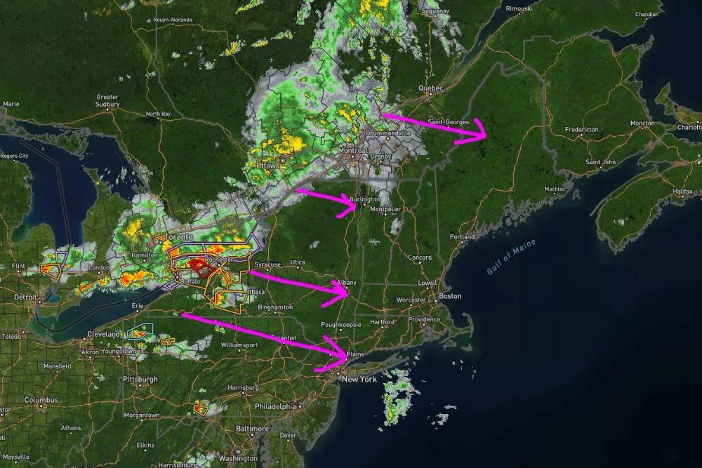
ALBANY, NY — An active night of weather is unfolding across New England as a large Mesoscale Convective System, or MCS, tracks eastward out of New York and pushes into Vermont, Massachusetts, New Hampshire, Connecticut, and Rhode Island through the overnight hours. Radar imagery shows a broad cluster of organized thunderstorms stretching from the Great Lakes region through the Ottawa and Montreal corridor and sliding southeast toward Albany, Burlington, and the New York state line, with additional development expected to spread across the rest of the region as the night progresses.
What an MCS Actually Is
An MCS, short for Mesoscale Convective System, is a large, organized cluster of thunderstorms that begins working together as one bigger weather system rather than acting as isolated cells. Instead of a single storm popping up over one town, an MCS represents dozens of thunderstorms essentially banding together, capable of covering a wide area and producing very heavy rainfall, frequent lightning, strong wind gusts, and occasionally hail. Importantly, an MCS moving through a region does not mean everyone in its path will see severe weather, but it does raise the likelihood of locally intense downpours and gusty winds along its track.
Timing for Western New England
The more organized thunderstorm activity is expected to approach eastern New York and western portions of Massachusetts and Vermont late this evening, with the primary window running roughly from 11 PM through 4 AM. The greatest concern for stronger storms remains closer to New York, though some of that stronger activity could survive as it pushes into western New England.
Heavy rain may end up being the bigger overall concern in this zone. Some storms embedded within the MCS could produce rainfall rates of 1 to 2 inches per hour, particularly in spots where thunderstorms repeatedly track over the same locations, a setup that can quickly lead to localized flooding on roads and in low-lying areas even without severe thunderstorm warnings being issued.
Vermont, New Hampshire, and Maine Timing
Rain becomes more widespread across Vermont this evening and overnight, with embedded thunderstorms possible. Severe weather is generally not expected across most of the state, although locally heavy rainfall and gusty winds remain possible as the system moves through.
Farther north and east, rain begins reaching northern New Hampshire and Maine around sunset before spreading south and east through the evening hours. Thunderstorms are possible during this window, particularly across western New Hampshire, before the activity transitions into steadier overnight rain with embedded heavier downpours as the night wears on.
Southern New England Joins the Round Later
Massachusetts, Connecticut, and Rhode Island are expected to get into the main round of activity later in the overnight period. Showers should begin reaching western Massachusetts and Connecticut around 2 AM, then spread toward eastern Massachusetts and the coastline roughly between 4 and 6 AM.
Heavy downpours and embedded thunderstorms remain possible across southern New England, but the severe-weather threat currently appears fairly low compared to areas closer to the New York border, where the MCS is expected to still carry more organized energy.
The Bottom Line for New England
Forecasters emphasize that this does not look like a widespread severe-weather night for the region. Instead, it looks like a night where residents across the affected states may be awakened by thunder, periods of very heavy rain, or sudden downpours moving through in the overnight hours.
The main factors meteorologists will be watching through the night include how well the MCS maintains its structure as it continues moving east, whether stronger storms are able to survive into western New England, where areas of repeated heavy rain develop, any increase in the risk of damaging wind gusts, and whether the overall timing of the system speeds up or slows down compared to current forecasts.
For much of New England, the overnight story will likely center on heavy rain with embedded thunderstorms rather than widespread severe weather, though residents in the path of the strongest cells should stay weather-aware through the early morning hours.
For continuing coverage of severe weather events and critical storm analysis across the United States, visit svhsnow.com.