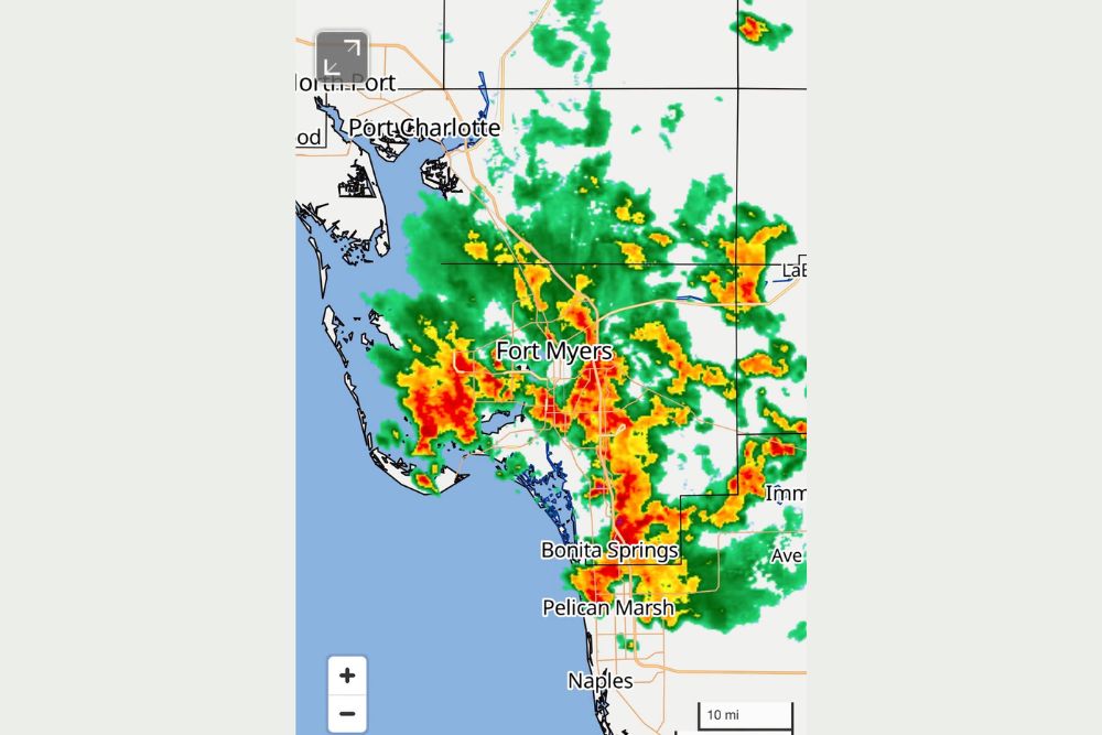
FORT MYERS, FL — Heavy rounds of tropical downpours swept across Lee County and Collier County on Thursday, prompting a flood advisory that remains in effect until 11:30 for communities stretching from Port Charlotte and North Port down through Fort Myers, Bonita Springs, and Naples. Radar imagery captured intense red-core convective cells parked directly over the Fort Myers metro area, signaling rainfall rates capable of quickly overwhelming storm drains and low-lying roadways.
Remnants of Tropical Storm Dolly Fuel the Rain
The moisture fueling this outbreak is not new to the region. It is the lingering tropical moisture plume left behind by what was once Tropical Storm Dolly, a system that spun up over the Atlantic before losing its organized structure and dissipating into a broad, moisture-rich remnant area. While Dolly itself no longer exists as a defined tropical cyclone, the atmospheric footprint it left behind has continued to stream deep, saturated air into the Florida peninsula, feeding one round of storms after another across the southwestern coast.
Why Southwest Florida Is Bearing the Brunt
Southwest Florida sits in a geographically vulnerable position during setups like this one. Onshore flow off the Gulf of Mexico combines with daytime heating and the lingering tropical moisture to produce exactly the kind of training-cell pattern visible on radar Thursday, where storm after storm tracks over the same corridor. That repetition is what turns a routine summer downpour into a flood advisory.
The radar loop shows the heaviest yellow and red returns concentrated in a band running from just west of Fort Myers through the downtown corridor and pushing south toward Bonita Springs. Slow storm motion, common in tropical air masses with weak steering winds, has allowed these cells to dump rainfall over the same neighborhoods for an extended stretch rather than moving through quickly, which is precisely the ingredient that leads meteorologists to issue advisories for urban and small stream flooding.
What the Flood Advisory Means for Residents
A flood advisory, distinct from the more serious flood warning, indicates that nuisance and localized flooding is expected rather than a life-threatening, widespread event. Even so, the National Weather Service cautions that water can pool rapidly on roadways, in underpasses, and in poor-drainage neighborhoods throughout southwestern Lee County. Motorists are urged to avoid driving through standing water, since even a few inches can stall a vehicle or conceal a washed-out road surface.
Low-lying streets in and around Fort Myers, Pelican Marsh, and coastal sections of Naples are considered the most susceptible to ponding given their proximity to canals and the Gulf’s tidal influence. Residents in these areas are advised to monitor local alerts closely as additional rounds of rain remain possible through the remainder of the afternoon and evening hours.
A Pattern Likely to Continue
Forecasters tracking the breakdown of Dolly’s remnant moisture have noted that this plume is expected to keep influencing Florida’s rain chances even after the storm’s dissipation, with widespread rainfall totals possible across the southern half of the state in the days ahead. For a region that has also been contending with pockets of abnormally dry conditions this summer, the rainfall carries a silver lining, replenishing soil moisture and helping ease localized drought concerns, even as it creates short-term headaches on the roads.
Meteorologists note that this kind of setup, where a dissipated tropical system’s leftover moisture continues to organize thunderstorm activity well after the storm itself is gone, is a common late-summer feature across the Gulf Coast. It underscores how tropical systems can influence weather patterns for days or even weeks beyond their official lifespan as a named storm.
Looking Ahead for Southwest Florida
Meteorologists will continue monitoring radar trends through the evening as the current advisory window closes, watching for any redevelopment of heavy cells over the same saturated corridor. Additional flood products could be issued if new convection forms over already-soaked ground in Lee and Collier Counties.
Residents across the Fort Myers, Port Charlotte, Bonita Springs, and Naples areas should keep an eye on updated NWS guidance, avoid unnecessary travel through flood-prone zones, and prepare for the possibility of further advisories as the tropical moisture plume continues to work through the region.
For continuing coverage of severe weather events and critical storm analysis across the United States, visit svhsnow.com.