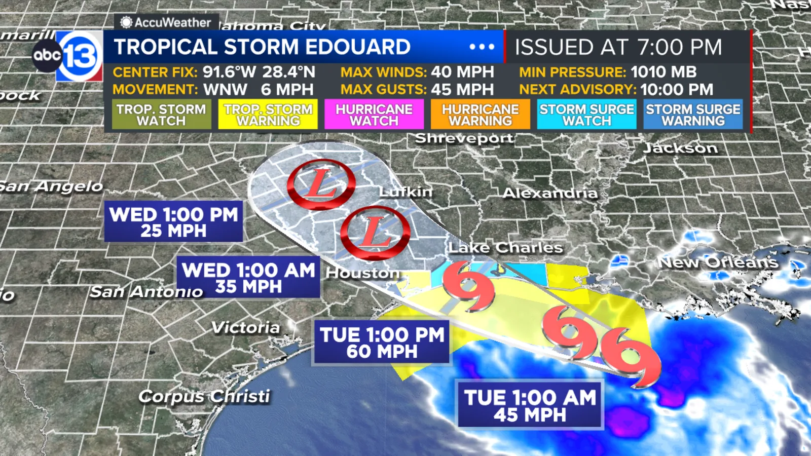
HOUSTON, TX — Tropical Storm Edouard has formed in the Gulf and is expected to bring the first major impacts to Southeast Texas on Tuesday, with the threat continuing into Wednesday. ABC13 has issued a Weather Alert Day for Tuesday and a Weather Watch that runs through Wednesday.
The main concern is heavy tropical rain that could quickly overwhelm streets and low-lying areas. Forecasters also say strong wind gusts and a minor coastal surge are possible, especially near the coast and east of the storm’s landfall point.
Moisture begins increasing along the coast Tuesday morning, but most locations should still see a fairly normal start to the day. The more serious round of rain and storms is expected by afternoon and evening, particularly east of Interstate 45.
Flood Watch Covers Nine Counties
A Flood Watch is in effect from 1 a.m. Tuesday through 7 a.m. Wednesday for Harris, Brazoria, Fort Bend, Galveston, Montgomery, Chambers, Liberty, San Jacinto, and Polk counties. Officials are warning that repeated tropical downpours could produce street flooding, urban flooding, and flash flooding at times.
Rain totals of 3 to 5 inches are expected to be widespread across the watch area, and isolated pockets could receive 6 to 9 inches, with the higher totals most likely east of I-45. That is where the strongest impacts are also expected, including the chance for localized power outages if wind gusts become strong enough.
Drivers heading home late Tuesday could face the worst conditions as the storm’s core moves inland. The timing raises the risk of water-covered roads and sudden changes in visibility during the evening commute.
Landfall Window and Coastal Impacts
Edouard is moving slowly northwest and is expected to keep tropical storm strength as it approaches the Texas coast. Landfall is likely Tuesday afternoon or evening somewhere between Galveston Bay and Sabine Pass, according to ABC13 meteorologists.
A Tropical Storm Warning is in effect for Chambers County and for the coastal waters offshore from Galveston Island to the Bolivar Peninsula, including Galveston Bay. In the warned area, tropical-storm-force gusts could reach 70 mph at times.
Along and east of the landfall location, a storm surge of 1 to 4 feet above normally dry ground is possible. That combination of surge, wind, and heavy rain is what makes the coast especially vulnerable during the highest-impact part of the storm.
What Follows After Tuesday
Rain chances do not end after the main tropical impact day. Lingering circulation is expected to stay over or just north of Houston on Wednesday morning, which could bring wrap-around showers and storms and additional street flooding, especially north of Interstate 10.
Some showers and storms may linger through Thursday as tropical moisture slowly fades. Forecasters do not expect the system to stall and prolong the rain pattern beyond that point, but any extra rainfall could add to flooding already caused on Tuesday and Wednesday.
Temperatures are expected to stay in the low to mid 90s during the rainy stretch, with humid mornings in the mid to upper 70s. After Edouard moves out, hot and calmer weather should return, with highs in the mid to upper 90s and a few sea-breeze showers possible from Saturday through Monday.
When the weather turns dangerous, SVH Snow is watching.