PUEBLO, CO — Scattered showers and a few storms are filling into southern Colorado tonight, with forecasters expecting this activity to slowly drift northward as the overnight hours progress. Some really good downpours have already been reported in the mountains tonight, part of a broader pattern of active weather stretching across the southern half of the state.
Storms Concentrate Across Southern Colorado
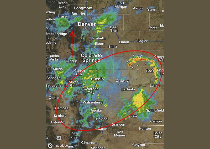
Radar imagery captured at 8:43 PM shows an extensive area of showers and thunderstorms filling into southern Colorado, with the most intense activity concentrated within a highlighted zone stretching from near Pueblo and Cañon City eastward through Ordway, La Junta, and toward Lamar and Springfield near the Kansas border. Several storm cells within this zone display lightning strike indicators, particularly near Cheyenne Wells and Eads, suggesting these cells have developed sufficient intensity to produce active thunderstorm behavior.
The overall coverage extends across a substantial portion of southern Colorado, with additional shower activity visible farther west near Alamosa, Trinidad, and along the mountain corridor stretching from Salida down through Saguache.
Good Downpours Reported in the Mountains
Forecasters specifically highlighted that some really good downpours have been reported in the mountains tonight, an encouraging development for a region that often benefits significantly from mountain precipitation feeding into local water supplies. This kind of beneficial mountain rainfall is a welcome outcome from tonight’s scattered storm activity, particularly heading into the state’s typically drier autumn months.
Radar shows notable activity across the mountainous terrain near Breckenridge, Leadville, and Buena Vista, consistent with the kind of terrain-enhanced precipitation that frequently develops when moisture and instability interact with Colorado’s higher elevations.
Activity Expected to Drift Northward Overnight
Forecasters indicated that tonight’s scattered showers and storms should slowly drift northward as the overnight hours continue, a trend illustrated by the arrow on the radar map pointing from the Guffey area up toward Fairplay and the broader Front Range foothills. This gradual northward movement suggests areas currently seeing lighter or no precipitation farther north could see activity develop as the night progresses.
Communities including Fort Collins, Longmont, and Boulder, currently showing lighter radar returns compared to the more active southern zone, may see this activity spread their way overnight as the broader pattern continues its slow drift northward.
A Highlighted Zone of Continued Storm Activity
The circled area on tonight’s radar map, spanning from north of Pueblo eastward through Ordway and La Junta to Lamar and Springfield, represents the zone forecasters are watching most closely for continued shower and thunderstorm development tonight. This area captures both the currently active lightning-producing cells near the Kansas border and the broader coverage of scattered showers extending across the southeastern plains.
Communities within this highlighted zone should expect continued unsettled weather through the evening and into the overnight hours, consistent with the pattern of scattered, sometimes locally intense activity currently visible across the region.
A Routine Update Ahead of Tomorrow Morning
Forecasters indicated they will provide their regular update at 6:30 AM, suggesting tonight’s overview represents a routine evening check-in on ongoing conditions rather than an escalating or rapidly evolving severe weather situation. This kind of standard nightly update cadence reflects the generally manageable nature of tonight’s scattered storm activity across southern Colorado.
What Residents Should Expect
Residents across southern Colorado, particularly in the corridor from Pueblo through La Junta and toward Lamar, should expect continued scattered showers and thunderstorms tonight, with the potential for locally heavy downpours similar to those already reported in the mountains. As this activity slowly drifts northward overnight, areas closer to the Front Range and Denver metro may see conditions develop later in the night.
For continuing coverage of severe weather events and critical storm analysis across the United States, visit svhsnow.com.