SPRINGFIELD, IL — Multiple rounds of heavy rain and thunderstorms are forecast to move through Illinois next week, with the greatest potential for the heaviest rainfall focusing on Wednesday, according to the latest forecast data. Forecasters say several inches of rain are possible by next weekend, as a significant multi-day rain event takes shape across the state and surrounding region.
Forecast Data Points to a Wet Week Ahead
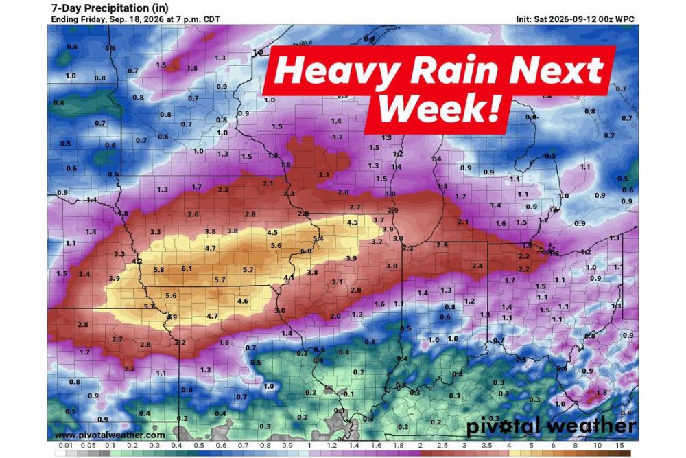
The latest 7-day precipitation outlook, valid through Friday, September 18, shows a broad swath of heavy rainfall potential stretching across Illinois, with the heaviest totals concentrated in a corridor running through the central and western portions of the state. This forecast, initialized on Saturday, September 12, highlights a pattern of repeated rounds of rain and thunderstorms rather than a single, short-duration system passing through the region.
The extended nature of this forecast, spanning a full week, reflects an unusually active pattern setting up across Illinois and neighboring states, with the potential for substantial cumulative rainfall by the time the entire event concludes.
Wednesday Highlighted as the Focus for Heaviest Rain
Forecasters specifically pointed to Wednesday as the day carrying the greatest potential for the heaviest rainfall within this multi-day event. That timing suggests residents across Illinois should pay particularly close attention to forecasts as the middle of next week approaches, since the most significant rainfall totals and any associated flooding concerns are likely to be tied most directly to that specific day.
While rain and thunderstorm chances are expected to persist across multiple days within the forecast window, the emphasis on Wednesday as the focal point suggests forecasters have identified a specific feature, likely an area of low pressure or a stalled boundary, expected to maximize rainfall production on that particular day.
Heaviest Totals Concentrated in Central and Western Illinois
Forecast mapping shows the most extreme rainfall totals, potentially exceeding 5 to 6 inches, concentrated in a band stretching across central and western portions of the state and into neighboring Missouri and Iowa. This corridor of exceptionally heavy rainfall potential represents the area most likely to see significant, and potentially problematic, accumulation by the end of the forecast period.
Areas farther from this concentrated zone, including much of northern and southern Illinois, are still forecast to see substantial rainfall, generally in the 1 to 3 inch range, though at notably lower totals compared to the corridor of heaviest activity running through the central portion of the state.
Several Inches Possible by Next Weekend
Forecasters indicated that several inches of rain are possible by next weekend across the affected region, reflecting the cumulative effect of multiple rounds of rain and thunderstorms adding up over the course of the week-long forecast period. This total is expected to build progressively as each successive round of precipitation moves through, rather than arriving all at once in a single event.
The scale of these potential totals, particularly in the corridor of heaviest forecast rainfall, raises the possibility of localized flooding concerns in low-lying areas and locations with poor drainage, especially if the heaviest bands set up repeatedly over the same communities as the week progresses.
A Broader Regional Pattern Taking Shape
This forecast for Illinois appears to be part of a broader, more widespread wet pattern affecting a significant portion of the Midwest, with the heaviest rainfall corridor extending westward into Missouri and Iowa as well. This regional scope suggests the underlying weather pattern driving next week’s rain is a substantial one, capable of producing significant rainfall across multiple states simultaneously rather than being confined to a single, localized area.
Communities throughout Illinois, from Springfield and Peoria to areas near Chicago and Rockford, should prepare for the possibility of multiple rounds of rain and thunderstorms throughout the week, with the specific timing and intensity likely to become clearer as Wednesday approaches.
What Residents Should Expect
Residents across Illinois should prepare for an active and potentially wet week ahead, with multiple rounds of rain and thunderstorms expected to move through the state, and Wednesday standing out as the day with the greatest potential for the heaviest rainfall. Given the possibility of several inches of rain accumulating by next weekend, residents in flood-prone areas should stay especially alert to forecast updates as the event unfolds.
For continuing coverage of severe weather events and critical storm analysis across the United States, visit svhsnow.com.