CARBONDALE, IL — Southern Illinois is in the midst of a record-breaking heat wave, and forecasters say this is only the beginning, with temperatures in the hardest-hit region already near 100 degrees the past couple of days and expected to stay in the upper 90s into Saturday. Heat index values of 100 to 110 degrees are likely every single day for the next several days, an unusual and dangerous stretch given how deep into mid-September the region has moved.
Deep South Illinois Faces the Most Extreme Heat
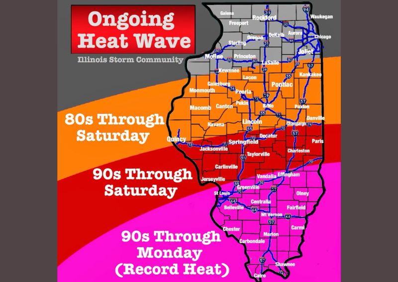
The southernmost portion of Illinois, highlighted in pink on the latest forecast mapping, is experiencing the most severe conditions of this ongoing heat wave. Communities including Carbondale, Marion, Carmi, and Cairo have already seen temperatures near 100 degrees over the past couple of days, with that intensity expected to persist through Saturday before slightly moderating into the low-to-mid 90s for a couple of days heading into early next week.
Forecasters were emphatic that this qualifies as a genuine record heat wave, stressing that given the calendar has moved into mid-September, this level of heat should not be occurring. That combination of record-setting temperatures and unusually late timing is what elevates this event beyond a typical late-summer warm spell.
Central Illinois Also Deals With Dangerous Heat
The red-shaded region across central Illinois, including Springfield, Decatur, Charleston, and Taylorville, is also experiencing hot conditions, though slightly less extreme than the pink zone farther south, with temperatures in the low 90s. This heat is forecast to continue through Saturday, before easing into the 80s by Monday and potentially the 70s sometime after that.
While not quite as severe as the record-level heat gripping southern Illinois, this red zone still represents meaningfully above-average conditions for communities across the central part of the state, extending the footprint of dangerous heat well beyond just the southernmost counties.
Northern and Central-North Illinois See Comparatively Cooler Conditions
The orange region, covering areas including Peoria, Bloomington-Normal, Kankakee, and Danville, will remain cooler than the zones farther south, with highs generally in the 80s for the next several days. Even so, forecasters noted these readings remain well above average for this point in September, meaning even the “cooler” portion of the state is not experiencing anything close to typical conditions.
Farther north still, the gray-shaded area encompassing Chicago, Rockford, and Joliet falls outside the most intense heat zones altogether, though the overall statewide pattern reflects an unusually warm setup extending across a large portion of Illinois this week.
Heat Indices of 100 to 110 Likely Every Day
Perhaps the most concerning detail in this outlook is the forecast for heat index values of 100 to 110 degrees likely every day for the next several days across the hardest-hit southern region. That range represents genuinely dangerous heat conditions, capable of posing serious health risks to anyone spending extended time outdoors without adequate hydration or cooling.
This kind of sustained, multi-day stretch of triple-digit heat index readings is uncommon even during peak summer, making its appearance in mid-September an especially notable and hazardous development for residents across the affected counties.
Relief May Come Next Week, But Forecasters Remain Cautious
Forecasters indicated they think some cooler weather is likely arriving next week, but were careful to temper that outlook given recent history: they had also expected relief to arrive this week, and instead the region ended up in a historic heat wave. That track record has made forecasters deliberately cautious about promising a specific timeline for when temperatures will finally return to normal.
This measured approach reflects an appropriate level of humility given how this particular heat wave has already defied earlier expectations for cooling, reinforcing that residents should continue monitoring updated forecasts rather than assuming relief is guaranteed by any specific date.
This Isn’t Normal, But Cooler Air Is Coming Eventually
Forecasters closed with a direct message to residents: stay cool, this isn’t normal, and temperatures are bound to cool down at some point as the region moves closer to the Fall Equinox. That framing acknowledges both the genuine abnormality of the current heat wave and the underlying confidence that the broader seasonal transition toward autumn will eventually assert itself, even if the exact timing remains uncertain for now.
What Residents Should Expect
Residents across southern Illinois, particularly in the pink zone stretching from Springfield south to Cairo, should prepare for continued near-record heat with dangerous heat index values through at least Saturday, with only gradual and uncertain improvement expected into next week. Given the historic nature of this heat wave and the forecasters’ own caution about promising relief, residents should continue taking heat safety precautions seriously throughout the coming days.
For continuing coverage of severe weather events and critical storm analysis across the United States, visit svhsnow.com.