FORT WAYNE, IN — A flash flood risk is increasing tonight into tomorrow morning across northern Indiana and portions of the surrounding region, as repeated rounds of thunderstorms could produce very heavy rainfall along a stalled boundary. Some areas may pick up 1 to 3 inches or more by tomorrow afternoon, especially where storms repeatedly track over the same locations, with rainfall rates potentially exceeding 2.00 inches per hour.
A Stalled Boundary Sets the Stage for Repeated Storms
Thunderstorms are expected to develop overnight tonight into tomorrow morning along a stalled stationary boundary draped across northern Indiana, stretching roughly from near South Bend through Fort Wayne. Storms are expected to move along this feature, a setup that often produces the kind of repeated, training thunderstorm activity capable of rapidly compounding rainfall totals in the same locations.
This stationary boundary is the key driver behind tonight’s elevated flood risk, since a boundary that isn’t moving allows storm cell after storm cell to track over similar areas rather than spreading rainfall more evenly across a broader region.
Highest Risk Concentrated Along the Northern Corridor
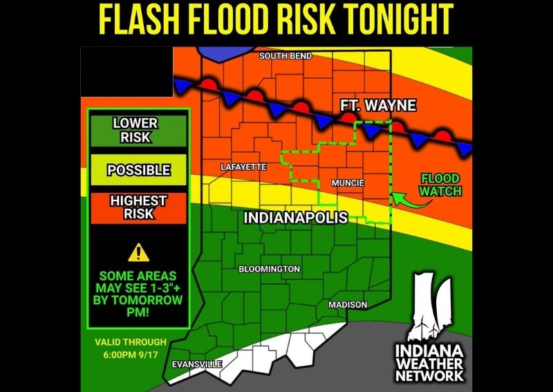
Forecast risk mapping shows the highest risk category, shaded in orange, stretching in a band from near South Bend through Fort Wayne and toward Muncie, directly along the path of the stalled boundary. This corridor represents the area where forecasters have the greatest confidence that repeated thunderstorm activity will produce the most significant rainfall totals overnight and into tomorrow.
A Flood Watch, outlined in the green dashed boundary on the map, covers a substantial area including Fort Wayne and extending south toward Muncie, formally recognizing the elevated potential for flooding across that zone through the specified timeframe.
Some Areas Could See 1 to 3 Inches or More
Forecasters specifically warned that some areas within the highest risk zone may pick up 1 to 3 inches of rain or more by tomorrow afternoon, particularly in locations where storms repeatedly track over the same spot. That kind of localized, repeated storm activity, known as training, can produce dramatically higher rainfall totals in specific areas compared to the surrounding region, even when the broader system covers a wide geographic footprint.
Adding to the concern, forecasters noted that rainfall rates during the heaviest storms may exceed 2.00 inches per hour, an intensity capable of quickly overwhelming drainage systems and creating flash flooding conditions even before the storm’s total accumulation reaches its highest point.
Lower Risk and Possible Categories Extend Farther South
South of the highest risk corridor, a yellow “possible” zone extends through areas including Lafayette and Indianapolis, indicating a real but lower likelihood of significant flooding impacts compared to the northern corridor. Farther south still, a green “lower risk” zone covers Bloomington and Madison, reflecting a still-lower probability that this event produces flooding concerns in that part of the state.
This tiered risk structure, spanning from lower risk through possible to highest risk, helps residents across different parts of Indiana understand roughly how likely they are to see the kind of flooding impacts associated with tonight’s storm system based on their specific location relative to the stalled boundary.
Guidance Differs on Exact Locations and Amounts
Forecasters were transparent in noting that while model guidance does differ on the exact locations and heaviest rainfall amounts expected with this system, the overall potential for moderate to heavy rainfall remains clear for tonight into tomorrow. This acknowledgment of forecast uncertainty is an important detail, since it means the specific placement of the highest rainfall totals could still shift somewhat as the overnight event unfolds.
Despite that uncertainty in precise details, the broader signal supporting a genuine flash flooding concern across northern Indiana has remained consistent enough for forecasters to issue this elevated risk outlook and the accompanying Flood Watch.
Flood Watch Remains in Effect Through Wednesday Evening
The current Flood Watch and elevated risk outlook remains valid through 6:00 PM on September 17, giving residents across the affected area a defined window during which the flash flooding threat is expected to remain active. This extended timeframe, covering both the overnight hours and much of the following day, reflects how long the stalled boundary and its associated repeated storm activity are expected to affect the region.
Never Drive Through Flooded Roads
Officials reiterated the critical safety message associated with any flash flood risk: never drive through flooded roads, and always remember to Turn Around, Don’t Drown. This warning remains especially relevant given the potential for rainfall rates exceeding 2 inches per hour, conditions capable of transforming a normally passable roadway into a dangerous flooded crossing within a very short period of time.
What Residents Should Expect
Residents across northern Indiana, particularly along the corridor from South Bend through Fort Wayne and toward Muncie, should prepare for repeated rounds of thunderstorms overnight and into tomorrow, with the potential for 1 to 3 inches or more of rainfall in the hardest-hit locations. Given the risk of flash flooding through 6:00 PM tomorrow, residents should avoid unnecessary travel through low-lying or flood-prone areas and never attempt to drive through standing water on roadways.
For continuing coverage of severe weather events and critical storm analysis across the United States, visit svhsnow.com.