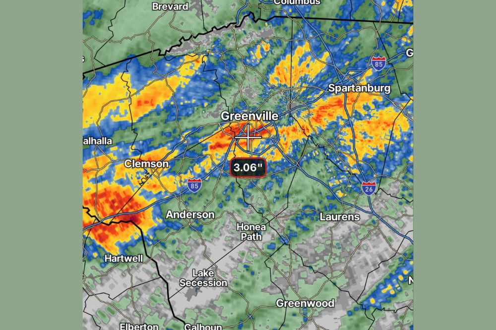
GREENVILLE, SC — Heavy rain dumped more than 3 inches across a large swath of the South Carolina Upstate today, with radar-confirmed rainfall totals reaching as high as 3.06 inches near Greenville and widespread heavy activity affecting communities throughout the region, including portions of Spartanburg, Anderson, and Clemson. The rainfall represents a significant precipitation event for the Upstate, with numerous locations across the region likely reporting similarly substantial totals from today’s storms.
Rainfall Totals Confirm a Widespread Heavy Rain Event
Radar-estimated rainfall data pinpointed a total of 3.06 inches directly over Greenville, illustrating the intensity of today’s rainfall in the heart of the Upstate’s largest city. This substantial single-location total reflects the kind of sustained, heavy rainfall capable of producing localized flooding concerns and significant runoff in urban and suburban areas throughout the region.
The radar imagery shows an extensive area of heavy rainfall, indicated by red and orange coloring, stretching across a broad corridor from near Clemson and Anderson in the west through Greenville and continuing east toward Spartanburg, illustrating just how widespread today’s heavy rainfall became across the Upstate region.
Multiple Bands of Intense Rainfall Track Across the Region
Radar data shows several distinct bands of the heaviest rainfall moving across the Upstate, with one particularly intense area stretching from west of Anderson through Clemson and toward Hartwell, and another significant band extending from Greenville eastward through Spartanburg and toward the Interstate 85 corridor near the North Carolina border. This multi-band structure suggests today’s rain event involved more than a single storm system, with repeated waves of heavy rainfall affecting different portions of the region throughout the day.
The presence of these multiple heavy rainfall bands across such a wide geographic area indicates a broader atmospheric setup favorable for widespread, intense rainfall production, rather than an isolated storm cell affecting just one specific location within the Upstate.
Communities Across the Upstate See Significant Totals
Beyond the confirmed 3.06 inch total at Greenville, radar imagery suggests similarly substantial rainfall likely occurred across numerous other Upstate communities positioned within the heaviest rainfall bands. Areas including Clemson, Anderson, and communities along the I-85 corridor toward Spartanburg all appear to have experienced comparable or potentially even higher rainfall totals based on the radar-indicated intensity in those specific zones.
Given the widespread nature of today’s rainfall, it’s likely that individual rain gauge reports and personal observations from residents across the region, similar to the reported 3-inch total at one Greenville-area home, will continue to paint a fuller picture of just how substantial this rain event became across different pockets of the Upstate.
A Notable Rainfall Event for the Region
Rainfall totals exceeding 3 inches in a single day represent a significant precipitation event for the South Carolina Upstate, an amount capable of causing localized flooding, particularly in low-lying areas, urban drainage systems, and locations near creeks and streams that can rise quickly following intense rainfall. The scale of today’s event, covering a large swath of the region rather than a small, isolated area, amplifies the potential for cumulative impacts across multiple communities.
Given the widespread coverage of heavy rainfall shown on radar, residents throughout the Upstate, from Brevard near the North Carolina line down through Anderson and toward Laurens, may have experienced meaningfully different rainfall totals depending on their exact location relative to the heaviest bands that moved through the region today.
Potential for Localized Flooding Concerns
With confirmed totals already exceeding 3 inches in portions of Greenville, and similar or potentially higher totals likely across other parts of the Upstate, the potential exists for localized flooding in areas with poor drainage or those situated near smaller waterways prone to rapid rises following heavy rainfall. Residents in flood-prone areas of the Upstate should remain cautious of standing water on roadways and any signs of rising water near local creeks and streams.
The widespread nature of today’s rainfall, rather than a concentrated, isolated downpour, increases the likelihood that multiple communities across the region could experience at least some degree of localized flooding or drainage issues following such a substantial rain event.
What Residents Should Expect
Residents across the South Carolina Upstate, including Greenville, Spartanburg, Anderson, and Clemson, should remain aware of the potential for lingering effects from today’s heavy rainfall, including possible localized flooding and elevated water levels in local waterways in the hours following such a substantial precipitation event. Given the scale of rainfall recorded across the region, continued monitoring of local conditions is advisable as saturated ground and full drainage systems work to handle the aftermath of today’s storms.
For continuing coverage of severe weather events and critical storm analysis across the United States, visit svhsnow.com.